This Adventurous Age

Adventures travelling and working around Australia.


Leave a comment

2000 Travels March 14

TUESDAY 14 MARCH     STANLEY

I had noticed that we were sleeping in later – until 9 or 10am. The mornings seem much darker.

This day was not windy, but there was some light rain and it was a grey day, but it cleared up a bit later in the day.

We went for a drive – to Smithton, first. The hinterland country behind the coast in these parts is rich farming country – some cropping and dairy cows. There are plenty of timbered areas left though – beside the roads, along creeks, and just at random.

It is surprisingly pleasant to be back in farmed country. Guess we’d just had our fill of the west coast wilderness country, for a while.

At Smithton, called in at the big Gunns timber mill, but they were not really interested in visitors, or showing timber or discussing small scale purchases.

From Smithon, took the Montague road, which stays closer to the coast than the highway. Turned off that to go to the coast, along the gravel road to the old Montague port, and the council’s seafront camping area.

From here, we looked out across a narrow, tidal, stretch of water, to the large Robbins Island, not far away. This island is privately owned, and farmed.

We sat there, in Truck, to eat our packed lunch – it was not warm enough to venture outside – looking out across the channel.

Out on the tidal sand flats, there were some black lumps. John viewed these through his binoculars and pronounced them to be rocks. I little later, I could swear that some of the rocks moved! Then they grew legs and necks and turned into swans. John swore they were originally rocks!

We drove back to Smithon and went to Brittons timber mill there. They were quite welcoming. We were shown their veneering mill and the process for making same which was really interesting. Essentially, the timber is cut into long, thin, sheets – it was amazing how thin the veneer slices were.

03-13-2000 veneer mill smithton.jpg

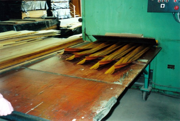
The veneer mill at Brittons

We had previously been told, at a couple of the sawmills we’d visited, that veneer mills get the best logs. There were certainly some good looking veneer sheets being made.

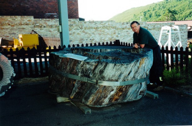
John was really interested in the remains from the veneering process – the end offcut lumps, with their potential for turning on a lathe. Also interesting were the thinner boards they produced – useful for making wooden boxes.

03-14-2000 nice boards left after veneering.jpg

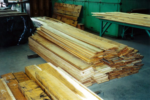
Good looking boards left after the veneering process

We were then shown the Sales Room, which contained some superb products from wood workers, some using veneers really well. There was a display of pieces of all the different timber types.

John bought several turning blanks – lovely patterned pieces – that cost $2 a kilo, regardless of timber type. That might have sounded cheap, but wood is heavy stuff! We also got some veneer samples, and took a number of photos. That was another really good timber place to find.

Back to camp, then, having driven 90kms.  Photographed today’s booty, then John packed it away in Truck.

03-13-2000 brittens purchases.jpg

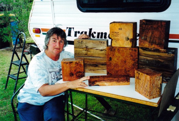
Turning blocks bought from Brittons

Tea was vegie and barley soup, salad and tinned fish.


Leave a comment

2000 Travels March 13

MONDAY 13 MARCH     STANLEY

The day was wet and windy. The winds were very strong. The van was rocking from the wind.

We stayed in, apart from a quick walk to the shops for the paper, in a break in the rain.

03-14-2000 stanley wet day.jpg

Wet day in Stanley – travelling is not always comfortable!

The wind died a little, later in the day.

I made a batch of vegie and barley soup.

Tea was bush flavoured seasoned chops – bought that way, potato, broccoli.

There have not been too many times in Tassie when the weather has kept us indoors for two days straight! Or when Truck has not been driven for three days in a row.


Leave a comment

2000 Travels March 12

SUNDAY 12 MARCH     STANLEY

I walked up to the shops for the Sunday paper.

Met S again! With the black lab. Such is the way of a small town. I told her about the Desert Parks Pass operating in SA and the associated maps that one gets as part of the information pack.

It was a very windy day – blowing a gale, it seemed. Then it rained. So it was not a day for doing much except reading the papers. I did some work on share materials.

John put some extra guy ropes on the awning.

S and husband M called in during the afternoon. He inspected the van. I talked with her about the Flinders Ranges.

In chatting, it turned out that their travelling companions were my cousin, K and his wife, A. K was the son of dad’s older brother, but I had never met him. S gave me their phone number and said she would mention meeting us, to them. They live in Wynyard and have a van here in the park, so they are often here on weekends. Tasmania is a very small world!

M pointed out that Stanley is “7kms out to sea” so to speak, and thus it is often windy. Guess that is one way to look at it.

Tea was cold chicken, potato and broccoli.

During the night, the wind was strong enough to rock the van!


Leave a comment

2000 Travels March 11

SATURDAY 11 MARCH     STANLEY

I was up before John and walked up to the shops for the papers. On my way back, I was stopped by a lady who was walking a black labrador dog. She had seen the Cooktown T shirt I was wearing and wanted to talk travel. I admired her dog – she said it was a neighbour’s, and she just did them a favour, walking it.

S is from Burnie and has a holiday house here. She and her husband are teachers and are planning a trip to Innamincka and the Flinders Ranges in the mid-year holidays. She asked if she could come round to the van, later, with some maps, to have a consult.

Read the papers for the rest of the morning. We had decided to have a fairly quiet day, after yesterday’s travel.

After lunch, we walked to the base of The Nut, where the walking track goes up it. There was also a chairlift for those who wanted. It was a stiff climb up, then we walked around the large flat area that is its top. It was much better up there than I had anticipated. There was a variety of outlooks – along the coast, over the town, and almost straight down to the little port section, below. We spent about an hour up there, watching the activity around the port. There was also an outlook over the historic Highfield property, that occupies the rest of the Circular Head promontory of land behind The Nut.

I didn’t take the camera, figuring we’d be going up again, another day, and rather regretted it when I saw how much of interest there was.

While I was roasting the chicken and vegies for tea, S called in – she’d been by earlier, with maps, but we were out. She said she’d bring her husband round at some stage over the weekend.

Got chatting with four people from vans behind us. It turned out they were friends of the couple that we’d gotten to know in the caravan park at Berriedale. They have moved back into their east coast house, but apparently he was still fretting to travel more. I could relate to that!

03-12-2000 dusk stanley.jpg

Dusk at Stanley – tide out

Phoned K and left a message for him to send the mail, mid-week, to Burnie. We should be heading that way when we leave here, so can collect it then. Have also been in contact with the bank, and our new Mastercards are being sent to the bank there.


2 Comments

2000 Travels March 10

FRIDAY 10 MARCH   ZEEHAN TO STANLEY   235kms

There was light drizzling rain when we got up in the morning.

Knowing we had a comparatively long drive ahead of us, we were away about 9am. Had to get fuel in town before we left – 93cpl.

It was slow and careful driving to Rosebery and Tullah and on up to Waratah Junction. We could smell the brakes a couple of times, especially on the big hill out of Rosebery. The country was a mix of forests and the open swampy heathlands common on the west coast.

At Waratah Junction, we turned off the Murchison Highway onto the Burnie road. This road was fine – it used to be the private road for the APPM trucks. Going that way allowed us to avoid the Hellyer Gorge.

Came to the coast at Burnie. Saw a Woolworths supermarket so we stopped to have a shop – first decent stock up I’d done for a while.

Turned west on the Bass Highway, along the coast. This was winding and fairly slow – but a pleasant change in scenery from the forests of the past few weeks.

Turned off the highway and drove down into Boat Harbour – a hamlet of holiday houses, mostly – and sat in Truck to eat our lunch, with a pleasant outlook over the bay and beach. It had turned into a nice day at the coast.

Back onto the highway and we arrived at our destination, Stanley, mid afternoon. We’d chosen to come here as a base to explore some of the north west, that seemed to offer history, scenery and be fairly central for what we planned to do.

Stanley is interesting, geographically, being situated at the base of The Nut – a volcanic plug – which is a really impressive, square, high, hill, rising out of the sea, it seems. The road in follows a narrow neck of land that connects The Nut to the main coast, like a natural causeway, for several kms.

03-21-2000 stanley nut.jpg

The Nut and the township of Stanley beneath it

We booked into the very pleasant Stanley Caravan Park. $13 a night, with the seventh free, which we thought was a very good price, given the standard. It is one of the handful of better caravan parks we have come across in our Tasmanian travels.

03-11-2000 camp stanley.jpg

Our site at Stanley, with the late afternoon sun on The Nut

Set up camp then walked up to the shops for a look around. Up was the operative word, as the township is on the lower flanks of The Nut. The township streets create a kind of terraced effect, with walkways between levels. It is a very pleasant seeming town.

I ordered the papers kept for us at the newsagency. I could see the morning walk up to get the papers would be a lovely way to start the day.

Tea was bought fish and chips.

03-10-2000 to stanley


Leave a comment

2000 Travels March 9

THURSDAY 9 MARCH     ZEEHAN

Stayed around camp in the morning.

I did some work on shares, deciding to sell off some non-performing parcels and buy some that might do better. Worked all of that out, then rang the stockbroker with instructions.

After lunch, we walked around town. Spent a couple of hours at the Museum, which was very good – not as cluttered as the one in Queenstown, and with more discipline and structure.

03-08-2000 huon pine log zeehan.jpg

The trunk of an ancient Huon Pine tree

Zeehan has some really lovely old buildings, chief amongst them the Gaiety Theatre. At one time this was the largest performance theatre in Australia and is a measure of the substance this town had in the boom days.

03-08-2000 old gaiety theatre zeehan

Gaiety Theatre Zeehan – an interesting little adjacent building

We bought some leatherwood honey – Tasmania’s speciality. Then needed crumpets to go with it!

Back at camp, took down the awning.

Tea was soup, salad, crumpets and honey.

I was rather sorry not to have tackled the Montezuma Falls walk, while we were here, but I was not game to take John anywhere near another 4WD track!!


Leave a comment

2000 Travels March 8

WEDNESDAY 8 MARCH     ZEEHAN

Woke to a really cold morning. I got up at 7.15am, but John slept on. Though cold, it was clearly going to be a nice day.

We were curious about the little settlements on the wild west coast itself, so decided to go see those this morning.

Drove to the coast, first, to Trial Harbour, through fairly bleak and windswept moor country. Trial Harbour did not impress as a place I would want to return to – just a collection of about a dozen shacks.

Granville Harbour, to the north, was the next destination.

However, John decided that he really wanted to tackle the 4WD Climes Track to Granville Harbour, which all the literature rated as really difficult. It is only about 25kms, but was supposed to take about three hours to do.

The track became unpleasant, quite soon, with potholes, erosion gullies, rocky sections – and we were still on the relatively easy first section! Some of the angles needed were just about tipping Truck on its side.

I felt really strongly that continuing on it was risking the Truck, beyond reason, and that we were likely to get into a situation where we’d need help to get out – but with no one else around. We disagreed over this. John was determined to continue. I got out and said I’d walk back towards Zeehan and he could pick me up on the way back – because I was sure he would have to turn back. If not, well, I was not going to be an audience to this foolhardiness!

John did turn back. He actually did not go much further beyond where I’d bailed out, before wisdom prevailed.

We took the normal road to Granville Harbour, which was another forgettable collection of fishing shacks. At least, the curiosity was satisfied.

I’d planned for today to be a circuit drive, to continue on to the Pieman River at Corinna and maybe do the river cruise if it was available. Then, the plan was to return via the Reece Dam and Rosebury. It would have been a long-ish circuit, but through interesting wilderness. However, after the couple of hours wasted on the abortive 4WD adventure, it was too late to set out on that circuit – and the mood was not good, anyway!

So, we returned to camp for what was left of the day. We drove 128kms.

03-07-2000 Zeehan camp.jpg

Caravan park at Zeehan – nice and bushy

Tea was soup, tuna and caper pasta.


Leave a comment

2000 Travels March 7

TUESDAY 7 MARCH     QUEENSTOWN TO ZEEHAN   38kms

We slept in – the mornings are so dim, here.

Whilst packing up, I could hear the conversation between our Golf caravan neighbour, who was quite nice, and the man behind him, who arrived a couple of days ago and backed a huge van right up against the Golf. There was not room to walk between the two! Even then, the van was too long for the site and his drawbar sticks out onto the road. Touring in something that big is so limiting. I bet he had some tense times on some of the local, narrow roads!

Anyway, he sounded an absolute bore, so I was pleased he had not come near us. He thought Queenstown and the west coast was “boring” – he’d done absolutely all there was to do, in a couple of days! “Once you’ve seen one mountain, you’ve seen them all”. He felt offended because he thought Queenstown houses were shabby and more effort should have been made to pretty up the place for tourists. (We thought many residents had done a surprisingly good job with their homes, in adverse conditions).

He was one of the “I know it all – I’ve got the best” types that one sometimes encounters. After the Golfers escaped, having listened to him politely, for far too long, he tackled John, who decided to prove he hadn’t seen it all…..he’d never even heard of the Mt McCall drive, or Pillinger, etc. However, he certainly had the heavier van – 2.5tonnes unloaded. Crazy! We wondered what he had in all that space – and how much more it weighed. He also had a big roof rack on his vehicle, fully laden, plus cycles on the back of the vehicle. One wonders why some people bother leaving home.

We had some difficulty hitching up the van, this time. John wanted it swung a bit sideways, beforehand, to make his approach easier, but doing that put a wheel partly off the wood levelling block, so John chocked the jockey wheel. Then it was almost impossible for me to move the van sideways at all, for lining up, so John had to back Truck exactly in line – no margin for error. It took him three attempts to get Truck straight in line with the hitch block. Not one of our better exits!

We did a careful drive to Zeehan on the hilly, winding Zeehan Highway. At least we knew what most of it was like, having travelled it the other day on the way back from Rosebery. At least, it wasn’t far.

The town of Zeehan was on a flat, buttongrass plains approach, not in a valley, as I’d envisaged. But there are some very big hills around it. On first impressions, it seemed more pleasant than Rosebery had, the other day.

Booked into the Treasure Island Caravan Park – $14 a night. The park was pleasantly “bushy”, after the gravel of Queenstown. The amenities were basic, but ok.

We set up, and had lunch.

Zeehan began as a mining centre, in the last part of the 1800’s. Lead and zinc were extracted, then later tin mining became significant. At the height of the silver boom, around 1900, Zeehan’s size was on a par with Hobart and Launceston, but the mining began declining from the early 1900’s, and the town declined too. Now it is just a small isolated town, with some once-lavish old buildings to hint at its past.

Drove to the old smelter site and explored around a very impressive set of ruins. It must have been huge in its silver mining heyday.

03-07-2000 at old smelter ruins Zeehan.jpg

Two photos at the old smelter ruins

03-08-2000 smelter ruins zeehan.jpg

Then we found our way up King Hill – the views were mostly obscured by scrub, but there were massive ranges in the distance. We wandered about the mine remains there – a big poppet head, relay poles for a  haulage way up the hill, part of a turntable.

03-09-2000 mining relics Zeehan.jpg

Mining relics Zeehan

Next was a “little adventure” that John wanted to do. We drove the Spray Track, to the Spray tunnel. This 100 metre long burrow through a hill was originally built in 1901, to bring ore by light rail from the Spray Silver Mine, at its far end, to Zeehan. The tunnel is an unusual keyhole shape – this allowed for the shape of boilers being taken to the mine.

The tunnel is 3 metres high and 2.2 metres wide!

John was determined to do the one-way drive through the tunnel. Once started, drivers are committed to keep going! He tucked the side mirrors in against the Truck body!

03-09-2000 spray tunnel.jpg

Looking into the Spray Tunnel

At the entrance, we could see the other end, so it was not as claustrophobic as I’d feared – but there was not much clearance either side. John did it well. Would have been interesting if we’d broken down and needed to get out of the vehicle!

03-09-2000 spray tunnel truck

Not much clearance room

Looked at the mine remains at the other end, then completed the loop drive back through the bush and to town. It was a very pleasant little excursion.

The caravan park had filled up a bit by the time we got back – there were about six other vans.

I went off for an early shower, thinking to get in before the rush, but still had to wait. Others had the same idea!

Tea was pork and honey sausages I’d bought in Queenstown – very ordinary – and leftover macaroni cheese. I also made borscht soup to use up the beetroot I’ve been carrying around for weeks.

S phoned in the evening, while we were watching TV. While John was talking to her, there were a couple of rifle shots, not too far away. Then, a little while later, there were three shots from much closer – far TOO close! We were both afraid to go out of the van. John phoned the police, as apparently did some others. They came about 20 minutes later and sussed it out. Apparently a local was shooting wallabies. Rather thoughtless of him to come so close. Maybe he doesn’t like tourists?

It was a really cold night.


Leave a comment

2000 Travels March 6

MONDAY 6 MARCH     QUEENSTOWN

Early on, the day looked like there would be high cloud, maybe even some sun.

It was a public holiday in Tasmania – the 8 Hour day; perhaps a bit like our Labour Day.

After breakfast, and completing some odds and ends, we drove out along the unsealed track that follows the old ABT rail alignment. There is a 4WD track that follows this for some of the old route. At Halls Creek, behind the Bradshaw sawmills, there was a sign saying the bridges were unsafe for driving on, any further. To this point, the track had been rather rough, with a number of big, wide, puddles and a ford or weir to cross that was not too deep, but running. Guessed there would have been a bridge there in the rail times.

03-05-2000 old rail alignment near Queenstown.jpg

Road along the old railway alignment out of Queenstown

We ate our packed lunch by the Queen River, at that point, then left Truck parked and started walking.

03-05-2000 Queen River near Queenstown.jpg

Queen River

A few hundred metres from the start, we passed a parked ute, and then a broken bridge. We were able to cross this on a couple of laid planks, but vehicles had made a little side track that forded the creek, below.

03-05-2000 J on old ABT bridge

Narrow track and planks across a rickety bridge

Then we encountered a man picking blackberries. He said his dog had wandered off. Further along, we were passed by a man and a couple of kids on a 4 wheeler buggy.

The track narrowed to normal railway width. We could hear the sound of the rushing waters of Halls Creek to our right, but the valley by then was too deep and forested to see it.

We crossed several bridges that had planks laid over them – obviously for the use by 4WD vehicles. We would never have attempted to take Truck over some of them, though! In one place, a landslip had been used to fill in a gully where a bridge had been, but it looked to be slipping away again.

03-05-2000 old abt bridge

Broken bridge

We plodded steadily up the rising track. This was the 1:16 gradient that had used the ABT cog system – though the rails had long gone, of course.

Eventually we reached the Rinadeena site, that was the highest point on the old railway. There were a few traces of buildings here, if one looked closely, but the area was largely overgrown. It is less than forty years since all was abandoned, but the vegetation grows quickly it seemed.

03-05-2000 was rinadeena yards.jpg

This was open space and rail yards, some 38 years ago – Rinadeena station site

A work site for the railway restoration had been cleared – with a bulldozer there – and an access track coming in from the Strahan road. That was never there before!

There was  a little brown mouse-like creature coming out from the bushes to feed on the ground, and then going back in again. There had been quite a lot of bird life along the track – thrushes and the like.

We walked back to Truck. The blackberry man was gone, but his dog was there. Was nothing we could do about it, except to hope it knew its way home! Or that he would come back, looking.

I thought that, overall, we’d walked about 7 kms.

Drove the Anthony Road again, now that the cloud had lifted. This time, could see big vistas across lakes, to huge mountains. It was obviously a previously glaciated area and was quite awe inspiring, though not as spectacular as John had expected. At the junction with the Murchison Highway, turned around and went back to Queenstown on the same road.

Back in Queenstown, John parked outside a shop, while I went in to get milk. A lady driving a red people mover pulled in, to the No Standing area right in front of him, and in doing so drove too close and grazed the corner of our bull bar – which is solid steel. He was astounded. She actually denied hitting Truck and raced off to the shops. Unbelievable. No damage to us, but John reckoned that, in better light, she’d see the evidence down the side of her van. Her problem!

Drove 130kms today.

We packed up the awning and outside furniture. The lone traveller came over for a chat.

Tea was macaroni cheese.

The stay in Queenstown has been very pleasurable, because we have been able to access so much wonderful, wild, country.

03-05-2000 around qtown.JPG

Assorted explorations from our Queenstown base


Leave a comment

2000 Travels March 5

 SUNDAY 5 MARCH     QUEENSTOWN

It was a misty morning, with some drizzle and not a great deal of visibility. But the forecast was for showers, clearing, so we decided on a drive.

We took the Mt Anthony road – a fairly new one that, presumably was built because of hydro developments. It goes from Queenstown to the Murchison Highway, north of Rosebery. It is much straighter, and shorter, than the highway route and locals use it to avoid the hilly, winding route through Rosebery.

I had the impression that it was really scenic, but we couldn’t see much at all, because of the misty rain. I knew from the map that there were some really high mountains in the area. There was a 10% gradient drop at the northern end, for a couple of kms!

At the highway, we turned left and went to Rosebery. It was still misty. We walked around the streets of the town, looking at the older buildings, and some mining relics. The Pasminco mine there is still operating. Since the shop was open as we passed, I bought a lotto ticket for next week’s jackpot – $3million.

Headed back south on the Murchison Highway and stopped by the Henty River bridge, to eat our lunch – sitting in Truck in steadily pouring rain. It would have been a pretty spot to explore a bit, in dry weather.

Got back to camp about 1.30pm, having driven 133kms.

John was really tired and had a four hour “nap”. I read the weekend papers.

It continued to rain for most of the afternoon. I guessed we were seeing the west coast as it mostly is. Although, even this country has seemed drier than normal – we could see that the hydro dams are well down, and the walking tracks were certainly drier than indicated in track notes.

Talked for a while with a Victorian neighbour – a man travelling alone in a Roadstar van. He seemed lonely and wanting to talk about travels.

The caravan park manager sent another guest over, who had been asking about the Mt McCall track and the Pillinger walk, so we talked with him for a while. I think we convinced him that both were quite do-able with his vehicle. I do think that people who run caravan parks should be more pro-active in producing proper information about what is to be done around their area. It would certainly encourage longer stays.

Tea was steak, mushrooms and green beans.

We decided to stay an extra day to finish off some undone things.

The rain eased off through the night.