This Adventurous Age

Adventures travelling and working around Australia.


Leave a comment

1999 Travels May 19

WEDNESDAY 19 MAY   WILPENA TO COPLEY   185kms

We got up at 8am, which was probably a little late for a moving day.

John did a clean up of the back of Truck, because there was so much dust in there. While he was doing that, I walked down to the office and bought a Desert Parks Pass – cost $60. It is an annual pass to the designated desert areas, and we can renew it next year at a reduced rate, if we wish. We received a sticker to put on the vehicle and a folder of information on the areas covered. It was all quite comprehensive.

John drove Truck to the shop to refuel – 81cpl.

We had not done any preliminary packing up yesterday, so it was about 10.30 when we got away. That was alright because we do not have far to go.

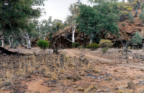
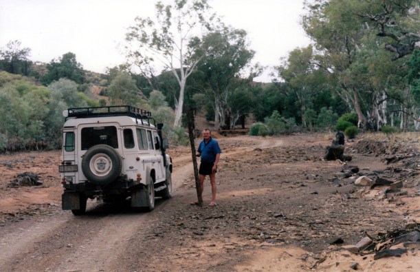
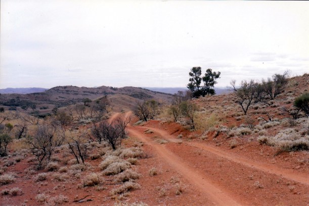
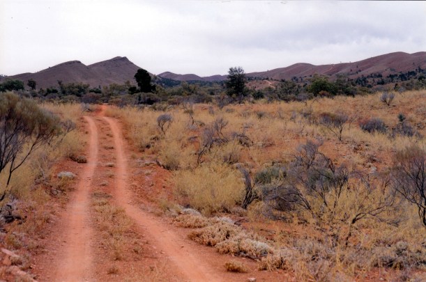
Went south from Wilpena for about 30kms and then took the Moralana Scenic Drive route, that cuts through to the Leigh Creek road. Truck managed it well with the van on the back, and the van towed well on the unsealed surface.

05-19-1999 02 elder range.jpg

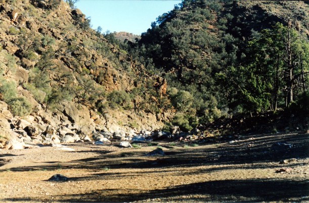
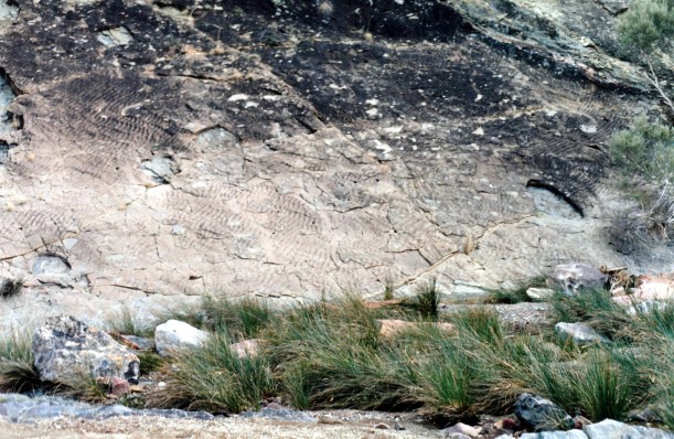
On the Moralana Scenic Drive track

It really is a beautiful way to go, through a valley between the Elder and Heysen Ranges, and then through the little gorge cut by the Moralana Creek, to the sealed road north.

05-19-1999 01 Elder Range from Moralana track

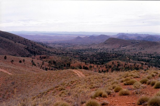
The Elder Range from the Moralana Scenic Drive

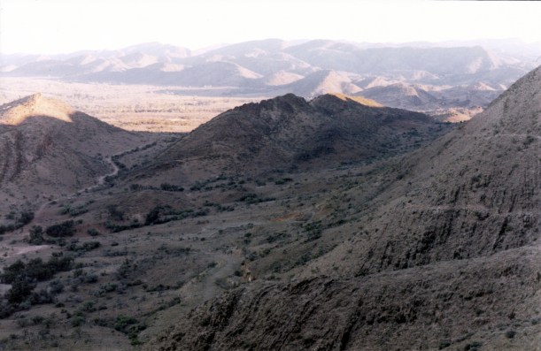
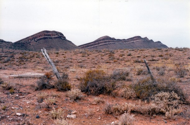
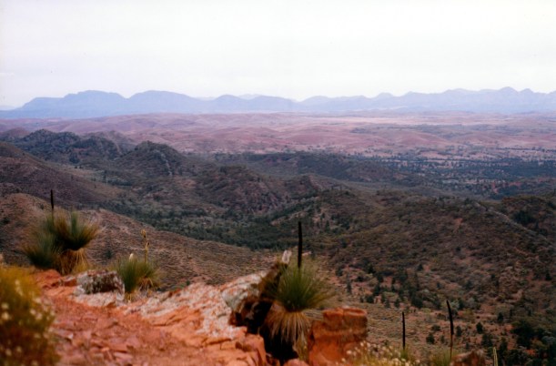
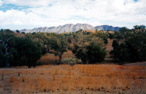
For a while we had the interest of the Ranges to the east of us, but these peter out after Parachilna. After that, it was much flatter,  but there were places where areas of lower hills were visible, like around Beltana and especially coming into Leigh Creek.

05-18-1999 01 flinders from near parachilna.jpg

The Flinders Ranges from the western side, near Parachilna

I am rather amused that, along this road, the railway crosses the watercourses – which are dry now – on bridges, whereas the road is down at stream level rather than on bridges. When they do get the occasional heavy rains, there is nothing to stop the water flowing straight across the road, so I guess this road would soon get closed in such an event. Guess heavy rain must be rare in these parts.

It is noticeably hotter today – I am in shorts and T shirt. Have not needed those for a while.

We stopped at the Beltana Roadhouse and ate our lunch in the parking area there. Bought a beer and icy poles from the roadhouse. It seems a rather desolate spot to me, but we were told that the couple who run it have been there eighteen years.

There was an empty coal train on the railway line beside the road. We’d had to stop for it, a bit earlier, at the one level crossing there is between Leigh Creek and the outskirts of Port Augusta. We had noticed the railway come in from the southwest, south of Parachilna and parallel the road for a while. Saw the train on it, doing about 80-85kms, and got to the crossing just as the train was approaching it. So we counted – it had 3 diesel engines, 162 coal trucks, and one flat bed at the back. It took a while to go past us at the crossing! At the roadhouse, they told us that, at 3kms long, it is the longest train in Australia. The train takes ten hours to go, loaded, from the Leigh Creek coal mine, to the power station at Port Augusta, a distance of 250kms. It obviously manages to go much faster on the empty return run. I actually thought the longest train honour belongs in WA’s Pilbara?

The roadhouse people advised us that the Copley Caravan Park is the best to go to, in those parts. They thought the one at Leigh Creek might even be closed.

So it was to Copley that we went, passing straight by the turnoff that leads to Leigh Creek township, built a little back from the main road. We booked in for three nights, at a cost of $12 per night. The little caravan park is alright – it has a little grass, not much shade, but our site is ok. They have put a shade shelter up over a table and seats. The amenities block is modern and clean. The washing machines cost $3.

We did a quick set up, then drove back to Leigh Creek, 6kms down the road. This is obviously a town built to accommodate and service the mine workers. It has the typical curving road layout and central core of shops and services. It is soul-less, like these places usually seem. We went to the small supermarket for a few items, then collected our mail bag from the Post Office.

Drove back to the van, where I sorted the mail. There was quite a bit of share-related stuff, and a card from S. Nothing that was exciting.

We had a happy hour, sitting outside the van, then John cooked tea – he had chosen to have bacon, eggs  and crumpets. Yoghurt to follow.

There was a very nice sunset – all blues and golds. It is starting to seem like the “outback” now.

It got cooler very quickly, once the sun went down.

We heard the loaded coal train go by, after dark. It was much slower, but sounded like it was accelerating.

There is no TV here! John played computer games and I wrote – diary and did some follow up work on the mail.

05-19-1999 TO COPLEY.JPG

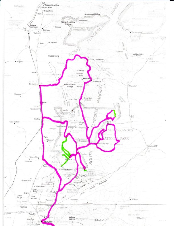
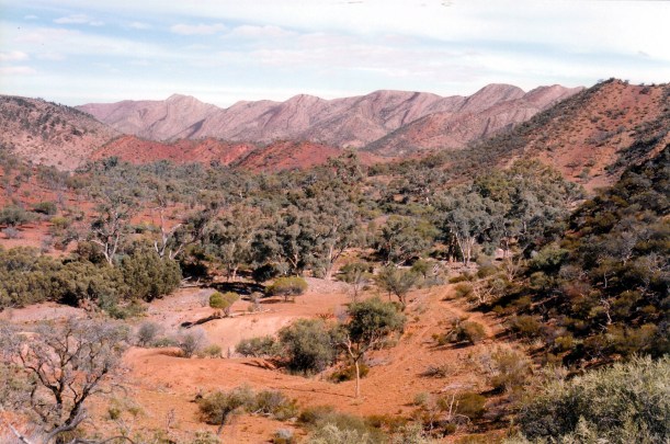
Our route to Copley. Artimore is in the folded ranges north of Blinman


Leave a comment

1999 Travels May 18

TUESDAY 18 MAY     WILPENA

We woke up a bit stiff after yesterday. This was surprising, because we have been doing a lot of walking. Must have been due to the gradients, I think.

We decided that a drive would be a pleasant way to spend the day, which is our final one here, for this trip.

We drove the Bunyeroo Gorge road again, with its superb views. Continued north from Bunyeroo Gorge, to intersect with the Brachina Gorge road. Drove west through Brachina Gorge, in places driving in the pebbly bed of the dry creek. Kept going on the track to meet the sealed Leigh Creek road, on the western side of the ranges. Drove north to Parachilna , then followed the unsealed road and track back east through Parachilna Gorge. We turned left just through the gorge to go have a look at the Glass Gorge and find somewhere pleasant for lunch.

The Glass Gorge track was the route used, until 1889, to cart copper ingots from Blinman to the railway at Parachilna. It follows a very winding creek bed.

05-18-1999 02 on Glass Gorge PAR.jpg

The Glass Gorge Pastoral Access Route

Ate our lunch in the dry creek bed.

I had thought that we would continue on to Blinman and return to camp from there, but John decided on the spur of the moment – at nearly 2pm – to drive the Public Access Route to the Artimore ruins, to the north. This was just because I casually mentioned that it was there, and what a great idea these Public Access Routes are. I also said it was “too late this time – another time”. Me and my big mouth!

We took the track past “Moolooloo” and turned right where it was signed. Drove through the Hannigans Gap and along the Gap Creek valley and gorges. It was excellent scenery and somewhat challenging driving. The gorges were much better than those we had been through on the Skytrek route.

05-18-1999 03 Wearing Gap on Artimore tk

The PAR track in Hannigans Gap

We stopped and collected a small cypress pine log from there, to become woodwork timber and some sort of permanent souvenir.

After Hannigans Gap it was slow going, with lots of little gullies and channels to negotiate.

05-18-1999 04 Oratunga Ck valley

The PAR track in the Oratunga Creek valley

We reached the Artimore ruins. This was established as a sheep station in the 1850’s, but abandoned in the early 20th century, due to drought and the ravages of wild dogs and rabbits. Clearly, in its time, there were a number of quite substantial stone buildings here. There was enough left of these to make the drive worthwhile – and they were in a superb setting, in a valley amongst the rugged ranges.

05-18-1999 05 Artimore HS ruins.jpg

Artimore ruins – possibly the main homestead?

05-18-1999 07 artimore ruins.jpg

This may have been the workers’ quarters?

05-18-1999 08 truck and ruins

The Artimore ruins in their rugged setting

05-18-1999 09 Artimore old building

The workmanship is evident in this ruined building at Artimore

After looking around the ruins for a time – too short – we continued on. On my not very detailed map, a track was shown going south to the Blinman road. But there was a track junction not far from the ruins, and I was not sure which way to go. There was a rough  Orantunga Station sign, pointing one way. We remembered the Willow Springs people saying that Orantunga had set up something similar to Skytrek, so thought we had better not go that way.

After quite a lot of very tense and rather rough kms, we came to a PAR signed gate, and knew that we were not going to end up in nowhere, or at a locked gate! We were unsure of the distance we still had to go, it was getting late, and it had been threatening to rain all day. We had only had a few drops, but the sky was dark.

We were very relieved when we then quite quickly reached what looked like the Angorichina road, turned right, and soon after met the Blinman to Wilpena  road.

On the way back stopped at Stokes Lookout to watch the sunset – it was that late!

We got back to Wilpena just after dark, having driven 229kms.

Despite the anxiety at times, it had been a great day. One of John’s “little adventures”, and one which ended better than some!

Tea was packet soup, and a quickly made pasta, tomato and tuna dish – very good.

05-18-1999 in the Flinders.jpg

Our driving and walking routes in the Flinders Ranges, whilst we were based at Wilpena


Leave a comment

1999 Travels May 17

MONDAY 17 MAY     WILPENA

Got a fairly slow start this morning, as I still had the cold.

Decided we would tackle the other end of the Wilkawillina Gorge walk, so packed lunch and set off to drive to the Little Bunkers Trailhead. Continued on the Wirrealpa road for about 6kms past where we had turned off for the other trailhead, then found the track to the north. Followed this track for about 7kms, up a narrowing valley and parked Truck at the track end. There were quite rugged ranges all around us here.

Ate our lunch by Truck – the last of John’s yummy pasties.

It was about 1.15 when we set out walking.

The track initially climbed up a range – a steady climb, angling along a very steep hillside. The track itself was very narrow – like about a foot wide in parts – and the drop off was steep. It was somewhat stressful for me because of the height and the drops alongside the track. There was only low grasses and small shrubs on this limestone and siltstone slope, so the openness accentuated the perils.

05-17-1999 01 sth bunkers-wilkiwillina gorge tk.jpg

The narrow track up to the saddle – note my uphill lean! The track is evident, crossing the slopes behind

After 2kms of climb, we reached a saddle – great relief on my part, because the land on both sides of the track went up! There were excellent views from the lookout there.

05-17-1999 02 almost to the top

In the saddle. The lookout is on top of the hill.

Then we continued on, down the other side. There was some loose rock in places on the path, and one had to watch their step, but it was not as vertiginous as the other side.

05-17-1999 03 walk track to Wilkawillina Gorge

The track from the saddle towards Wilkawillina Gorge

05-17-1999 04 j on track down.jpg

The track down towards the Gorge was easier – and better vegetated

At the base of this slope, we reached Wilkawillina Gorge and Ten Mile Creek. It was just brilliant. The creek bed is wide. The gorge is steep sided. There is a permanent waterhole, with bright green bulrushes.

05-17-1999 06 wilkawillinia gorge.jpg

In Wilkawillina Gorge. Boulders of red sandstone and white limestone show the two adjacent rock types of the Gorge

We followed the creek back through the gorge to the creek crossing at the 6.4km mark, according to the track notes. Since these start from the northern end it meant we’d walked 5kms since we started, as the total walk length is 11.4kms.

05-17-1999 07 wilawillina gorge

We followed the creek bed through the Gorge

It was about 3.45 by now, so we needed to turn around and back track – and make a fair pace.

John managed really well. It was a hard walk on the legs and feet. This walk is rated as Hard.

05-17-1999 05 Wilkawillina three mulga trees.jpg

I was intrigued by these three dead mulga trees by the track

The track back down from the saddle was just as bad, going down. Once we could see Truck, a long way below, we abandoned the more gradual track that wound around the slope, and walked straight down a side ridge. It was very steep, but, paradoxically, easier for me than the giddy parts on the track.

05-17-1999 08 track down from wilkiwillina gorge.jpg

Heading back down. Truck is parked by the road track, on the far side of the creek gully

Reached Truck at 5.15pm.

It was dark by the time we got back to camp, having driven 107kms for the day. We were both really weary.

The cold seems to have eased somewhat – just have a bit of a sniffle. Maybe I have walked it out?

Tea was a packet soup, toasted cheese, yoghurt and pear.

Early night again.


Leave a comment

1999 Travels May 16

SUNDAY 16 MAY     WILPENA

John had said that he wanted to make Cornish pasties this weekend, so we’d bought mince in Port Augusta. He had to make the pastry from scratch, and worked most of the morning, to make six pasties. They were excellent!

We had some pasties for lunch – with a bottle of red wine, for a change. Drinking wine at lunchtime is most unusual for us!

After the large lunch, we needed a walk, so followed the track to St Mary’s Peak that runs along the “front” of the range from the Wilpena camp ground. Walked for 90 minutes along this, almost to Tanderra Saddle, then retraced the same way. It was good exercise.

I started to sneeze on the way back, then had a streaming nose for the rest of the evening. That came on so suddenly. Maybe I picked up a cold germ when we were in “civilization” on Friday?

Tea was pea and potato soup, more pasties, yoghurt and banana.

I went to bed early to try to sleep off the head cold.

05-18-1999 11 flinders sunset.jpg

Dusk in the Flinders Ranges


Leave a comment

1999 Travels May 15

SATURDAY 15 MAY     WILPENA

We spent a quiet morning, reading the Saturday paper, which was available at the shop here.

I made a pea and potato soup, using up the tin of peas I have been trying to get rid of since we were in North Qld, last year. It was an emergency supply – we do not usually eat tinned peas.

After lunch, decided to go for a bike ride. Thought we’d tackle some of the Mawson Trail – a long distance trail for cyclists, similar to the Heysen Track for walkers. In places, they are one and the same, and this is the case from Wilpena, north towards Wilcolo/Bunyeroo.

The track was pretty rough in parts, with loose shale, precipitous gullies, and winding in amongst the trees. It required much concentration and lots of gear and brake work. I was pleased that I hadn’t risked bringing the camera.

I scraped my shins when I missed a gear change up out of a gully and the bike rolled back on me.

A bee flew into the back of my head, below my bike helmet, got tangled in my hair, and stung me! I wasn’t having a great day, at this point!

However, the ride was very scenic – when one had the chance to look. Yet again, it is getting away from other people that is part of the attraction. We reached almost to the Bunyeroo Gorge road.

We decided to return via the much easier management vehicle track, rather than stay on the worst of the gully and loose rock areas shared with the Heysen Trail. We thoroughly enjoyed that section of the ride – easy going, and we could look around. It came out at the old Wilpena Homestead, now unused, I think, but still looking quite substantial. Then we came out on the approach road to Wilpena and had to start watching out for cars again.

It was late afternoon when we got back to the van. We had ridden 18.2kms.

Tea was the pea soup – and it was very nice. It was followed by a chicken casserole, adapted and cooked in the electric frypan. That was pretty good, too.


Leave a comment

1999 Travels May 14

FRIDAY 14 MAY     WILPENA

We got up at a sensible hour, with the help of the alarm, and set off at 9am to drive to Port Augusta. We had things to do that required an urban centre.

We passed through Quorn, which looked a pretty place, and through the Pichi Richi Pass. We will have to explore these places properly, sometime.

We were passed by many Landrovers, going north, for a big Jamboree weekend at Blinman.

When we got into mobile phone range checked the phone and found a message from friend A, from Caramut.

We went to the bank in Port Augusta, to transfer money to pay for the shares John bought. This was the main reason for our visit. I got some photos developed and printed.

Being Friday, we had our fish and chips as lunch.

Went to Coles where I stocked up with lots of fresh vegetables and fruit, in particular.

Refuelled Truck – 68cpl. That is a lot cheaper than at Wilpena!

We drove over the main Port Augusta bridge, that takes the highway to the west and north, for old times’ sake. We walked it so many times in 1993, when we were stuck here for the best part of a week, while the Hilux had a broken axle repaired. Then we drove back across it!

On the way back to Hawker, overtook a Defender and an older Landrover County, obviously travelling together, and obviously Landrover aficionados. We talked with them on the CB – they are a husband and wife. Then we talked in person, when we all pulled into the Rest Area at Hawker. They are very experienced travellers – especially her. The Defender was pulling an offroad camper trailer. It was a fun encounter.

In discussion about our next move, as we were going along, we decided to give Arkaroola, in the northern Flinders, a miss this time. We have been there before, and whilst it is well worth visiting again, there is the lure of places we have not yet seen.

Back at Wilpena, I phoned home and asked P to send the mail on to Leigh Creek.

I phoned E and A. They wanted to tell us that they are interested in doing a Simpson Desert crossing with us – but next May/June. I am not sure that will suit us, though. They are going to visit family in Qld this year. E expressed an interest in returning down the Sandover  “Highway” – the unsealed route from NW Qld to Central Australia – as that is one way they haven’t been. I said we’d let them know about all that.

The campground has become very busy – it is a long weekend in SA.

Tea was tinned asparagus soup, some salad, and yoghurt.

We drove 342kms today, essentially just to visit the shops!


Leave a comment

1999 Travels May 13

THURSDAY 13 MAY    WILPENA

The day got off to a fairly slow start, after John stayed up really late, playing his game.

We decided to walk part of the Wilkawillina Gorge Track. The information about this walk made it seem interesting, and it was one we had not tackled in prior visits. We had seen the country around that area from a vantage point on the Skytrek drive. It is still within the general area of The Bunkers ranges.

If we’d had two vehicles, could have put one at each end of the walk through the gorge, and done a shuttle, to avoid retracing our steps. But we don’t – so decided to tackle the northern end of the walk, and do about half of the track – both ways!

While John was getting organized, I cooked up some potato for tonight’s tea, expecting that we might be a bit late back. Made lunch.

Drove back to the main road and turned north again. This time we stayed on the unsealed Blinman road, past the entrance to Willow Springs, and took the right fork – the road to Wirrealpa. About 40kms from Wilpena, found the track north to the Mt Billy Creek Trailhead, drove the 7kms to this and parked Truck.

We ate our lunch at the car park at the Trailhead, at the start of the gorge track. Spotted a spiny cheeked honey eater in some bush by the creek.

05-13-1999 02 Bunkers Ra from walk tk.jpg

The terrain and walk track, just after starting the Wilkawillina Gorge walk

We walked to the 4.2km mark, through interesting and varied terrain. There were some excellent waterholes in the Ten Mile Creek that goes through the gorge.

05-13-1999 07 permenent waterhole Wilkawillina Gorge.jpg

Waterhole and bulrushes in Wilkawillina Gorge

In general terms, this eastern side of the Flinders is drier than around the Heysen Range and Wilpena, so there is mulga rather than the cypress pines of the country we were in yesterday.

05-13-1999 03 Mt Billy Ck

A dry section of Ten Mile Creek in Wilkawillina Gorge

05-13-1999 05 Wilkawillina walk scene.jpg

Arid slopes beside Wilkawillina Gorge – and dead mulga

The rocks in this area are a mix of sandstones and limestones – the latter more white than red. In one place we could see water ripple marks, made when this was deposited under an ancient lake or sea bed.

05-13-1999 08 Wilkawillina wave patterns.jpg

Ripple patterns in limestone rock

At the 4.2km mark – we were following track notes, so we knew where we were – it was time to turn around and retrace our steps, to make it an 8.4km walk in total.

05-13-1999 04 walking to Willkawillina Gorge.jpg

Wilkawillina Gorge country

05-13-1999 09 late afternoon in Bunkers

Late afternoon on the Wilkawillina Gorge track

Before we left camp, I’d persuaded John to try walking in the HiTec boots that were Dad’s. I’d brought these with us to use myself. He found them comfortable – no problems with blisters in these. Dad would have been pleased!

It was just about dark by the time we got back to camp, having driven 97kms.

Tea was pumpkin soup, followed by salmon cakes.


Leave a comment

1999 Travels May 12

WEDNESDAY 12 MAY     WILPENA

The sky was blue again this morning. Sod’s Law! There was some cumulus cloud build up during the day, but it remained clear enough to see the stars at night. They are absolutely brilliant up here.

After breakfast, John did some share arranging, going to the phone to call our broker and buy a tech stock he likes, with the improbable name of Sausage Works. He used his “share” of the proceeds from the Telstra ones I sold.

He refuelled Truck – still 81cpl.

I cleaned the van out, made lunch, wiped the dust from yesterday from the interior Truck surfaces – there was lots of it!

We went for a drive up the Bunyeroo Valley. Drove back to the main road, turned north (the road is unsealed from this point)  and a few kms on, took the Bunyeroo Track to the left. We stopped at the Yanyanna old stock yards and huts and looked around, before continuing on.

05-12-1999 01 heysen range from stock yard and huts

Outlook at the old stock yards and huts – Yanyanna

This part of the Flinders has got to be the most scenic part of the whole area – there are superb, panoramic views from lookouts and road bends along the road to the Gorge.

05-12-1999 02 Bunyeroo panorama RHS

ABC and Heysen Ranges from a lookout on the Bunyeroo Gorge Track

05-12-1999 04 bunyeroo rd and heysen range.jpg

The Bunyeroo Gorge Track and the Heysen Range

We ate lunch down in the bottom of the valley, beside Bunyeroo Creek. Did some bird spotting.

John used the Radphone – which he’d arrranged to have connected again, from yesterday, to call both brother C and sister H. He was pleased that the HF radio seems to be working well. It was a good, clear connection. We will be relying on it more and more, now.

I was looking for the walking track along the Bunyeroo Gorge, and couldn’t find it. Turned out we were not far enough along – it was annoying. My map did not seem all  that accurate.

Eventually we drove along a bit further, parked Truck, and walked for an hour south along the Wilcolo Track. This was pleasant walking, initially beside a creek bed, then through an area of cypress pines. There were excellent view of the Heysen Range, to start.

05-12-1999 07 Bunyeroo Wilcolo walk.jpg

Cypress pines growing along the Wilcolo Track. Despite its width, there is no public vehicle access.

At the end of an hour we turned and retraced the way, and then the views of the ABC Range were great. As we walked, we saw kangaroos, goats and emus. Stopped periodically to look for birds. All up, we walked about 7kms.

05-12-1999 09 walk track bunyeroo wilcolo tk - st marys peak.jpg

Late afternoon on the Wilcolo Track

Drove back to Truck the way we had come. Got back to camp about 5.30pm. We drove 63kms today.

The hot shower was very welcome.

Tea was pumpkin soup, beef stroganoff with pasta.

John was not as tired tonight and sat up late playing his alpha centauri game. I went to bed quite early.


Leave a comment

1999 Travels May 11

TUESDAY 11 MAY     WILPENA

We needed to get a reasonably early start. Woke to a sky that was grey and cloudy – and which became more so as the day went on. It was a real pity that we did not have the clear and sunny weather of the past few days, for today.

We drove to Willow Springs, paid, and collected the key about 9.30 am. All the information says that at least six hours must be allowed to do the circuit. They will not issue a key after 10.30am.

The charge for a vehicle to do the Trek is $30 – but we only paid $25, due to “local connections”.

We received a nicely presented folder with information and track notes. The drive is about 80kms; there were 40 points of interest marked on the map. Some of these related to specific vegetation and natural features like springs, some were to do with the station operations, like bores and gates. We had no trouble following the map and finding our way.

05-11-1999 01 Willow Springs.jpg

Willow Springs

Our first stop was at the Willow Springs, through the Gorge, where we looked for birds, admired the scenery – and watched sheep in the distance playing at mountain goats!

05-11-1999 03 Bullock Bush stock pruned.jpg

Bullock Bush grazed up to head height by stock

05-11-1999 04 zebra finches

Zebra Finches near Moxans Hut

We had a sausage and bread BBQ lunch in a dry creek bed past Moxans Hut, which we’d seen the other day. It was built in the late 1800’s and housed the station worker until the 1960’s. He must have liked solitude! John enjoyed doing the fire lighting and BBQ thing. It was all very pleasant, apart from there being lots of flies. We made sure the little cooking fire was put out with some of the water we carry.

05-11-1999 10 Skytrek parked for lunch.jpg

Lunch place


05-11-1999 08 gums and bunkers.jpg

Old river red gums – so typical of the Flinders Ranges

We had initially proceeded east from the station homestead, then north, travelling parallel with ranges on each side. Then we reached the northern most point of the Trek and where we were advised that 4WD must be engaged. This is easy on the Defender, as it is just a lever and one does not have to worry about getting out and messing with wheel hubs.

05-11-1999 06 The Bunkers.jpg

The Bunkers

From this point the going was steep in places, very twisty, and there were some loose surfaces. But we felt quite safe, throughout, and did not think that it was actually all that difficult to drive. There were incredible views as we climbed.

05-11-1999 12 looking back across bunkers trk.jpg

The track rising – looking back the way we have come


05-11-1999 15 Skytrek view to NE.jpg

Sky Trek track winding down over the ridges, into the distance

The rise up to Mt Caernarvon (920metres) was steady and steep, but the ridge was quite broad, so it seemed very secure. It was a bit hard to believe that we had driven to the top of the second highest peak in SA!

05-11-1999 19 Over Loves Mine Ra to Heysen Ra & St Marys Pk.jpg

From Mt Caernarvon, looking over Loves Mine Range, towards St Marys Peak

We parked beside the track – just in case there was someone coming behind us – though we had not seen anyone else all day. At the cairn on top of Mt Caernarvon, signed the record book that is kept in a tin there. Wandered about a bit, took photos.

05-11-1999 21 j on mt caernarvon.jpg

Signing the Visitors Book on top of Mt Caernarvon

On the top of the ridge there were stands of grass trees, which were quite dramatic with the sky as background.

05-11-1999 22 grass trees.jpg

Grass trees near the summit of Mt Caernarvon

By the time we were coming down the ridge – steep in places, but not scarily so – it was 4.30pm, and the light for taking photos was getting dull. We stopped at the homestead to turn in the key.

The Skytrek was really worth doing, and worth the money. It was an exhilarating day. We will remain grateful to J and U for introducing us to it – I doubt we would have known anything about it without their help.

05-11-1999 11 Skytrek track winding away.jpg

Sky Trek – the track winding over the closer ridges, then just seen climbing over a far saddle

We got back to the van at 5.30, having driven 111kms.

We sat in Truck, listening to the news, until 6.15. Also reported ourselves into the 4WD Radio Network Adelaide Base, and listened to their sched session for a while. We drank beer and ate crisps during our radio session.

Then we went for showers and had a light tea: biscuits, cheese and apples.

After tea, we both felt really exhausted – and decided that it had been a really tiring day, after all. We both crawled into bed at 8.45pm!  And slept for twelve hours!

It was a warmer night than previous ones, due to the cloud cover. There were a few spits of rain on the roof during the night.


Leave a comment

1999 Travels May 10

MONDAY 10 MAY     WILPENA

John wanted a rest day, today, since we have been active every day since getting here.

It was another beautiful blue sky day. Yesterday, U had commented on the unusual clarity of the air and the views – so it is not always like that, here.

I did the washing.

Basically we just lazed around for much of the day. Read some accumulated newspapers and some travel guides. I did some knitting.

I walked to the office and paid for another week’s accommodation here. There is still so much that we want to do.

After lunch, we went for a bike ride, as far as the old hut and the Cazneaux Tree. We detoured to the solar farm lookout. The solar farm consists of rows of solar panels generating electricity that can be used at Wilpena, which is not on the main power grid, and has relied on its own diesel generators. The SA Govt had the solar farm installed, to demonstrate what can be done with this technology. It only started operating a few months ago. The rows of panels are in a slight valley, so they are not really noticeable unless one goes to the lookout. The experimental work that is being done on a solar power supply, here, is impressive. The way of the future?

Our 15.5km bike ride was very enjoyable – such a great setting for cycling.

The camp area was nice and peaceful in the morning, but by mid afternoon it was filled with vans.

John went to the public phone at the office (no mobile reception here) to make some calls. He contacted our sharebroker to check on some share prices. Phoned Hayman Reece to ask about the advisability of taking off the weight distribution bars on rough roads – we should! He also phoned and booked us to do the SkyTrek tomorrow.

A park worker, whom John had encountered somewhere about the place, came by after work to talk to John about web sites and his plans to set up a business offering abseiling and climbing, here. He did not seem to have much idea, though, about things like liability insurance, so I think he has a lot of learning to do yet.

Tea was late – due to our visitor. Pumpkin soup, Hawaiian tofu stir fry and rice – was ok.

We are having a good run of early nights – must be the unpolluted air here.