This Adventurous Age

Adventures travelling and working around Australia.


Leave a comment

1999 Travels September 6

MONDAY 6 SEPTEMBER   MT IVE STATION

Today was a pleasant one, not too hot, with some cloud and some sunshine.

We obtained a mud map of station tracks, when we booked in yesterday.

Were able to top up our fuel with 20 litres here – 86cpl.

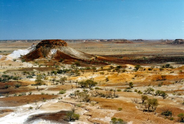
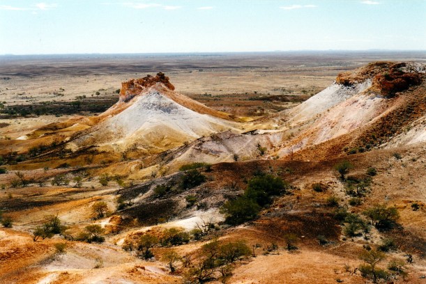
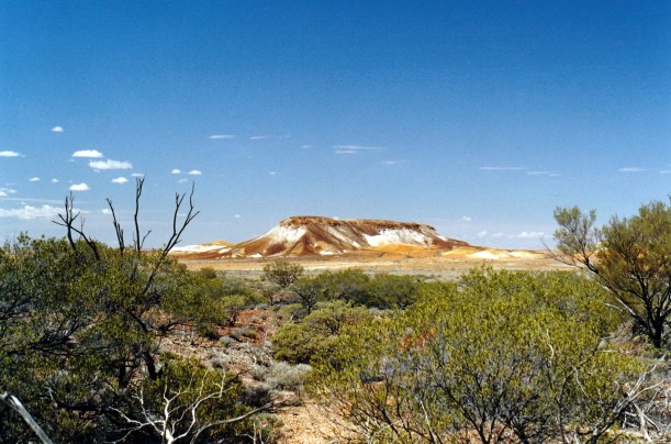
Our first destination today was Kath’s Castle – a columnar rhyolite rock formation – which means pillar like shapes. The track was narrow, but not too rough. From its end, we walked up a small, dry, creek bed to reach the wall-like formation.

09-06-1999 01  scene from Kaths Castle.jpg

Kath’s Castle

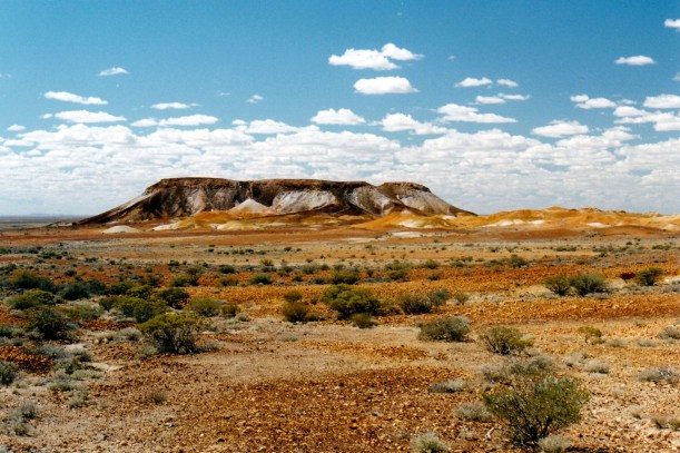
We then climbed the hill beside Kath’s Castle, to see what the view from the top was like. The walk was longer than we’d anticipated, as the skyline was further than it looked!

Along the way, disturbed a number of wallabies and euros or kangaroos – I still can’t tell the difference, much of the time. We saw where they make circular “nests” in the spinifex that was prevalent through here.

09-06-1999 02  roo nest.jpg

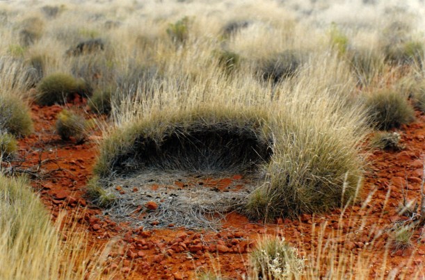
The nest of a wallaby or euro in the spinifex

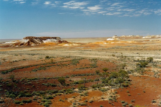
The view from the ridge was worth the effort. There were good views over the distant Lake Gairdner.

09-06-1999 03  view from mt gairdner.jpg

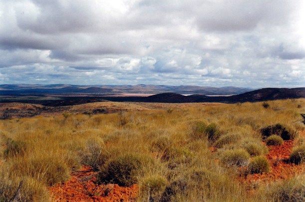
The outlook from the ridge behind Kath’s Castle

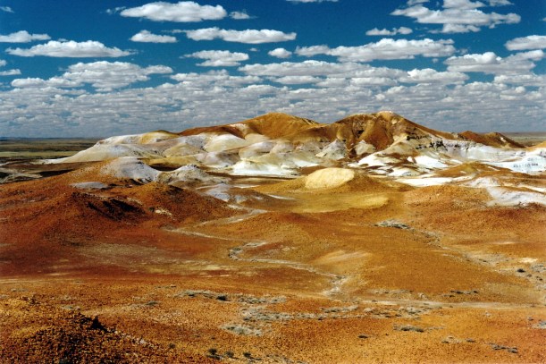
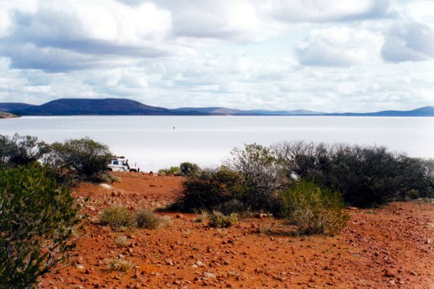
Clambered back down to Truck and drove on to Lake Gairdner. This was so surprising and so brilliant that we had some difficulty taking in what we’d come across, by a chance reading of a snippet in a magazine.

09-06-1999 05  lake gairdner.jpg

Lake Gairdner

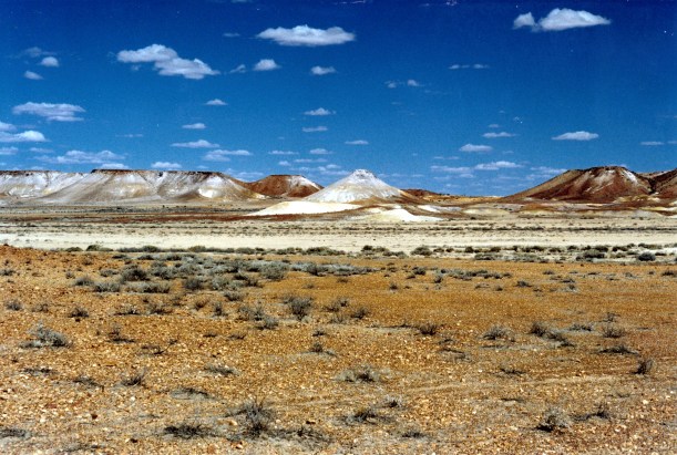
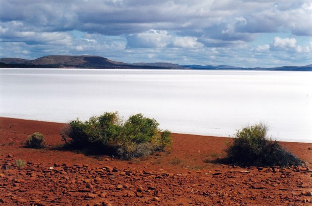
Lake Gairdner is a huge, brilliant white, dry, salt lake. On a map, it looks nearly as big as Lake Eyre, and is, in fact, Australia’s third largest salt lake. Yet we had never before heard of it! It is really beautiful and certainly should be better known.

09-06-1999 lake gairdner view north.jpg

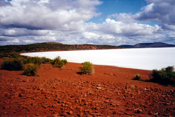
Looking north – Lake Gairdner receding into the distance

With its red shores, and low hills surrounding it distantly, and the really white surface, it is much more scenic than Lake Eyre.

09-06-1999 12  Lake Gairdner panorama 1.jpg

The contrasts of Lake Gairdner

We sat and ate lunch, just taking in the outlook over the Lake – in all directions.

When the sun came out from behind clouds, interesting light effects were created on the salt surface of the Lake.

09-06-1999 06 on Lake Gairdner looking nth

Sun shining through a hole in the cloud, onto the Lake surface

We spent some time on the Lake – walking on it and taking photos. The salt crust is about a metre thick, though in places some underlying red earth outcrops through the salt in some more shallow sections.

09-06-1999 07  wendy on.jpg

This lake is vast….

09-06-1999 10  Lake Gairdner surface detail.jpg

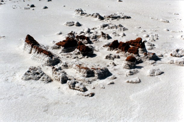
Salt grains encrusting an outcrop of red earth, on the lake

The sand grains are coarse and the patterns they make are interesting in themselves.

It was an absolutely fascinating, impressive place that will remain a highlight of our travels.

09-06-1999 11 Lake Gairdner John in distance

The dot out on the Lake is John walking

Our final destination for the day was an old rock wall dam, built across a little creek valley by the early pastoralists. It showed great craftsmanship in the stone wall construction, worthy of somewhere more significant than this old sheep property.

09-06-1999 17  old dam mt ive.jpg

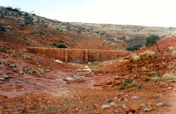
Dam wall on Mt Ive Station

09-06-1999 18  Mt Ive old dam detail.jpg

John inspecting the workmanship of the dam wall

We walked up the dry creek valley for some distance and saw numbers of wallabies, euros and a small herd of goats. It was, therefore, a very smelly creek bed!

09-06-1999 dam valley

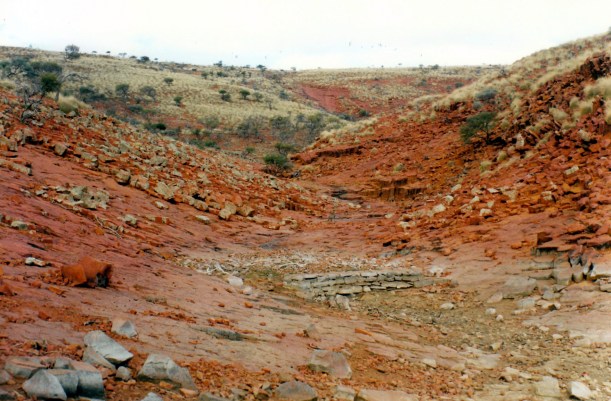
Dry valley behind the dam wall – with goats

We drove a total of 81kms today, on station tracks that were fairly slow going and sometimes rather rough and stony.

09-06-1999 20  Mt Ive kangaroo drinks.jpg

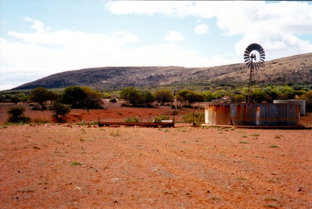
Water from underground – windmill, tanks and drinking trough, with kangaroos drinking

Tea was soup, BBQ steak, baked potatoes and vegies.

What a full day we had! What a wonderful place we stumbled upon!

09-06-1999 19 gawler range wildflowers


Leave a comment

1999 Travels September 5

SUNDAY 5 SEPTEMBER   WOOMERA TO MT IVE STATION  419kms

Today was much less windy, and also cooler.

We left Woomera about 9.15am, after getting fuel – 80cpl.

We had to retrace our route of a couple of days ago, back north up the Stuart Highway, for the 115kms to Glendambo, which was a bit tedious. We noticed puddles of water beside the road, where there had been none of Friday.

Topped up the fuel at Glendambo – 89cpl. That says something about the nature of roadhouses on main highways!

Then we were on to new ground again, heading west to Kingoonya, through rather flat and dull country. The road was a reasonable gravel surface. Just before Kingoonya, we merged with the main Perth and Alice Springs railway and had to cross it before we got into the township. This is a battling little place, once a centre for local farming and for railway workers, but the latter were relocated and the place is heading to be a ghost town. There was no reason for us to stop there – it has no fuel supplies.

We took the dirt road south, and the country almost immediately became more interesting, with some hills. At first, these were mostly low dunes, but further on became rocky hills. We passed a number of salinas – salt lakes and salt pans. The way took us between the large salt lakes of Lakes Harry and Everard, to our west, and the large Lake Gairdner to the east, but we did not see much of these.

09-05-1999 01  Lake Everard by Kingoonya rd.jpg

Dry Lake Everard, beside the road from Kingoonya

It was – rather surprisingly – sheep country, and we passed lots of those. There were structures that we thought were shelter sheds for the sheep, at drinking tanks – later, I read that these were roofs to collect water and funnel it into these tanks.

09-05-1999 02  pastoral relics near Kangaroo Well .jpg

Pastoral relics near Kangaroo Well

The vegetation varied a lot, between the sandy and rocky sections, and with a lot of blue bush.

We did not see any other traffic, south of Kingoonya, so our drive felt very remote.

We stopped to have lunch beside the track, south of Kokatha Homestead. Even homesteads are scarce on this route – we passed by three. While we were eating, I had a bit of a wander around, and gathered some dried kernels from a bush that had red fruit. The kernels have a pitted surface, and could make unusual jewellery. Later, I found out that these were the seeds of the quandong, or native peach.

This was quite an interesting drive, overall. The roads stayed reasonable.

There were occasional spots of rain, and quite a lot of cloud.

We reached Mt Ive about 5pm. The homestead is at the northern edge of the Gawler Ranges, which trend NW to SE through this area. The Ranges were discovered by Eyre, in his explorations westwards, and named for the then Governor of SA.

09-05-1999 mt ive entry.jpg

Entering Mt Ive

Mt Ive is also at the southern edge of Lake Gairdner. It has been a sheep grazing property for over a hundred years. The homestead looks old, and we thought the place, overall, looked rather untidy.  It cost us $15 a night to camp, with power, flush toilets and warm showers. We booked in for two nights.

There was not much choice about where to set up, as there was only one power pole. So we parked in a bay delineated by rows of old tyres – not very scenic!

09-05-1999 03 mt ive camp

Our camp site at Mt Ive

There is a real conglomeration of buildings here – some old stone ones, but also a big building brought from Maralinga (the former settlement at the atomic testing range in the desert). I made a joke to the lady who booked us in, about radioactivity, only to be told that it did register some!

Power is from the homestead’s generator, which provides “background noise” to the camp.

The van’s contents had been a bit shaken up by the rougher roads, and there was a very fine film of dust on the surfaces. Just needed a quick dust and sweep. The scupper vent does a pretty good job of keeping dust levels inside right down.

The freezebox door had come off in the fridge; the meats in there were still frozen, though. John fixed the door. He did the radio sched to Adelaide base.

Tea was tinned soup, a packet pasta with its own sauce, and salad. Quick and easy.

We have decided to explore some of the private station tracks tomorrow.

It was a chilly night.

09-05-1999 to mt ive

Our route to Mt Ive


Leave a comment

1999 Travels September 4

SATURDAY 4 SEPTEMBER     WOOMERA

It remained windy all night, but did seem to lessen off somewhat towards morning. The night was warm enough to not need the doona, but it did get a little chilly by morning, and got progressively colder through the day.

We drove to the shops. Got fuel – 80cpl. I bought bread, a paper, a lottery ticket.

Drove on to Roxby Downs, about 80kms to the north – on a sealed road, through very flat and featureless country,  with big power lines running beside the road, for some of the way. In places, we travelled through areas of low sand dunes with occasional dry salt pans.

This town was built about a decade ago, to service the new Olympic Dam copper and uranium mine project. The mine workers live here, and various services the mine needs are provided. The actual mine is a few kms away.

Roxby Downs town centre is much bigger than I had expected, and was very busy. I bought vanilla slices to have with lunch. Got to support these remote area shops!

We drove out to the mine area, where – from by the fence and gate – there were buildings to be seen – it is a big complex. But the actual mining is down a large shaft, and so cannot be seen.

From the township, took the unsealed road east, for 30kms, to the opal mining village of Andamooka. As we approached the township, there were the tell tale white mullock heaps, typical of opal fields. The place was rough and untidy looking, which also seems typical.

The lines of diggings seemed to follow the sides of a creek valley. The whole place is very higgledy and hard to navigate. Apparently, there is no local council for here, therefore no rules to be followed, in terms of buildings and development. A lot of the structures are shacks.

We followed signs to the Long Bus opal sales centre – a strange little place, where we had to walk through their kitchen and living room, to get to the opal sales room.

There were some aboriginal artefacts and tacky tourist souvenir stuff for sale, but also some good solid opal and matrix opal.

We had not heard of matrix opal before, and we rather fascinated by it. The opal has formed in little spaces in parent limestone rock. Opal in other places forms in other sorts of rock, where the background colour refracts light through the opal, giving it colour. That is kind of a non-technical explanation! Here, the unusual formation in white limestone causes the colour to be very pale. At some stage, some bright persons discovered that, if matrix opal is “cooked” in sugar solution and acid, the colour is brought out. It shows as little pinprick dots in the rock – most unusual and very attractive. I suppose that, if the limestone structure allowed it, bigger opal areas would show up, too.

09-04-1999 matrix opal

Matrix opal – enlarged

I liked this matrix opal much more than the pale Coober Pedy opal, and bought a pendant, for $300, bargaining it down from $390. It has a browny colour, with the really bright pinpricks of colour in it, but also with a slightly larger chip of opal in it, which makes it really unusual. I loved it, on sight!

J phoned sister H and told her about the opals available here. On her instructions, bought her  a solid opal piece – suitable for a ring, pendant or brooch – for $250.

We ate our lunch, late, at Andamooka, then drove around looking at the township, for a little while. Debated about whether we could find a track that might take us out to the nearby Lake Torrens – a dry salt lake – but decided it was too hard, and headed back to Woomera instead.

It had become quite cloudy by the time we left Andamooka.

Back at Woomera, we visited the display area. John went into the adjacent history museum, which cost him $4. I wandered around, looking at missiles, bombs and satellite launcher displays. I took a photo of the launcher of the first Australian satellite sent into space – the fourth in the world. Its remains were recovered from a remote part of the Simpson Desert. There were Jindivik target planes there, and a Jabiru atmospheric research vehicle. I actually found it all quite interesting.

09-04-1999 bits and first rocket for satellite from woomera.jpg

Assorted Woomera related relics

09-04-1999 remains first rocket for satellite.jpg

Remains of the launcher of Australia’s first satellite

When we got back to the van, we’d driven 288 kms today.

Tea was soup, chilli con carne.

It was a cool evening, still with some wind.

I phoned K from the pay phone in the park, to report our whereabouts and possible plans. John phoned H to tell her about the opal he’d bought. He also phoned a place I’d read about that was setting up a camping ground – Mt Ive Homestead, to establish that they do have camping. We will head there tomorrow.

John reported to Adelaide Base of the VKS network, that we’d be going to Mt Ive, in the Gawler Ranges, via Kingoonya. It is a bit remote, so we thought it wise to sched in.

John spent some time working out and entering waypoints on the GPS, for tomorrow’s trip. Then he played games on his computer till after midnight.


Leave a comment

1999 Travels September 2

THURSDAY 2 SEPTEMBER     COOBER PEDY

Today was a hot day, and a fairly quiet one for us.

We read in the morning.

After lunch, walked around town, browsing in a number of shops.

I went to the Underground Book Shop, where I found and bought, of all things, the latest edition of the Lonely Planet Guide to Tasmania.

09-02-1999 21  underground shop.jpg

John bought two triplet opals, with nice colour, for $50. Coober Pedy opal has a milky white background, with colour flashes.

09-01-1999 20 Coober Pedy scene

Coober Pedy scene – old mines, dugout entrances, mining gear

We spent some time in the Desert Cave Hotel, wandering about and reading the information in their underground corridors – interesting. It is a rather upmarket place.

09-02-1999 18  bits of first truck and breakaways.jpg

The first tree seen in Coober Pedy – made from scrap iron!

We bought fish and chips for tea. Whilst out, John filled Truck – 84cpl.

John’s daughter phoned. They discussed the ceremony to do with her qualification as a lawyer. John feels he should try to attend this, but she did not seem all that keen.

John played computer games till 3.30am.


Leave a comment

1999 Travels September 1

WEDNESDAY 1 SEPTEMBER     COOBER PEDY

Today was hot, with only a little cloud.

We chatted for a while with a Swiss couple, who we’d encountered at Birdsville, with a Bushtracker caravan. They’d then driven down the Birdsville Track to Marree, up the Oodnadatta Track, to Oodnadatta, then come across to here. We had a look inside their van – we have not seen one inside, before. I found it rather claustrophobic and closed in. She was not all that happy with it – found it uncomfortable. It looked very heavy to me, for towing.

I packed our lunch, then we drove to the Information Centre, collected some SA material, and bought a Breakaways Pass, for $4.

The Breakaways are to the north of Coober Pedy – about 35kms away. They are, basically, an area of erosion features – flat topped mesa-like outcrops and stony gibber plains. The flat tops of these and the nearby Stuart Range are because many millions of years ago, the region was an inland sea. After the sea receded, softer areas were eroded; the Range and its outliers were more resistant. Similar to Chambers Pillar, I guess. Because the erosion features look like they have broken away from the Range, they were called The Breakaways.

We drove out there – about 30kms north again, on the Stuart Highway, and then we took a dirt road to the east for about 5kms. From the highway, the Stuart Range appears as a low, flat topped plateau on the eastern horizon. There is no indication of the brilliant scenery to come, until one is right up close.

09-01-1999 01  breakaways first sight.jpg

First sight of the Breakaways

The dramatic starkness, and the brilliant bands of colour really stand out here. We parked Truck and walked for over an hour, following a walking track around the base of part of an  escarpment, and to some viewpoints on its top. It was hot going, on the bare, stony ground. I found it a battle to watch where I was putting my feet – kept wanting to gaze at the unreal formations around me. We did not meet anyone else on the walk, and only saw one other vehicle out here, at all. This is really a little-known attraction of the area – everything seems focussed on opals and the town.

09-01-1999 02  Breakaways from LO2.jpg

09-01-1999 04  on walk tk.jpg

09-01-1999 03 from lo 2

09-01-1999 05  more walk tk.jpg

09-01-1999 07 breakaways.jpg

Back in Truck, drove a short distance to The Castle formation, admired different perspectives and ate our lunch there.

09-01-1999 14  from lo 1.jpg

09-01-1999 16  Breakaways 17.jpg

We returned to Coober Pedy mid-afternoon, via a circuit route, that took us over the Moon Plain – flat, featureless and grey – and along the Dog Fence for a way. The Dog fence is a 2 metre high wire structure, that extends for over 5000kms, and is meant to keep dingoes out of the sheep grazing country of southern Australia. Unfortunately, domestic dogs gone feral probably do more damage to livestock than dingoes, anyway!

09-01-1999 17  dog fence and moon plain.jpg

The Dog Fence

That track eventually met the Coober Pedy to William Creek road (unsealed), and we followed that to the highway, and thence back to Coober Pedy.

We’d had a most enjoyable excursion to some fascinating country.

Went to the public water point and paid to fill our big container, then back at the van, emptied this into one of the van’s water tanks. This was not easy to manage, but we had help from a non-English speaking neighbour in a camper van. Much appreciated, and I hope we were able to convey that.

Had a couple of late afternoon beers with other neighbours – from Brisbane. Told them all about today’s excursion. They had not heard of The Breakaways, but I think we convinced them that it was a worthwhile excursion.

Tea was steak, fries, bacon, with eggs for John and mushrooms for me.

John’s sister phoned and they had a chat.


Leave a comment

1999 Travels August 31

TUESDAY 31 AUGUST   MARLA TO COOBER PEDY   247kms

Getting away was easy, because we were still hitched up. Today would be a comparatively short drive, so we were in no hurry.

It was a straightforward run to Coober Pedy, though quite hot. I drove some of it – John wants me to become comfortable towing the van.

At a roadside stop, John emptied a jerry can into the fuel tank.

08-31-1999 Coober Pedy in distance.jpg

Approaching Coober Pedy

We reached Coober Pedy late morning and booked into the Oasis Caravan Park. $13.50 a night, after the Big 4 discount. The caravan park is alright. There are no taps at sites – understandable where water is so scarce. There was one tap at an outside sink. The showers are coin operated – 20cents for about one minute! Travellers can buy water at the town’s public point – 20cents for about 30 litres. That is a better rate than the showers!

We were set up by lunchtime.

After lunch, went for a walk and explore, which we could do as the park is in town. Just as we set out, the fire siren sounded and a fire truck went racing out. Later, someone said there was a big road accident out of town.

The town seems slightly more ordered than when we were last here in 1993, but the shop front offsets are still higgledy and there are no footpaths. Coober Pedy, is, of course, an opal mining township. As we’d approached the turnoff from the highway, we’d started to see the white dump heaps and occasional blowing machines, that are the signatures of the opal areas.

We walked to the Big Winch Lookout, where there was quite a good view over town, with its dugout homes going into the hillside, and the bare sports oval. There was a gallery at the lookout, and we browsed in this; I bought postcards and magnets.

09-02-1999 19  coober pedy oval.jpg

The bare sports oval and the entrances to dugout homes on the hill


Next, we visited the Old Timer’s Mine – it cost us $5 each, but it was self-guiding and we spent over an hour in their tunnels, shafts and dugouts. It was quite fascinating and informative – and just a little claustrophobic. I do not like underground!

We wandered the long way back to camp, stopping to buy a paper, some cheese, and cucumbers.

Tea was salads and tinned salmon.

It is very pleasant to have warmer nights again – we barely even need the doona now.

08-31-1999 marla to cp


Leave a comment

1999 Travels August 30

MONDAY 30 AUGUST   ALICE SPRINGS TO MARLA   484kms

Our pack up and departure was all routine and without incident, and we left at 9.20am. John had hoped to be earlier, because of a long drive ahead, but we probably didn’t get up early enough.

Detoured to the COR Refinery and got fuel – 76cpl.

Today’s drive was south on the Stuart Highway, which of course, we have driven a couple of times before. The country and the landmarks were familiar.

We stopped for a coffee break at a roadside stop, and again at Erldunda where we bought cold drinks.

The only unusual happening to break the routine of the drive south, was seeing a long freight train on the track parallel to the highway, not long before we reached Marla. We travelled in tandem for a while.

I drove some of the way. This was the first time I’d towed the van on a sealed road, and thus at a greater speed than on dirt roads. It felt fine, but I do not drive as fast as John.

We reached Marla about 3pm. Our powered site at the Travellers Rest there cost $19. I guess they have rather a captive clientele, as it is a long way to the next place – either way. Our site had lawn beside it, which was pleasant, and rather unexpected, out here. We were able to stay hitched up as it was a pull through site.

The rest of the afternoon was spent relaxing and chatting with other travellers. The place became quite busy as the afternoon wore on.

Tea was soup, and macaroni cheese from a packet.

The night was noticeably warmer than we’d had in Central Australia.

08-30-1999 alice to marla


Leave a comment

1999 Travels August 28

SATURDAY 28 AUGUST     ALICE SPRINGS

After breakfast, I went to the Office and extended our stay by a day. It is hard to work out the charging in this place. Now the fee is $19 a day – $17.10 after discount. I am wondering if the person who booked us in, originally, hit a wrong key?

We went and did grocery shopping for the coming trip south. As we are making this up as we go, I am not sure when shopping will be possible again.

John fiddled with the TV booster and aerial, and thinks he’s found a fault. He has been doing this for 18 months! Sometimes the picture is good, sometimes it is bad. Seems to me that this is the way of such things for travellers. Guess I don’t really care enough about TV for it to worry me.

After lunch, John went to bowls.

I washed the van floor and cupboards, also did the floor rugs – by hand, and a lot of hankies!

Read the Age that I’d bought this morning – it is good to have that again.

John enjoyed his bowls, even though there were only three playing. He has been very disappointed with the bowls scene in Alice.

Tea was roast chicken and vegies. Very nice – tonight we have an appetite back.

Watched swimming on TV.

The nights are chilly again – we had a warmer night spell for a little while.


Leave a comment

1999 Travels August 27

FRIDAY 27 AUGUST     ALICE SPRINGS

Today was another warm one.

I got up about 7.15am and went for a walk around the caravan park and nearby surrounds, for an hour. I needed the exercise.

John needed a quiet day and rested for most of it.

V phoned, in the morning. They are in Kununurra, having visited Broome, Derby, Windjana Gorge, Tunnel Creek, Geikie Gorge, Halls Creek. They have just done a couple of weeks of farm harvest work – melons and beans, to help pay for front suspension replacement on the car. She said that harvesting rock melons is hard on the hands! B may have a month of gardening work lined up. Then they plan quick visits to Darwin and parts south, to be back in Melbourne by mid October for V’s school reunion. So, I should actually see her before we sail off to Tasmania.

The gem lady phoned to say the stones were done. So we went to the bank, then to the shop to collect them. The final cost was $603, with the earring settings and work. There were 21 stones in all, including five sets of zircon earrings and one garnet set. The large dark garnet did cut very dark – there is only the occasional red flash to be seen in it. But, overall, they are beautiful things. It is fulfilling to see the products of our hard work turn out so well.

08-25-1999 our stones.jpg

Our faceted zircons and garnets, with the sets of zircon earrings in the centre

John intends to send some to sister H and friend H and he picked those out. The biggest zircon is an unusual brandy colour and I plan to have a ring made with it, one day. It is the sort of colour one would see in an Argyle diamond!

Tea was soup and toasted cheese. We were both not feeling hungry.

We decided to stay here an extra day, in order to see the final day of the PanPacs, on Sunday.

John played computer games till late.