This Adventurous Age

Adventures travelling and working around Australia.


Leave a comment

2000 Travels February 27

SUNDAY 27 FEBRUARY     QUEENSTOWN

It was a bit misty this morning, and we were late getting up.

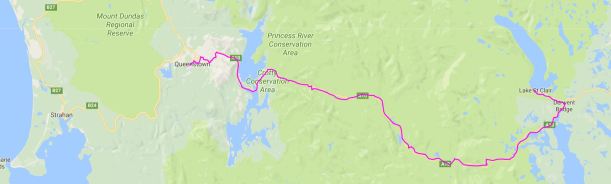
After breakfast, set out for Strahan.

We drove past the caravan park and had a look. It does appear to be in better condition than in ’93, but not by much. There are now some permanent amenity blocks at least. We are definitely better off in Queenstown.

02-27-2000 Strahan shacks.jpg

Strahan houses – colourful!

We spent some time in central Strahan. Booked ourselves onto a Gordon River cruise for Tuesday, as the weather forecast for that day looked ok. Bought a topo map – the Franklin sheet – that covers the Mt McCall area.

I put four rolls of film in for processing at the Kodak shop, after they assured me that their work would be good. I hoped I was not being gullible.

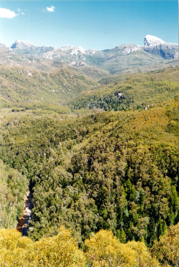
We drove out the King River Forest Drive – out along the Lowanna road beside Macquarie Harbour, then the dirt road alongside the King River. This took us to the old Iron Bridge, part of the former ABT railway, near the Teepookana locality. The road track followed the old rail alignment and was very narrow in parts, and with the King River right below.

02-27-2000 king river nr teepookana.jpg

The King River from the Drive

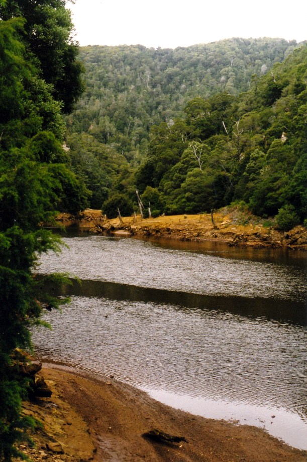
The King River still had the polluted sludge banks evident in piles alongside its channel – from the days when the Mt Lyell Mine and smelter in Queenstown used the Queen River water in their processes, and then discharged the untreated waste straight into the river. The Queen is a tributary of the King. Even though the mining practices have changed in recent times, these rivers are probably the most polluted ones in Australia. The sulphuric acid residues remain a major problem.

02-27-2000 King R Teepookana and mine sludge

The King River near Teepookana – and polluted mine sludge residue

Gold and copper mining began in the Queenstown area in the late nineteenth century, with smelting of copper commencing in 1895. Back then, there were no roads into the region and so, in 1897, a railway opened between Queenstown and Teepookana, near the mouth of the King River. This was to bring the mine products to a port there, for export.

The building of the 3’6″ gauge railway had to overcome major problems. The terrain was mountainous and heavily forested. There were many streams. Cuttings were dug by hand, some up to twenty metres deep. The original 35km long railway had 48 bridges, the longest of which was the “quarter mile” bridge – approximately 250 metres long. They had difficulty finding a firm foundation for this, having to dig down a great distance into the river silt. Even so, trains could only go at walking pace across this bridge, as any greater speed would cause it to sway too much and collapse! It was high up above the river.

The problem of the steep gradient from Queenstown up to Rinadeena siding – 1 in 16 – was solved by using the Swiss ABT rack and pinion system, for some 7kms. The train engine could engage with this central “rail” and pull itself up.

In 1899 the railway was extended from Teepookana to Regatta Point, near Strahan, where the bay was deeper. This necessitated the building of the Iron Bridge over the King River at Teepookana. Later, the railway extended right into Strahan. What had been a busy little port town quickly declined.

02-27-2000 iron bridge teepookana.jpg

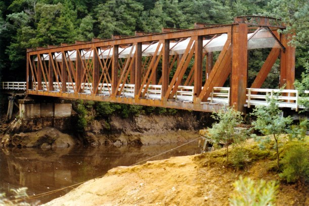
The Iron Bridge, near Teepookana

The first road to connect Queenstown to the outside region was the Lyell Highway, in 1932. In the 1950’s, a road was built between Queenstown and Strahan, and this spelled the end for the railway, as the many wooden trestle bridges were too costly to upkeep, and there were increasing concerns about the Quarter Mile Bridge.

The last train ran in 1962. I was fortunate enough to do the return trip on the railway in May, 1962, and remember the Quarter Mile Bridge swaying quite noticeably as the train crawled over it. The bridge was virtually only the width of the rails, so one looked straight down from the open train windows – and the river was a long way below!

In 1964, with three friends, I walked the disused railway track, camping a night at Dubbil Barrel siding and even riding hand operated trolleys some of the way. These had just been left at sidings when the railway closed! Crossing the Quarter Mile Bridge on foot, high above the river, with no side rails, was very scary!

This bridge was, by 1972, partly washed away by floods and by the 1990’s most of the old track, bridges, sidings and station buildings had fallen down, been burnt in bushfires and overgrown by the lush vegetation of these parts.

Now, the decision had been made to rebuild the ABT Railway as a tourist railway and work was obviously  happening at both ends.

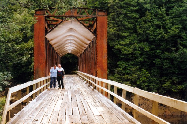
Because of this, the Drive was blocked at the Iron Bridge. It used to allow one to drive as far as the former Teepookana town site. We walked around the fence and across the bridge, with another Victorian couple who had fetched up there at the same time as us. They took a photo for us, on the bridge. When the former rail alignment here was set up as a tourist drive, wooden planking and side rails were added to the bridge, and mesh was slung between the top girders to stop flakes of rusty metal falling on cars and walkers.

02-27-2000 iron bridge mesh

The Iron Bridge altered for road traffic

It was a pity that we could not access the walk to the old Quarter Mile Bridge. Apparently, a tour operator can take customers up to the Teepookana Plateau, for $30 a head. John is not inclined to do that, at this stage.

John found a healthy looking Huon pine tree growing by the King River, and wanted a photograph with it.

02-27-2000 huon pine king r.jpg

John with Huon Pine at the King River

On the drive back to Strahan, we looked at the ABT Railway terminus at Regatta Point, which is being restored. This is where the new tourist railway will terminate.

02-27-2000 regatta pt abt terminus

Regatta Point Railway Station being restored

In Strahan, we went to the huon pine sawmill, and looked at the mill and associated gallery of timber pieces. They had some great products, bowls especially, and some very evocative wax painting by a local artist.

We collected my photos. They were beautifully done. It was not cheap, but he gives a replacement film “free”. For $1 a roll extra, I could upgrade from a 24 exposure to a 36, so I got 4 rolls of 400 speed for, effectively, $4. That shop also had huon pine wood products for sale. I liked the wooden cribbage boards – an idea for John to make sometime for Xmas presents: wooden board, Tasmanian illustrated playing cards, printed game rules, in a box. I also liked the shaped garlic bread dishes, with a natural edged top, about 1cm thick, and naturally curved, hand carved, I think.

At the Strahan bakery, I bought a loaf of damper bread and some rich, indulgent fudge.

After a full day, we drove back to Queenstown. The highway between the towns is 41kms, so it is not that far, but overall we managed 156kms for the day.

Tea was cold roast chook, the damper bread which was very nice, and the fudge which was yummy!


Leave a comment

2000 Travels February 26

SATURDAY 26 FEBRUARY     QUEENSTOWN

There was quite heavy rain during the night, which was pleasant to hear on the van roof. As this very wet west coast area gets almost 100 inches of rain a year, this was no surprise. In the morning there was low, misty, cloud and still some rain. Visibility was poor. The weather did clear, a little, late in the day.

We decided to defer the planned drive until the weather was better, for seeing the scenery – which is the purpose of the exercise, for us.

John went back to bed.

It turned into a van based day. I did some computer letter writing, but did not yet print same. It was good to get a chance to do letters.

03-03-2000 wet day queenstown camp.jpg

Wet and misty day at our Queenstown camp

We drove to the National Parks Office and returned the track key. Collected the papers that I’d ordered yesterday from the newsagent.

Tea was roast chook and veggies. An “in” day gives me time to do such meals.

John phoned K and left a message to send mail here. He also talked to sister H, and R again.


Leave a comment

2000 Travels February 25

FRIDAY 25 FEBRUARY   CYNTHIA BAY TO QUEENSTOWN   98kms

I got up about 8am. There was some mist and cloud just rising off the lake and I took my mug of coffee down to sit and watch it. It really is a beautiful place here, despite the deficiencies of the campground.

We were slow packing up and getting away – John adjusted both van brakes before we left and that involved some fiddling about. It was 11am when we left the campground.

Out on the highway, John thought the van brakes were working better.

The run to Queenstown was straightforward enough, quite winding for much of the way.  We had seen almost all of it yesterday.

Since we were last in these parts, the HEC had dammed the upper King River and created the very large Lake Burbury. The highway follows the shores of this in parts, and one gets interesting glimpses of water through the trees. A long bridge takes the highway across the lake and gives very scenic views both ways of the lake and surrounding mountains.

The final 6km downhill section was not as difficult as I had feared. It was a steady downhill run, but not as steep as the road down into Tarraleah had been. But it was quite winding. We did not end up with smoking brakes this time, though they smelled a bit warm!

That Gormanston Hill descent has some vertiginous drop-offs and being a passenger going down is not much fun.

I was amazed at how much the vegetation has grown back on the once bare hills surrounding Queenstown since the copper smelter closed down in 1969. The early miners cut down the timber on the surrounding hills, for quite a distance. Then the fumes from the sulphuric acid treatment in the smelter poisoned off any remaining vegetation. I first came to Queenstown in 1962 and it was like I envisioned the moon would look – bare and crater like.

On the way through town, to the caravan park, we saw where the new ABT railway station was being built, as part of the project to restore the railway. This was of real interest to me, because the reason I came here in 1962, was to ride on the original train to Strahan, and back, on one of its last journeys.

We had decided to have a look at the Queenstown Cabin and Tourist Park and, if it was reasonable, to use this as our base in this area. Back in 1993, we’d camped at the caravan park in Strahan and it was not a pleasant memory. We really did not want to go there unless there was no alternative.

As it turned out, the park was pleasant enough. The surface of the sites was gravel, but one would expect that here, where even the football oval is gravel! With the high rainfall levels of these parts, even if grass would grow, it would get horribly soggy! There has been an effort to grow shrubs in tubs to screen sites, and the amenities are clean and adequate. $15 a night, with the seventh night free.

02-26-2000 from the cp queenstown.jpg

Outlook from our site at the Queenstown Caravan Park

It had become quite a warm day in Queenstown. We were sweating, doing the camp set up.

After setting up and having lunch, we drove to the central shopping area. The town is in the valley of the Queen River, so is long and narrow, following the valley.

03-04-2000 Gormanstown road from Rotary LO.jpg

Queenstown, built along the river valley. Lyell Highway on Gormanston Hill behind.

At the town centre, we encountered the 4WD Radio Network lady again. She is staying in Queenstown too, having investigated and found Strahan too awful. She and friends are driving the Mt McCall Track tomorrow. John decided we should join them and, after unloading the shopping and me back at camp, went off to get the required key and permit from the National Parks Office, and to wash the underside of Truck – also required – to prevent the spread of root rot. He refuelled Truck – 94cpl.

While John was gone, I did two loads of washing. Put the socks and jocks through the dryer. Hung T shirts and the like outside the van, on lines under the awning. Thought I might need to put them through the dryer tomorrow, to finish them off. It was good to have the dirty wash bucket somewhat reduced.

We found that the mobile phone worked here. There were two messages – one from the bookshop about the ordered book. One from K, whose job at the hotel has changed; in the flurry of his new sales role he’d forgotten to send the mail. For once this was good, because we’d earlier asked him to send it to Strahan.  His message said he’d send it Monday if we let him know where to.

TV reception, apart from SBS, was excellent here, which rather surprised me, with the hills all round.

The water is not drinkable. The park has a rainwater tank.

Tea was bought fish and chips. They were rather greasy, but huge servings.

After tea, John phoned daughter R, as it was her birthday.

A big huntsman spider came into the van, through the partly open pressure hatch, where John had brought the TV aerial cable through. The spider sat on the ceiling of the van – John had to capture and remove it to the outside garden. It was a surprising visitor for this area – I wondered if it had been tucked away somewhere under the poptop roof, since the treed camps of Cynthia Bay or Mt Field. If so, would certainly be out of its comfort zone here!

02-25-2000 to qtown.JPG


Leave a comment

2000 Travels February 24

THURSDAY 24 FEBRUARY     CYNTHIA BAY

Today was a beautiful, sunny, clear blue sky day. It would have been a great day to tackle the Mt Rufus walk, had we waited for better conditions.

This was a driving day. We had decided to drive down the highway towards Queenstown, visiting the various suggested tourist stops in the Franklin Gordon Wilderness Area, along there. It was a lot easier to do this without the van on, trying to fit into small car parks and without the pressure of having to get to a new camp destination at the end.

The road west from Derwent Bridge was initially through heathland and buttongrass country, but we soon got into the forested western country, with the road becoming more winding as we got amongst the mountains.

First stop was to do the Franklin River Nature Walk circuit. This was superb, through the rainforest, and by the Franklin River for some of the way. John tried to take a few photos in the dim, green forest, on a very low speed. The circuit was only about a km, but we did dawdle, enjoying the forest.

02-24-2000 franklin r rainforest.jpg

On the Franklin River Nature Circuit

One could see why this sort of country, across the western part of the island, was so hard for the early explorers and settlers to penetrate.

Next stop was at the car park area at the start of the Frenchmans Cap walk. Frenchmans Cap is a pointed, white quartzite mountain, that one can see in the distance from several places in the west. The walk is a pretty tough, multi-day one, three days at a bare minimum. It is not a walk I have done, although at one stage it was on the to-do list.

From the car park, we walked the first few hundred metres of the track, as far as the Franklin River crossing. The old flying fox that used to be the means of crossing the river has now been replaced by a little suspension/swing bridge.

02-24-2000 franklin r crossing f cap tk

Hikers’ bridge over the Franklin River, on Frenchmans Cap Track

There were some photos, at the walker registration booth, of hikers battling through the nearly waist deep mud on the “sodden Loddon” Plains – buttongrass swamp country. I told John that I remembered parts of the Overland Track being like that, when I first walked it – especially the Pelion Plains. The biggest problem walking in that sort of stuff is that you cannot tell, until foot is planted in it, whether the patch of mud you are entering is a few inches deep, or a couple of foot deep. The boardwalks of the Overland Track are a great improvement!

Back to the highway for a short while, then another car park and the short walk to Donaghys Lookout, from where there were superb views of the Franklin and Surprise Rivers and Frenchmans Cap. We were lucky to strike such a good day – the top of the Cap is often shrouded in cloud and invisible. But for us today, the summit stood out, brilliant white.

02-24-2000 frenchmans cap from donaghys lo.jpg

Frenchmans Cap from Donaghys Lookout

We stopped on the walk track to look for some birds we could hear. While John was standing still, a big tiger snake crossed the path, quite close to him. It wasn’t in any hurry – unlike John – and I was just able to photo its rear end moving off the path.

02-24-2000 another tiger snake departing.jpg

Tiger snake disappearing – John gone!

The furthest point west we went was to Nelson Falls – again, a short walk from the parking area. The Falls were excellent, amongst the best we’d seen, till then, in Tasmania. However, they are on the tour bus route and we did not get much time to ourselves, in there, between bus groups. It was impossible to get enough distance from them to take a photograph that did them justice.

02-24-2000 Nelson Falls too

Nelson Falls

At that point, we were not really all that far from Queenstown.

On the way back, we stopped at the Collingwood River crossing of the highway, which Franklin River rafting parties often use as a setting off point, as the Collingwood runs into the Franklin. The river seemed rather low there now, though. Even this part of Tasmania seemed unusually dry.

We drove 135kms today. It was definitely much easier than trying to visit those places with the van. Some of the parking areas were pretty small.

Tea was sausages. John also had leftover fried rice, and bread with peanut butter! His choice! I has some salad with my sausages.


Leave a comment

2000 Travels February 23

WEDNESDAY 23 FEBRUARY     CYNTHIA BAY

During the night, the wind dropped and rain set in. It eased off towards the morning, but visibility outside was low.

We decided to have a “wait out the weather” day. This assumed, of course, that the bad weather would only last a day! Up in this country, there are no guarantees of that, even in summer. There are a couple of huts on the Overland Track that I’ve been blizzarded into, for days at a time! In summer.

Through the morning, we read the paper and lazed about.

02-24-2000 crow vs wallaby.jpg

Crow investigating what wallaby eating, by our van

After lunch, as the weather was clearing, after all, we went for a walk.

Took the Overland Track to Watersmeet, then a loop that went to Platypus Bay, on Lake St Clair. We returned along the Woodlands Track, to make a circuit of about 5kms. We were out for about two hours, but it was a leisurely walk.

Watersmeet, where the Hugel and Cuvier Rivers join, was really beautiful. The waters of both were rushing over smooth boulder beds, amongst the green of the surrounding myrtle rainforest. Much of the Woodlands Track was also through myrtle dominated rainforest and was rather lovely.

It was good exercise, to walk today, and ease out any stiffness from yesterday.

John took his little portable radio with him, and tried to listen to the Australia Vs NZ One Day cricket, at points on the walk – not very successfully. I was surprised there was any radio signal at all, up here.

Back at camp, we had early showers – to catch the amenities when they were – briefly – clean.

A lady walking past our camp stopped when she saw the 4WD radio network sticker on Truck. She told us her Victor call sign. All members have a call sign with a number; the first part identifies the State one comes from – Victorians are Victor……She travels solo in an ex-Britz hire Troopy, with a pop top. She told us that she sometimes fills in doing relief spells at the radio bases, so it is quite possible we will encounter her sometime, on the radio network. Her Troopy has two spare wheels, on fold out Kaymar frames, on the back. Good way of setting up to carry the extra spare.

Tea was fried rice.

02-21-2000 04 dusk lk st clair.jpg

Lake St Clair dusk

John phoned daughter R, who is still having job interviews. Then he read my share book for a while and played his computer games. I am trying to ration out John’s “Solomon’s Song” to make it last the rest of the trip, so read this week’s quota then went to bed at 10pm.


Leave a comment

2000 Travels February 22

TUESDAY 22 FEBRUARY    CYNTHIA BAY

I got up at 8am, to a cloudy day. Took my morning coffee down to the lake side and sat, watching the water. It was rather windy.

We set off, walking, about 10.30am, to tackle the track to the summit of Mt Rufus. This peak – some 1400m high – is at the “back” of Cynthia Bay. The walk is one I did many years ago, when staying here after an Overland Track walk. It is a circuit of about 20kms – up Mt Rufus, from Cynthia Bay, then back via Richea Valley and Shadow Lake.

We were later leaving than we should have been – story of our lives! The cloud overhead was fast moving, and it did not look to be a promising day for going up high, in these parts. I suggested we walk to Forgotten Lake first, then see what the Mt Rufus summit area looked like from there – in effect, starting the circuit the reverse way. However, John was determined to tackle Rufus today, regardless.

We did not have far to walk, maybe 500 metres, from the campground, along the start of the Overland Track, before coming to the Mt Rufus track, which veered off to the left. Then, it was a steady climb.

There were some really pretty parts, in myrtle forest and the like, with lots of lichen and mossy growths on the trees, which was enchanted forest-like! There was a desolate area, higher up, where bushfire had killed the snow gums, which were just bare, silver trunks. There was one beautiful old, low, tree, half dead but battling on with its other half, really gnarled, with moss and lichen hanging off it. I stopped, admired it, touched it – as a sign of encouragement, I think. I don’t normally do that sort of thing.

02-21-2000 lichen Lake St Clair.jpg

Lichens festooning a bush

As we climbed higher, we came out of the tree line onto rocky, alpine scrub and marsh areas. The wind was noticeably stronger and it was quite cold. The clouds were really racing over.

We climbed up onto the ridge that leads, for over a kilometre, to the summit. Here, the wind was strong enough to make one stagger and lose their footing. It was really hard to walk.

We encountered the couple that we’d met and talked with at the Lake Dobson car park, after we’d finished the Tarn Shelf walk. They were on their way down from the summit of Mt Rufus, and said that it was even windier, higher up.

We went to the top of the first ridge, and could see the main summit, probably about twenty minutes walk away. The wind was horrendous, and the clouds coming in looked really threatening. This was no place to be caught in really rough weather, as can happen quickly in the Tasmanian alpine country, so we decided to turn back.

02-22-2000 mt rufus windy.jpg

Strong wind blowing John’s coat off near summit of Mt Rufus

It was disappointing not to reach the top and see all the fantastic mountain and wilderness views that I remembered – but even had we reached the summit, cloud would have prevented much of a view. It was never the right sort of day, weather-wise, to tackle this walk. It was probably surprising that we got as far as we did.

It was a long, downhill trudge, back the way we came. It was also disappointing not to be doing the circuit walk.

We were out for about five hours and walked about 14kms.

As we were walking through the timbered lower section, heard a tree fall, somewhere behind us.

Back at the lake level, the wind had really picked up, too. It was very gusty. A tree had come down over the road, near the van.

02-22-2000 windy day at Lake St Clair.jpg

Tree down over the road – our van visible through the trees

John decided that, from now on, he wanted me to take a photo of the van at every place we stayed. His memory is such that he already can’t remember many of the places from the last couple of years, so he wants photos as a memory aide.

Tea was pork and veggie stir fry, and rice. We had it quite early, being hungry after the day’s efforts.

After tea, I tried doing some sewing, but the light was too poor. John read and played on the computer. I went early to bed, with sore feet after the day’s walking, and with the van rocking about in the wind. We just hoped no more trees fell!