This Adventurous Age

Adventures travelling and working around Australia.


Leave a comment

1998 Travels August 10

MONDAY 10 AUGUST   SEISIA TO PUNSAND BAY   38kms

Today is our 7th wedding anniversary!

We were woken about 3am by a loud hailer. It took us a few moments to work out what was going on. It was directing the barge from Cairns to swing on its anchor, in order to dock! The loud hailer bit was reminiscent of me doing bloody bus duty at school! There is a big boat in the front yard, again.

08-10-1998 01 Seisia there's a barge there.jpg

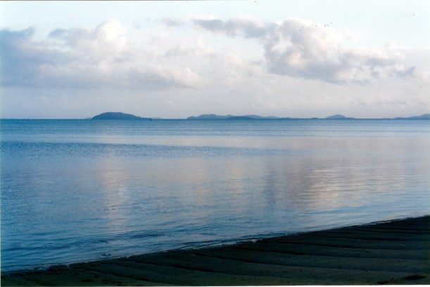
Big barge, small barge, moon and Red Island Point, from our camp

We made an easy pack up, especially considering the length of time we have been here: the longer we stay in one place, the more stuff is strewn around.

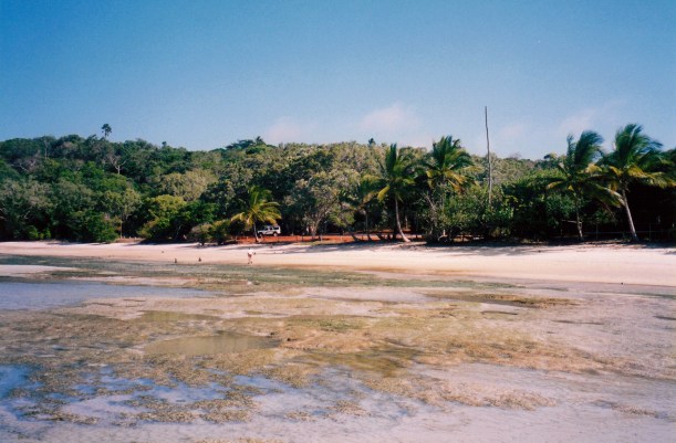
I have loved our time at Seisia – for the magical outlook to the islands. Could never get sick of that.

Drove into Bamaga, aiming to try to get some fruit and vegies. Some fresh stocks from the barge had been unpacked. I also got some reduced “bargains” from old stock – mandarins and capsicums.

We moved to Punsand Bay, on the rough roads. Here, we had to pay $16 a night but there was no power, and no free seventh night. We could only choose our site from within two of the ten bays – tour operators and groups were using all the others. They surely do not encourage the independent traveller! The lady operating the office was a real sour puss.

We chose a site in Bay 9. It has some shade, shelter from the wind, and a tiny view out to sea. It has an ageing amenity block of 2 toilets and one shower. The shower water obviously flows across the floor to combine with the grey sand that is the ground here, to create grey mud. Not the most attractive amenity. The doors and walls are rotting. I guess the climate up here is tough on such structures, and getting repairs done would be very costly.

After we got set up – big tent again – and had lunch, we drove back to the Tip – as we had promised ourselves, last year, we would do on this anniversary.

There is a track goes from Punsand, across to the Tip track, roughly parallel to the coast, so we did not have to go back to the Lockerbie section. It is narrow, winding, and rough. We saw a big snake – python? – on the track and it slowly moved off.

At the Tip, walked out again, as we had before. Took more photos. Managed to climb up onto the cement 44 gallon drum base of the sign – bit of a squeeze – and have a fellow traveller take our anniversary photo up close and personal with the sign.

08-10-1998 02 Cape York tip on wedding ann.jpg

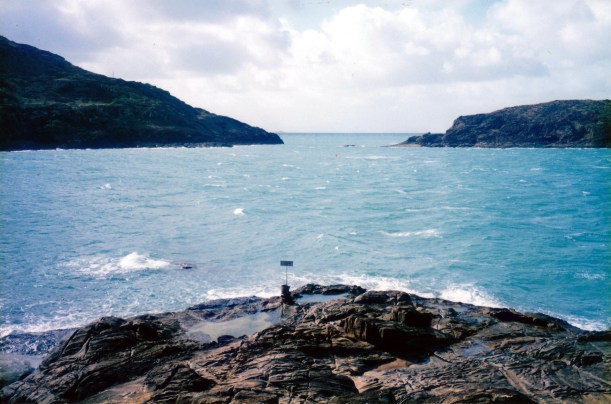
Today, the sea was rougher, but looked more blue, at the Tip

08-10-1998 03 us at tip.jpg

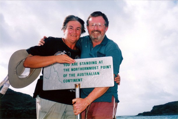
On our wedding anniversary

Gazed once again at the views. Then retraced our route. We encountered the Unimog from Hell coming the other way and had to back up and find a place we could squeeze in beside the track to let him pass. He did not even acknowledge us. Arrogant pig of a man. The vehicle was making heavy going of the track. Then we had to keep stopping on the track, to clear all the tree branches and debris his too-large vehicle had pulled down onto it as he passed. I was uncharitable enough to hope he’d done himself some damage!

Lazed about for the rest of the afternoon. This is a good place to camp, in that it “feels” positive. It does not have the wonderful, direct sea views of Seisia, but has a better atmosphere. It is a bit crowded though. We will stay here for a week, and just enjoy the place. Having gone to the trouble of getting up here, we want to enjoy being here, rather than rush back south again. I doubt we will be back up here again, so really want to make the most of it.

I discovered there is a green tree frog living in the toilet. Must make sure to always check, in and around it, before sitting down! I guess this is another local who does not like the tourist season.

I made John an omelette for tea, with the last of the eggs. I had some salad. Not a great anniversary feast, but maybe we can have a belated meal “out” when we are back in civilization again. We did open our final bottle of Yellowglen bubbly. I am a bit surprised it has survived these roads intact. Well, bottle intact, the taste not quite so much!

At night, with the tide in, can hear the sea clearly, which is nice. Could also hear much noise from a party of young drinkers, in Bay 10. A couple in our bay, but nearer to them complained to them. Eventually, they settled down, but it was pretty late.


Leave a comment

1998 Travels August 7

FRIDAY 7 AUGUST     SEISIA

We took packed lunches and went out for the day, visiting Punsand and Somerset.

It was back to Bamaga, and then up the rough road again. This time, we turned off at Lockerbie and took the track to Punsand Bay.  The track is rough, even worse than the one to Pajinka. One definitely needs a high clearance, sturdy vehicle for that. There are some quite deep sandy patches too.

There is a camping ground at Punsand. We walked around and looked at the campground. It looks very pleasant, with big cleared bays in the bush, that each take several camps, with shade and shelter, and opening onto the beach.

The beach of Punsand Bay is a lovely, long sweeping one, where one can see clear to the Tip, but without the multiplicity of islands that make the outlook from Seisia so superb.

We are tempted to come and stay here. It is clearly much used by tour groups – some of the bays are set aside for these.

We retraced our way back to Lockerbie, then a few kms further on, took the track to the east, and Somerset.

In 1864, the Queensland Government decreed that a settlement should be established beside the busy Torres Strait waters of the northern Cape – partly to show British ownership, partly to assist sailors. There had been a number of deaths of sailors, when shore parties, or those wrecked, had been killed by the very hostile aborigines of the area. John Jardine was appointed the first police magistrate, went there by ship, and with a son, built some of the buildings for the new settlement, on Somerset Hill.

08-07-1998 06 somerset view.jpg

The beach and setting of Somerset. The homestead was on the hill behind Truck.

At the same time, his son Frank was driving a mob of cattle and horses north from Rockhampton to the new settlement, where he established cattle stations and also got involved in pearling and coastal shipping. He married a Samoan princess, Sana. When the administrative centre for the Cape was moved to Thursday Island, in 1877, Frank Jardine bought Somerset. He lived there till his death in 1919 (from leprosy); his descendents remained there until they were evacuated in WW2. The Somerset homestead burned down in the 1960’s, so today there are only a few remnants of the family’s time there. Frank Jardine was reputed to be very cruel and ruthless  towards the aboriginals of the area – but they had also had a history of fierce attacks on sailors and settlers, and reputed cannibalism.

At Somerset, we looked at the ruins of the former homestead, up on the hill, traces of the landing jetty, and the graves of Frank Jardine and Sana at the back of the beach. Also of their grandson, Herbert “Boy” Vidgen. There is a pair of cannons, too, that perhaps were found by Jardine in a wrecked ship.

08-07-1998-02-somerset-site

This once was the entrance to the Somerset grounds. Jardine’s flagpole with flanking cannons. Graves.

Since this family played such a pivotal role in the history of Cape York, I felt it wrong that no real attempt is being made to preserve this historic site. Indeed. people have built campfires amongst the ruins of the house. We do get the impression that the Injinoo will not preserve anything to do with white history in these parts! But why doesn’t a government step in – or would that upset local sensitivities too much? It is our history, too! Meanwhile, Somerset continues to crumble – and it IS an interesting place.

08-07-1998-05-somerset-graves

Graves at the back of the beach at Somerset

Albany Island – a large one – is just across a channel from Somerset. We could see a house and occupied area there, which looks substantial.

08-07-1998-04-fly-point-and-channel-by-albany-island

Channel between Albany Island and the mainland – seen from Fly Point

We drove down to the beach, to the south, and ate our lunch by the sea. Saw some campers in the distance. Found out later that R was one of these – this was the site of the bush camping.

While we were on the Somerset beach, saw one of the coastal ships come charging in – apparently head on to solid land. We got a bit worried there, because we hadn’t at that stage, been up high enough to see Albany Island and the narrow strait between it and the mainland. By the time we did get up to the point, the rear end of the freighter was receding fast from the other end of the channel. It would not be a nice passage to negotiate in bad weather! In fact, in reduced visibility, these waters would be totally treacherous. It is easy to realize why there were so many shipwrecks in earlier times, around here.

Drove to Fly Point – a rocky headland to the south of Somerset. From there, we could clearly see the channel between Albany Island and Somerset. So that explained the ship’s direction to us.

08-07-1998-03-wrecked-boat-fly-point

At Fly Point

After exploring the Somerset area, we headed back towards Lockerbie. Stopped at the Croc Tent to buy icy poles – it was another hot day.

The tent man persuaded us to give a ride back to Seisia to two German female backpackers who were there. They were trying to hitch hike back from the Tip. A tour bus had picked them up – an unusual occurrence – and brought them back to the Croc Tent, for their safety. They did not realize the risks they had taken. The Croc Tent man said that a group of Murris could come along and then they could well have been in trouble! We moved our gear from the back seat so one could sit there and the other had to perch on top of some tarps and shadecloth that we put on the metal floor of the rest of the back seat area. She could – kind of – wear a seatbelt. The girls were grateful – they had already talked to John on the beach at Seisia a couple of times, so we were not total strangers. The Croc Tent man was very happy! But we still paid for the icy poles!

We took the short cut road back to Seisia, from south of Lockerbie, to avoid the corrugations of the Bamaga road. It wound all about and was not fast, but the surface was better.

We drove 111kms today.

The unimog and its family contents was still there. Still noisy and intrusive.

Tea was curried tuna and rice.

As in most prior nights, sat out in front of the tent, watching the sunset, and then the moonlight on the waters of Endeavour Strait.

08-06-1998 07 top islands.jpg

The constantly changing outlook from our Seisia camp