
FRIDAY 13 MAY PUNGALINA
Usual work for John and hours of research at the computer on my part.
John painted a sign on an old drum lid, as he had done in other jobs. O wanted the sign to put up at the point where the coast track crosses the Calvert. He wanted to deter unauthorized people coming onto the property from the Seven Emu Station side, to the west.
The original Gulf Track (Old Queensland Road) – now extremely rough and overgrown – came through from Wollogorang, to the east, crossed the river at this point, then continued on through to Seven Emu. This latter section, though very rough, was still driveable, and there had been a few unwelcome visitors turn up that way. These days, it was hard to find evidence that this was, in the 1880’s, a major stock route, over which many thousands of cattle were driven from the eastern states to the NT and the Kimberley of WA.
We’d had some discussion with O about the route of the explorer Leichhardt’s expedition through this way. John was particularly interested given he is related to John Roper who was part of that exploring party. It seemed that O’s crossing point of the Calvert was at one time thought to be where Leichhardt crossed, (but eventually this had been shown to have been at a point a little further north.) But the old stock route had followed some of the explorer’s line, but crossing at this easier, more shallow and less tidal point.
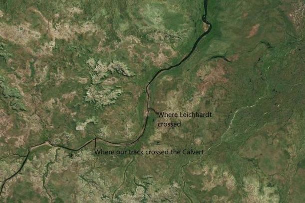
The Calvert River was named by Leichhardt for a member of the expedition.
O had set out at dawn with the slasher. He would camp out again tonight. Making this track drivable again was a big job and one that usually needed repeating after every wet season.
We did the mail plane routine.
The disc of the Curreys catalogue was in the mail. That would really help me.
We brought the Troopy down to our camp and transferred the gear we would need for an overnight camp into it: small tent, lilo, bedding, food.

Computer games!
