This Adventurous Age

Adventures travelling and working around Australia.


Leave a comment

1999 Travels June 16

WEDNESDAY 16 JUNE   KINGS CANYON TO ALICE SPRINGS   342kms

It was another beautiful sunny day with a cloudless blue sky.

We got away quite well, at 9.30am.

The Mereenie Loop Road was varied going, but always interesting scenery. There were some corrugated sections, some areas of road works. In places, surface runoff in storms has cut into the road and made channels and sections where only one vehicle can squeeze through. This damage does not look all that recent.

06-16-1999 04 meereenie tk.jpg

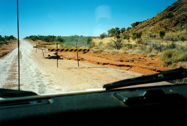
Gives a new meaning to “beware – soft edges”! Mereenie Loop Road


We stopped at a lookout point back over the George Gill Range.

Encountered a couple of different and amusing road “signs”, each end of quite a sharp bend: Lift um foot………..Puttum back down! Painted on old drums. Guess some of the locals had come to grief on that corner, over time.

06-16-1999 02 meereenie loop sign

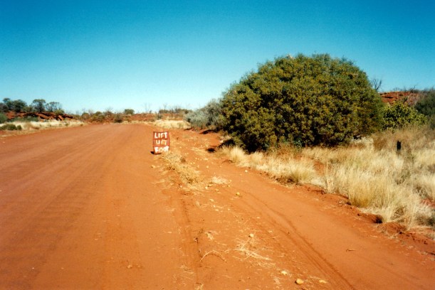
Means there is a sharp corner coming up – slow down!

06-16-1999 03 meereenie loop more sign

Beyond the corner. Can speed up. Some punishing corrugations though.

We saw a drilling/bore crew setting up, not far from the road, and from that assumed that the Mereenie oil/gas field is producing. There were also pipeline markers as we got further along.

There was not much traffic on this road. We just took it steadily and carefully, but were passed by a Disco, towing a camper trailer, at speed. He threw up stones over our front.

Came upon a broken down rig – vehicle and trailer – with a couple and two young children. A bracket under the trailer had broken, affecting the axle and wheel. He was not in the NRMA – not that there is any easy way of summoning roadside assistance out here! John helped the guy chain the axle into place, using some chain we had, and we followed them as they drove slowly towards Hermannsburg.

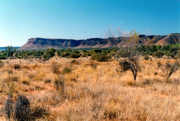
Some time after the road swung back to the east, we could see, coming closer, the hills that mark the Gosse Bluff. This is an old impact crater – probably from a comet that hit the earth a very long time ago, and exploded. Back then, the hills that form the rim of the resulting crater, were very much higher, but erosion over time has worn them well down. But the feature still stands out, very strongly.

06-16-1999 05 gosse bluff

Gosse Bluff from the Mereenie Loop Road

The road deteriorated markedly after the junction with the Gosse Bluff road.

Just before Hermannsburg, we came around a bend – and there was the Disco and camper trailer, all flipped over with wheels in the air and the roof torn off the camper. Two men were getting things out of the interiors. One was the driver, the other was presumably someone from Hermannsburg. The accident had obviously happened a while ago, because it had been a while since he had passed us, and we’d had the other stop since then.

We stopped to see if help was needed. The driver said he was a doctor and his wife had been taken into see a doctor at Hermannsburg, with sore ribs. He seemed remarkably unshocked. It all looked a hell of a mess. He said that he had gotten into the soft sand on the shoulder of the road, lost control, snaked all over the road, hit the bank and flipped, finishing up facing back the way he’d come. He said he’d only been doing about 5kms an hour at the time – no way! Given the speed at which he’d passed us – and, likewise the young couple we were following, who said he’d been doing at least 80kmh – we found that extremely hard to believe. He also said it was a new rig, and he’d left Adelaide the day before. All the hallmarks of a traveller in far too much of a hurry and driving far too fast for these conditions.

06-16-1999 06 oops

Oops! How quickly it can happen

The driver said they were going to try to pull the vehicle back over onto its wheels – like he thought it might still be driveable!

We passed police coming out of Hermannsburg, but no sign of any tow or help equipment.

In at the Hermannsburg settlement, the young couple found they would be able to get welding done to fix their trailer, so we left them there and continued on our way to Alice Springs. Going in along the Larapinta Drive – which became a sealed road about 40kms after Hermannsburg – was really pretty, with the West MacDonnell Ranges looming.

06-16-1999 larapinta rd.jpg

Better road and West MacDonnell Ranges

After an eventful trip, we reached there at 4pm. Booked into the MacDonnell Ranges Caravan Park, at a cost of $113 a week, after Big 4 discount, for three weeks. John thinks we will need that long here, to explore thoroughly – and play bowls. I’d have been more inclined to book in for two weeks. We have been here before – briefly – and on that visit explored out to the east, as far as Trephina Gorge.

We were given a nice big site, with shade trees, looking out towards the ranges to the east. This caravan park is south of the town, through the Heavitree Gap that cuts through the range. We stayed here for a couple of nights on our LSL trip and liked its quiet and security, being out of the town, plus it is modern and very clean.

Just on dark, we drove into town, only a couple of kms away, to buy wine – which we have been out of for a while now – and to get a pizza for tea. Took this back to the van to eat, and it was very nice too.

John’s “good” hip is very sore today, after yesterday’s walk, and he took some Surgam today, to try to ease it.

06-16-1999 kc to alice.JPG


Leave a comment

1999 Travels June 14

MONDAY 14 JUNE     KINGS CANYON

Today was another beautiful, sunny day.

06-12-1999 camp kings canyon.jpg

Our scenic camp site at Kings Canyon Resort

John’s hip was rather sore after the uneven ground walking of the past couple of days.

We did not want to just spend the day around the camp ground, so took a packed lunch and drove to the Kings Canyon car park. It was our intention to walk the King Creek valley track again, much more slowly than on our first afternoon here, looking at plants and birds and just generally enjoying the place.

06-14-1999 01 holly grevillea.jpg

Holly Grevillea

We sat in the creek bed, not far from the end of the track, away from the track and the crowds, and ate lunch. John had a nap after lunch, while I sat and spotted birds. Didn’t manage to identify any new ones but saw a number of ones first seen in other places.

06-14-1999 03 Kings Canyon post lunch nap.jpg

John napping in the creek bed

Then we spent some more time by the track, unfortunately often being annoyed by the hordes from the touring coaches – some of them make such silly, dumb comments. I am afraid that I could not bear to travel in such groups.

John made a rather ambiguous statement to me, about some birds being more attractive than others. He was taken to task by a lady who overheard him! Possibly it served him right! But we were wearing binoculars and carrying a bird identification book at the time.

Then he got into a bit more bother, trying to be friendly and chat to another lady walking on the track, about the fact that she was limping. I think he thought that here might be a fellow hip replacement case. But she had an artificial leg. Whoops. After that, he stopped trying to be sociable.

06-14-1999 02 canyon rim from valley

The Canyon rim from the end of the Kings Creek walk track

Drove back to the Resort and, at Reception, obtained our permit to drive the Mereenie Loop Road. This unsealed road loops around the western end of the ranges here, then turns east, eventually leading, via Hermannsberg, to Alice Springs. We’d debated whether to go that way, or take the Ernest Giles Road east to the Stuart Highway. They are a similar distance – about 330kms. There is only 99kms of unsealed road on the Ernest Giles Road, as opposed to about 230 on the Loop Road – but the latter seemed potentially much more scenic. It is designated as a 4WD road.

Because the Mereenie Loop Road transits aboriginal lands, the permit is needed to travel it. The rules forbid camping, or stopping anywhere along the aboriginal land section, apart from at a couple of specified lookout/rest points. It cost $2 and we received an accompanying information booklet.

The staff people at Reception said they’d had to deal with several vehicle emergencies, recently, especially on the Ernest Giles Road – rollovers and the like. They commented that so many travellers do not seem to know how to drive safely on unsealed roads, and travel too fast.

The power had been off during the day. It is generated here. There were signs up around the place saying no EFTPOS, no TV, no radio. We think the satellite dish that brings these services must be not working. There were no telephones, either.

Tea was veggie soup that I made in the late afternoon, lamb backstrap – marinated in oil, lemon juice, garlic and dried oregano, then pan fried; potato and peas.

Just after we finished washing up from dinner, the power went out again. We were alright, because we have 12v lights that work from the battery, but plenty of other campers were scrambling about in the dark. It came back on after about 90 minutes.


Leave a comment

1999 Travels June 10

THURSDAY 10 JUNE     KINGS CANYON

We got up about 9am. We certainly seem to be sleeping in later these days, possibly because it seems to get light later. It is a big contrast to this time last year, in Qld, when I was waking so early.

After breakfast, I did three loads of washing, including the sheets. At $2 a load, it was 40cents each time cheaper than at Yulara. It was a sunny day with a strong breeze – good for drying.

It turned into a puddling about type of day.

John did some work on the TV aerial and checked the Truck batteries. I washed the van floor. We just relaxed in the sunshine and relative quiet of the camp ground.

Later in the afternoon we drove out to the west, on the unsealed Mereenie Loop Road, for about 25kms, to a little way beyond the National Park boundary. The country was interesting, with the dissected ranges in the distance. We spotted a brown falcon – a new bird for our records.

06-10-1999 george grill range.jpg

The George Gill Range, seen from Mereenie Loop Road

We were passed by a couple of carloads of aborigines, heading east towards the Resort – wondered if this was due to it being pension pay day? They seem to drive very fast.

We went back to the Resort and the shop. Newspapers here only come in on Wednesday and Sunday. Supplies at the shop are expensive. I bought a roll of film, which at $7.50 for 24 exposures, is much more than I am used to paying. Also bought postcards and magnets – one for me and one for P, who is collecting them.

Tea was tinned mushroom soup – which I managed to boil over onto the stove! Then chicken breasts done Greek style, potato and zucchini, followed by the ever reliable yoghurt.

06-09-1999 desert dusk light Kings Canyon.jpg

Dusk light on the Range from the campground – the gradation from pink through purple to blue is typical of Central Australian dusk

After tea, I wrote a letter to a friend. John tried to phone S, from the camp ground phone box, but couldn’t get through.

There was a large Britz hire camper parked behind us today, with Japanese occupants. Apparently, they were filming a feature or advertisement on Japanese camping in Australia. They had pre-cooked food, but filmed to make it appear they were cooking it! They set up the camp ground provided table for dining out – after moving it from near us – but soon abandoned that venture as the late afternoon chill set in. They were very noisy. They departed with their camper about 11pm. John said they came back later, after I was asleep and they were quite noisy then, too.

It was a cold night. I went to bed about 11pm. John played his computer game till 4 am.