This Adventurous Age

Adventures travelling and working around Australia.


Leave a comment

1998 Travels May 12

TUESDAY 12 MAY     CATHEDRAL BEACH TO TORQUAY

An early start – we have lots to do today before we go back to the mainland. Why, oh why, did we not plan for a longer stay? I guess it was hard to know beforehand how much there was to do here, and we may have been a bit misled by the existence of day tours. Now we are here, we know we could easily have filled in the best part of two weeks –  instead of five days.

Packed everything up and sallied forth onto the eastern beach again, and northwards.

We went past more coloured cliff formations, the Cathedrals, where we walked and took photos. These were somewhat similar to Rainbow Valley, yesterday.

05-12-1998 08 Cathedrals Fraser Island.jpg

The Cathedrals

05-12-1998 07 creek near cathedrals.jpg

A creek behind the beach at The Cathedrals

On to Indian Head, which is a rocky headland about two thirds of the way up the island. It is one of only three rocky outcrops on this sand island. We parked Truck on the beach below it and walked up to the top of Indian Head. From there, we saw good views  – to the north was Middle Rocks and Waddy Point; to the south we looked along the stretch of the 75 Mile Beach and across a big sand blow too.

05-12-1998 01 waddy point and middle rocks from indian head.jpg

Middle Rocks and Waddy Point, seen from Indian Head

05-12-1998-04-truck-below-indian-head

East Beach from Indian Head. Truck is the left-most one of the vehicles parked by the beach exit

Back down to Truck. John put it in low range and we managed the very soft, partly corded, bypass track off the beach to the back of Indian Head, past three bogged vehicles. Truck battled, but made it. John then had some difficulty with the gears and getting out of low range – there is something called transmission wind up mentioned in the manual but we are not sure what that is. Eventually, there was a loud clunking noise and all seemed ok. It was a bit unnerving, though.

We drove as far north as Middle Rocks and walked to the Champagne Pools – rock pools filled by the sea at high tide, then went on to Waddy Point.

05-12-1998 06 Champagne Pools Middle Rocks.jpg

The Champagne Pools

05-12-1998-05-indian-head-from-middle-rocks

Looking back to Indian Head from Middle Rocks

We did not have time to explore further in this part of the island. Turned south again – it was easier going back down the Indian Head bypass! Found a fishing spot by a likely gutter not far from the Pinnacles. We both fished. I kept losing bait and caught two very small dart that were returned from whence they came.

We fished until nearly 2pm, which was as late as we were game to leave it, before our trip back across the island to the barge at Moon Point. This meant we were taking one of the lesser used tracks, the Bullock Track. It was very sandy for the first few kms, and very bendy. We met three oncoming vehicles – tricky! The track improved further inland, but was still slow going. It took us about an hour and a half to cross the island – this was its widest point, too. Parts of the track were through swampy heathland – a bit like the Grampians. John really enjoyed this drive.

The Moon Point end was not signposted – in fact, the whole track was poorly signed. The track just entered the beach, with little warning. We wondered if we were lost. The sand on this beach seemed deep, with few vehicle tracks on it. We asked some people who emerged onto the beach from a little further along  and they confirmed it was the barge landing point. Then, when we looked closely, could see the ridge of sand pushed up by the barge front on the morning run. A little further along from where we’d emerged onto the beach, there was another access point, and that had a sign.

05-12-1998 11 beach at Moon Point.jpg

The deserted-seeming beach at Moon Point

05-12-1998 12 barge landing area moon point.jpg

Sand pushed up by the morning barge at Moon Point landing

Then, could even see the barge, coming in the far distance.

The sandflies here were ferocious – there are a lot of mangroves around this area. It was amusing to watch the antics of a busload of tourists who arrived after us and danced around applying repellent. At first, they probably wondered why we were – by then – in long trousers and long sleeved tops, which we had changed into quickly, after the first assault.

There were two dolphins playing offshore and a big turtle sticking its head up out of the water, periodically.

05-12-1998 13 barge arriving Moon Point Fraser Island.jpg

The barge coming in to Moon Point

The barge came in and ran its driving ramp up the beach – and we loaded. Three cars only and the people from the bus. The bus itself was parked up in the bushes to await tomorrow morning’s arrivals. Again, had to back onto the barge. Then, we just waited, wondering why. Another bus load arrived and loaded. The bus tour companies are in radio contact with the barges.

05-12-1998 15 truck loading onto barge.jpg

Loading Truck onto the barge at Moon Point

It was a beautiful trip back, as the sun was setting. It took an hour this time, as Moon Point is further away. We landed at Hervey Bay Marina, so only had to drive 4 kms back to the caravan park.

05-12-1998 16 leaving Fraser Island at sunset.jpg

Looking back as we left Fraser Island at sunset

Van was still there, and all was well. We offloaded only the essentials – it was quite dark by now. Moved what we needed to, for access to the van, back to Truck, then John went off and got fish and chips for our tea.

After a very long and full-on day, an early night was definitely in order. I really appreciated the very comfortable van mattress, after the lilo!

We are so pleased that we waited out the weather, school holiday crowds,  and made the effort to visit Fraser Island. It will take some very special experiences to out-do this one. It is why we are travelling as we are.

Today, we drove 107kms on Fraser Island – very much our greatest day’s travel there.

05-12-1998 Fraser Island.JPG

Our Fraser Island travels


Leave a comment

1998 Travels May 11

MONDAY 11 MAY   LAKE MCKENZIE TO CATHEDRAL BEACH  

Overnight rain meant that we packed up a damp tent that we will have to dry out later.

Some of the latest crop of backpackers were quite rowdy last night, and are very seedy this morning. I was walking up the track towards the toilets, behind a couple of the lads, and heard one ask the other: “Do you remember the name of that chick I screwed last night?”……..an interesting insight into backpacker antics! I wondered if this was a peculiarly Fraser thing, or if maybe it was like that when my step-daughter and her friend went off through India and South East Asia. I wasn’t sure I should share this with John!

After pack up, took the quickest way to the east beach at Eurong, where we shared a portion  of the beach with a plane. This is not uncommon, here.

05-11-1998 01 at East Beach Eurong.jpg

Sharing the east coast beach “highway”

Then drove north along the beach, stopping at various tourist sights.

At Rainbow Valley, we walked up amongst some of the spectacular coloured sand cliffs that occur in these parts, where clays have stained the sandstone and also hardened the sands somewhat against erosion. The cliff walls really were multi-coloured, from greeny through to ginger, and with varied erosion patterns. Unfortunately, it was a very hard scene to photograph and do justice to, due to the narrowness of the little gorge.

05-11-1998-02-rainbow-valley-fraser-island

Rainbow Valley

Further along, we came to an area called The Springs, near one of the sand blows, and spent some time wandering amongst dry channels and hollows in the soft semi-rock.

05-11-1998 04 The Springs Fraser Island.jpg

John exploring the formations at The Springs

Then we came to Eli Creek – a major attraction of the island. This is a fast-flowing, clear water creek, with a board walk along side. The creek discharges some 80 million litres of water a day, into the sea! There are huge ground water reserves under Fraser Island, that feed the occasional spring fed creek. Eli is a stop on the day tour circuit, so it was relatively crowded. We had our lunch there, watching fish and a big eel swim in the creek. Obviously a “to do” thing here is to float/body surf down the creek, from the board walk’s end to the beach. We were not tempted – there were a few too many younger bodies to compete with for space in the water. I managed to take a photo of Eli Creek, but it took quite a lot of patience to capture it without bodies

05-11-1998 05 down Eli ck.jpg

The incredibly beautiful Eli Creek

Further north again, we stopped at the wreck of the “Maheno” – a former liner and WW1 hospital ship. In 1935, it was being towed to Japan for scrap when cyclonic conditions blew it onshore here. Then it was used for bombing practice in WW2. It is now an interesting, rusted out, photogenic skeleton partly buried in the sands. We wandered around – and in – it, taking photos. There was another pair of dingoes at the back of the beach, here. A Ranger drove through and stopped near them and they went away. Seems they associate Rangers with being unwelcome!

05-11-1998 06 Maheno wreck.jpg

The wreck of the Maheno

05-11-1998 09 dingoes near Maheno wreck.jpg

Two dingoes on the beach at the Maheno wreck area

Just north of the “Maheno” is the Pinnacles formation – more coloured sand cliffs, this time fronting onto the beach. These appear on many of the Fraser Island postcards – as does the ship wreck. We walked and took photos and admired the structures. I found the erosion features of the Pinnacles more significant than the coloured sand layers. I remembered that, many years ago, when my children were young and spending a holiday with their father, they did a day trip here and brought me home a souvenir bottle of coloured sands from these parts, which I still have. I doubt that they were old enough to appreciate the beauty and diversity of the island, though.

05-11-1998 10 the Pinnacles.jpg

The coloured sands and erosion features of the Pinnacles

After this, we reached Cathedral Beach, with its private campground, some 29kms along the beach from Eurong. It took a long time to do that distance – there is a lot packed in there to see, along the way. The camp cost us $20 for an unpowered site. I was not impressed! We were the only tent campers there – given the cost and the nearby cheap camps in the dunes behind the east beach, I am not surprised. Still, it is a nice setting, there are lots of birds, and the location suits our plans for tomorrow.

We put up the small dome tent that was part of my farewell present from my staff. First time we have used this. We wanted it for overnight stays like this. Our lilo just fits in the dome tent, with a little crawl space on each side. As the night is supposed to be fine, and not too cold, this open air camp will suffice. Very bare ground all round.

05-11-1998 12 camp at Cathedral beach.jpg

Our basic camp at Cathedral Beach

After our quick camp set up, John went off down to the beach to fish. I had a very enjoyable shower – the first for three days! I could not be bothered, where we have been, queuing up with the backpackers for the shower there – and putting up with the mess they created in it. But I enjoyed this one – and it was warm!

John did not return until after dark – fish-less.

Tea was tinned tuna, in the absence of fresh fish –  and some salad.

There was no dingo chorus tonight.


Leave a comment

1998 Travels May 10

SUNDAY 10 MAY     LAKE MCKENZIE

We were up early again, due to bird and camp ground noises.

Drove back to Central Station. Parked there and wandered around, without the little crowd from the barge that had been there when we came through on Friday. Obviously, it is most people’s first stop, though not all that popular for camping.

05-10-1998 04 Central Station.jpg

Central Station, in the rainforest

We walked the Wanggoolba Creek Rainforest Walk – a boardwalk of about a km, through the rainforest. This is unique – rainforest growing on sand. It is the only such place in the world.

The creek water is so clear that it looks dry – one just “sees” the sandy base. Although the creek flows quickly, it is silent, which adds to the illusion. The walk was like being in a green church – very cathedral like. I loved the variety of ferns that grew all over the place.

05-10-1998 05 Wangoolba Creek clear water.jpg

The crystal clear water of Wanggoolba Creek; it is over 40cms deep here

From here, we headed south on yet more inland tracks, to visit three more significant  freshwater lakes in this part of the island. Each has a different character, each is very photogenic.

Like Lake McKenzie, which it closely resembles, Lake Birrabeen is a perched lake. It has clear, aqua coloured water and white sandy beaches. We explored around there for a little while.

05-10-1998 09 Lake Birrabeen beach.jpg

Interesting patterns on the shore at Lake Birrabeen

05-10-1998 08 Lake Birrabeen Fraser Is.jpg

Lake Birrabeen – very like Lake McKenzie

Then on to Lake Benaroon, similar to the first one. As we saw no other travellers at any of these beautiful lakes it seems that everyone is intent on exploring the east beach.

05-10-1998 10 Lake Benaroon.jpg

Lake Benaroon

We had our picnic lunch at the last of the three – Lake Boomajin. This is the largest perched lake in the world. Its water had a browny tinge, because some little creeks flow into it, bringing tannins derived from paperbarks. There is a good picnic and camp ground at Lake Boomajin – but no-one there. Maybe it is a little too far south for most visitors? But, in reality, it is only about 20kms from Central Station. We had lovely views from the picnic area, over the lake, which is where the film “Eliza Fraser” was filmed.

05-10-1998 12 Lake Boomajin beach.jpg

The sandy foreshore of Lake Boomajin

While we were eating lunch, a pair of dingoes silently appeared, came right up to our table and started nosing around for scraps – of which there weren’t any. These were the most bold ones that we encountered on the island, and the only time we felt at all threatened. At one stage, I was sitting on the table with my feet on the seat and a dingo sniffing at my toes! John was feeling particularly vulnerable, since he really can’t run yet. He went to walk down to the lake and one followed him down the track. John turned and faced it and it sat down and watched him – standoff – but eventually it decided to stroll off.

05-10-1998 11 Lake Boomajin picnic area.jpg

John is keeping a wary eye on the dingo at Lake Boomajin picnic area

From the lakes, we continued on the same track, through some interesting swampy country that was a change from the forests, to Dilli Village, a small old resort cluster of buildings on the east beach. Then we headed north along the beach, for the ten kms back to Eurong. Stopped for an hour for John to try some fishing. I explored a nearby sizeable stream – Govi Creek – that flowed across the beach. It had photogenic little cliffs in the beach sand, through which its fast flowing waters had made a curving channel.

I found a fair sized tortoise stranded in the fast current, and moved it back to the lagoon area, behind the beach, where it better belonged. Govi Creek is certainly one that could bring unwary drivers undone – the place to cross it is right down by the surf, where the channel is not incised into the sand.

05-10-1998 16 Govi ck.jpg

Govi Creek flowing over the beach on the east coast. A hazard for drivers.

On to Eurong, and back to camp. On the track near Eurong, there was one of the ubiquitous backpacker Troopys with a flat tyre. Several girls were reclining in the shade (today was quite hot), while the guys dealt with the wheel. They seemed to be having a hard time, too. It occurred to me that women’s lib has its selective limits amongst the backpacker girls.

There were some storm clouds building up, but it was warm, so we went for a swim in Lake McKenzie. Our first swim for the whole trip, to date! This was absolute magic – late afternoon, churning grey clouds, the lake bright aqua at the edge and then deep inky blue about five metres from the shore, where it gets very quickly deep. It was most unusual to swim in – dark, but iridescent. There were tortoises swimming not far from us, too. It was a very pleasant swim.

05-10-1998 01 lake mckenzie.jpg

Lake McKenzie – where we went swimming. Aqua, then inky blue water, and white silica sand

It started to rain, so we walked back up the track to camp.

I made fettuccine with a bottled tomato sauce for tea.

The Coleman lamp started flaming and flaring – not sure why. It may have some sand grains somewhere they shouldn’t be. We turned it off, but will have to fix it later, before we go bush camping again. It is too good to be without.

We drove 65 kms today.


Leave a comment

1998 Travels May 9

SATURDAY 9 MAY     LAKE MCKENZIE

We were woken early by the loud bird chorus – mostly crows redefining their territory with the dawn. After waiting in a bit of a queue for the amenities, walked down to the lake and saw mist rising off it – quite beautiful. I attempted some bird spotting, but they were all very busy doing their morning things, and did not keep still enough for me to have much success.

Had our breakfast, then packed things we thought might attract dingoes, back into Truck.

We drove back to the western side of the island, on a road that goes from near our lake, to McKenzie Jetty, which is north of where we landed yesterday. Timber used to be loaded and shipped from here, but now the jetty is a set of derelict, but photogenic, ruins. This is an island site that a lot of tourists, apparently, do not visit.

There was also an old boiler and tractor on the beach, part buried in sand. Oysters were growing in all the crevices of the tractor, but its rubber tyres were still in place – a strange sight.

05-09-1998 06 relics at jetty ruins.jpg

McKenzies Jetty and old tractor

It was a lovely little beach, with the mainland clearly in view in the distance. In places, little mangroves were trying to establish themselves in the sand.

We walked about a km along to where the old settlement used to be, in the days when the jetty was used.

05-09-1998 04 old boiler on McKenzie jetty beach.jpg

The beach near McKenzies Jetty, old boiler, little mangroves

After that walk, drove back, on inland tracks, to Kingfisher Bay, the newest resort, also on the west coast. This resort complex is designed to blend into the environment and the developers seem to have done a good job of making it unobtrusive, yet still quite upmarket. It has its own pier and barge landing facility. There were several yachts moored in the bay – owners taking a break at the resort?

We walked out along the pier and from its end could look back at the Resort, tucked away in the bush.

05-09-1998 07 Kingfisher Bay resort from its jetty.jpg

Kingfisher Bay Resort is in there! Seen from its pier

I was surprised to be able to buy the Weekend Australian paper at the jetty kiosk there, for only 50cents extra to its normal charge. At the resort store, we were able to buy some meths for the lamp, and treated ourselves to a coke and cheezels. Junk food indulgences are creeping in!

From Kingfisher Bay, we churned our way across the island, on another of the inland “roads”, to Lake Wabby. This lake has been formed by a big sand blow dune that has blocked a creek. Basically, over many millions of years, the entire Fraser Island has been formed by such sand blow dunes, moving sand from where it has been deposited on the east side, westwards. Through time, fresh dunes formed over older ones, so it is a really complex sand island.

Lake Wabby is the deepest lake on the island. It is a deep green colour, framed by the yellow sand of the encroaching dune. We walked about a km to a lookout over the lake, where we ate lunch and watched people swimming. We decided against going swimming there ourselves, feeling that the effort to walk to the swimming section would be too great, and we would get awfully sandy.

05-09-1998 10 Lake Wabby Fraser Island.jpg

Lake Wabby and the sand blow that formed it. There are several people on the sand by the water – to give an idea of its scale.

Back at the car park, there were big goannas foraging around the picnic tables. One looked as if it must have had a huge lunch – it was draped over a big log, seemingly too replete to move.

05-09-1998 08 big goanna fraser island.jpg

Too comfortable to move!

During the trip across the island, earlier, we had driven through tall, true rainforest; and medium forest with eucalypts and banksias dominant in different sections. The diversity of this island is remarkable.

05-09-1998 09 scribbly gum.jpg

Detail on a scribbly gum. The markings are natural, hence the name

From Lake Wabby, we continued east, and drove onto the famed east beach, for the first time, over a boarded section intended to stop bogging.

The views along the beach were wonderful.

05-10-1998 14 east coast highway near Govi Ck.jpg

The east coast beach, showing some of the driving conditions

It was about 3.30pm by now and we were conscious of the early sunsets in this part of the world, so turned south and drove to the Eurong settlement, some 6kms along the beach. At Eurong, found there was an hotel, various sorts of accommodation (no camping) and quite a well stocked general store. I was able to buy some mantles for the lamp, a battery for the big torch, and some postcards. There is no shortage of great views on postcards here!

Then it was onto the main inland track back to Central Station and thence back to camp. The driving on this section was reasonable, mostly one way, because this is the main route across the island. Our first experience of east beach driving had been reassuring, too. The sand was firm, and because low tide had been at 1pm, there was still plenty of firm sand for driving and passing on. Key exit places were signposted. To date, the travel on Fraser Island has not been as horrendous as some material I had read, suggested.

Even the Troopys full of backpackers did not seem to pose a hazard during our driving time there – maybe the huge deposit they have to pay makes them more sensible? However, we did pass several with flat tyres. They carry so many people and with tyres partly deflated for sand driving, seem to be prone to flats from driving over tree roots or staking. John did not deflate our tyres by very much and Truck did fine, only faltering the once, at the Indian Head bypass.

It was almost dark by the time we got back to camp. We drove 65kms today.

Did a quick walk down to the lake to see what mood it was in. Purple and mysterious.

05-08-1998-06-lake-mckenzie

Lake McKenzie in mysterious mode

The camp ground was full – still mostly back packers. We feel outnumbered!

I made fish cakes for tea. Main ingredients potato and a large tin of tuna, and thus well suited to my limited cooking facilities here.

We lit the Coleman lamp for the first time. It gives a brilliant light, excellent for reading by, which the old gas lamp is not. I wrote some post cards, listened to the dingo chorus, and turned in.


Leave a comment

1998 Travels May 8

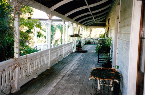
FRIDAY 8 MAY   TORQUAY TO LAKE MCKENZIE

The alarm sounded at 7am.

There was last-minute packing – of things that would not fit in the van until we had moved out! That included the folded up awning, and the bikes and rack. I have a pang or two about leaving the van like this – we haven’t done so before. Hope all will be well.

We had to drive about 23 kms to River Heads and be there by 10am for the 10.15 barge. The departure point was paved, with big car parks, a toilet block, and well signposted. There were a lot of young back packer types waiting for the barge – some in hired 4WD’s, some with commercial tour companies. About fifty of them. We wondered if we are going to end up spending days in the midst of backpacker parties, having heard they can sometimes be somewhat out of control on the island! There was certainly a real sense of anticipation about the place.

On the barge, we Australians are severely outnumbered by Germans, Brits and Yanks.

05-08-1998 01 Fraser Island barge coming into River Heads.jpg

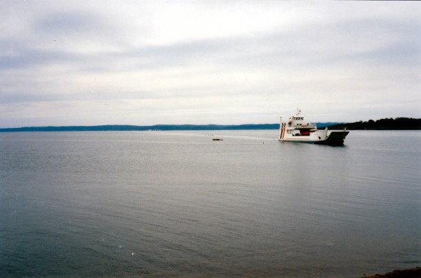
Our barge approaching River Heads to load us for the trip to Fraser Island

John had to back Truck onto the barge – no worries. We had to pay for all costs and permits on board the barge – $65 for the return barge ticket, $30 for the permit to drive on the island, $21 for a camping permit for three nights in National Parks campgrounds. So this is not a cheap excursion! And we had to pay in cash, despite the assurances of the caravan park lady that Visa would be ok! That did not leave us with much cash, though, hopefully, we will not need to spend much more.

So saying, John promptly treated himself to a pie on the barge – his first for quite some time. I bought a Coke – long time since I’ve had one of those.

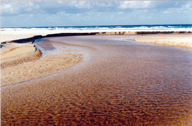
The trip across the Great Sandy Strait took half an hour and at the Wanggoolba Creek end, we drove off frontwards, onto a sort of boarded and asphalted pathway up the beach sand, and on to a sandy “road”. There were two dingoes sitting and watching us come off the barge – the welcoming committee? Certainly, some local atmosphere right from the start.

05-08-1998 02 approaching Wongoolba barge landing.jpg

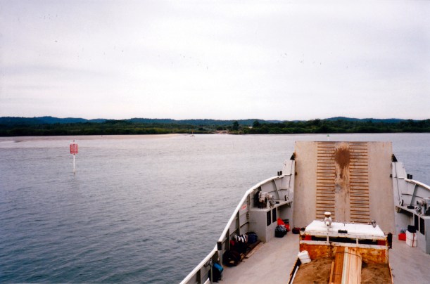
Approaching the Wanggoolba Creek Landing. A truck with building supplies will be first off the barge.

We had to engage 4WD before driving off the barge – those are the rules. Only 4WD vehicles are allowed on the island, as it is a sand island.

I will comment here on our driving experiences, overall, on the island. One travels on the few inland “roads” that cross the island from east to west and, in a few places, join features of importance down the spine of the island. Or else one drives on the beach on the eastern side. The east coast is where the several small, older resort settlements are, and some of the main tourist attractions, though there is a newer resort – Kingfisher – on the western side. The east coast beach is certainly the main thoroughfare of the island. Apart from the usual vehicles and 4WD tourist buses that we saw, there was other traffic too, obviously doing commercial business like taking supplies to the settlements, a big rubbish dumpster truck – and a plane that used it as a runway!

The inland roads are very sandy with varying degrees of being churned up, and depths. One has to watch for big tree roots as well as deep sand patches and former bog holes. There are a couple of one way sections on the major routes, but for the rest, the tracks are single lane, so one also has to watch for oncoming vehicles – and many of the tracks are very bendy. The rule is that the smaller vehicle should back up until it can pull over to let the bigger one through. When you are equal size, it becomes a game of bluff, though we found that most drivers would let the one going uphill – who needed to maintain traction in the softer stuff – have right of way if there was a possible pull over point. We hear that there are many head-on bingles on the island, though we took it carefully and with much concentration, and had no close shaves.

05-09-1998 02 inland rd Fraser Is.jpg

A typical inland road on Fraser Island – this is the main road near Central Station

There is an official speed limit of 35kmh on the inland tracks, which seems impossibly high for the conditions we found. On the east beach, the speed limit is 80kmh! The sand there is mostly firm, although closer to high tide one must drive on softer sand, which can be a hazard if hit at speed coming off the firmer stuff.

The biggest hazard on the beach route is the many creeks that cross the sand. They can build up little sand cliffs and some have quite deep channels that you can drop into, if not careful. Apparently these cause many roll overs! It is very hard to tell, coming up to a creek, what the crossing will be like. In theory, one should walk each one first, but there are just too many. There is no real logic, either – the biggest creeks are not necessarily the ones with the deepest channels. We slowed down at each, followed the tyre tracks of those who had gone before, and hoped! We did not have any bad creek hits.

In places, there are rocky outcrops across the beach and one must deviate on inland bypasses. Where these leave and enter the beach, the sand can be very soft and churned up. The one at Indian Head gave us problems and nearly bogged us – we were thankful for the diff lock on Truck. We churned past three bogged vehicles there.

From the Wanggoolba Creek barge landing, we chugged the 9kms to Central Station, which is as its name suggest, in the middle of the island, behind a big 4WD 6-wheeled truck that was carrying building supplies from the mainland, to Eurong, on the east coast.

Central Station had information boards, a Ranger Station and a campground. It was a fairly open area, amongst tall trees. It was the site of the main forestry camp from the days when Fraser Island timber was exploited. There was logging here from the 1860’s until 1991.

05-08-1998 03 arrival Fraser Is.jpg

One of the Information Boards at Central Station

We stopped and read the information boards and camping bulletins – which warned about dingoes, and also fireweed, a stinging organism in the sea currently causing allergy problems for people at the east coast beaches. Well – I wasn’t intending to swim in the sea, anyway.

We drove on, at a slightly better pace this time, another 9kms to Lake McKenzie campground, hoping to find a place to camp in this most popular area, rather than have to return to Central Station.

There were several places empty in this rather typical National Parks camp area – about 20 sites defined in the bush by treated pine railings, some smaller, some larger. We found one where we could put up the big tent and still have room to park Truck beside it, off the access track. It does seem that most of the campers here are in groups and so are gathered where there are sites close together, so we got lucky with a reasonable one that was more on its own.

05-09-1998 01 camp lake Mc Kenzie.jpg

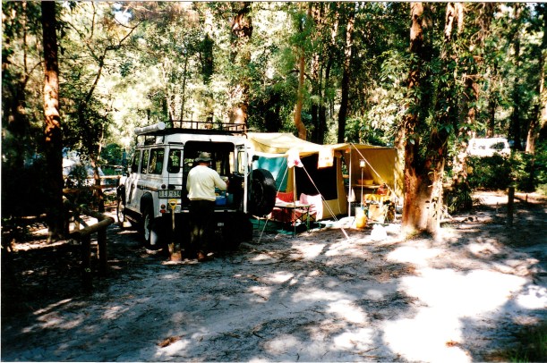
Our camp set up at Lake McKenzie.

Our site was some distance from the amenity block, which we thought was basic, but ok. There were a couple of toilets for each gender, and a cold water shower. There was also a tap supplying drinking water. All that one needs – almost luxurious!

There were also big, heavy-lidded hoppers for rubbish – very dingo proof, and a firewood supply because most campers seem to see it as mandatory to have a bonfire in the bush! We were good little greenies in this environment and used our gas appliances – no fires.

After all the warnings about dingoes, we made sure all our foodstuffs were kept in the Truck. Made sure the lid of the camp fridge, which was outside the tent (as it runs on gas) was heavily weighted down, when we weren’t in camp. We even kept our bedding and clothes in Truck, as we had been warned that people scents could attract dingoes into the tent – and we did not want it to get chewed or torn into by a curious dog!

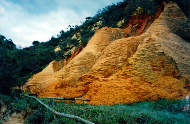
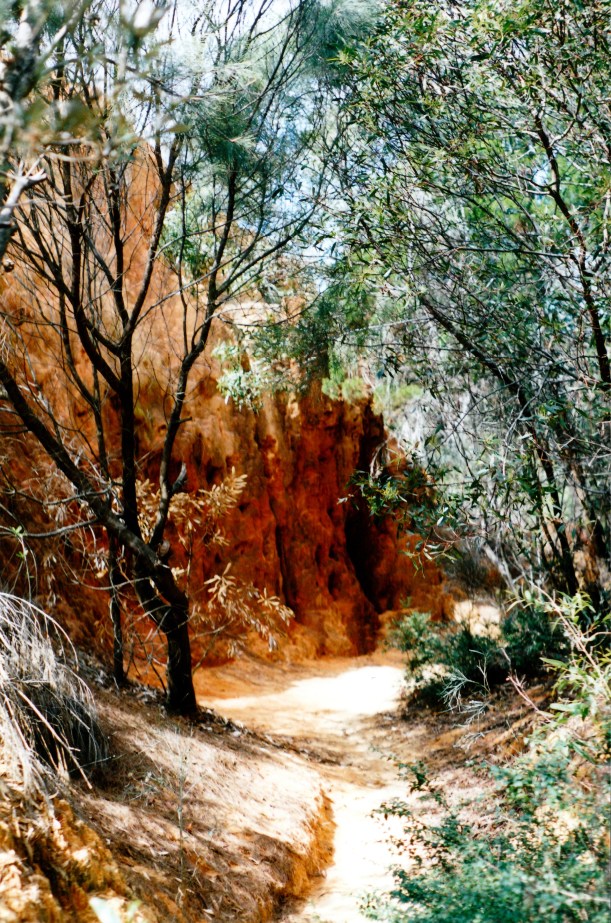
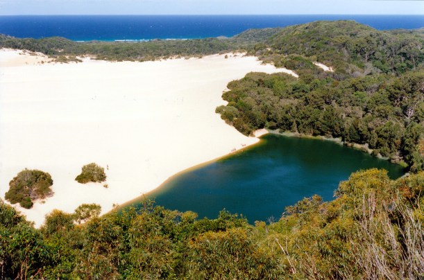
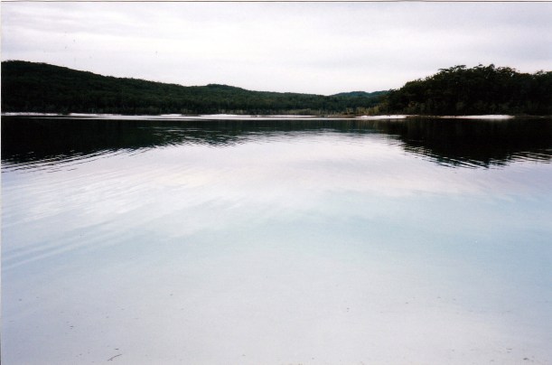
The camping area was about 200 metres from Lake McKenzie, which is one of the most fascinating features on Fraser Island. It is one of the many freshwater perched lakes (above the water table and fed by rainwater). It seems such an unusual feature to find on a sand island.

05-08-1998 05 first view Lake McKenzie Fraser Is.jpg

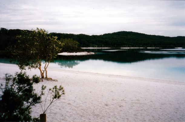
Our first sight of Lake McKenzie

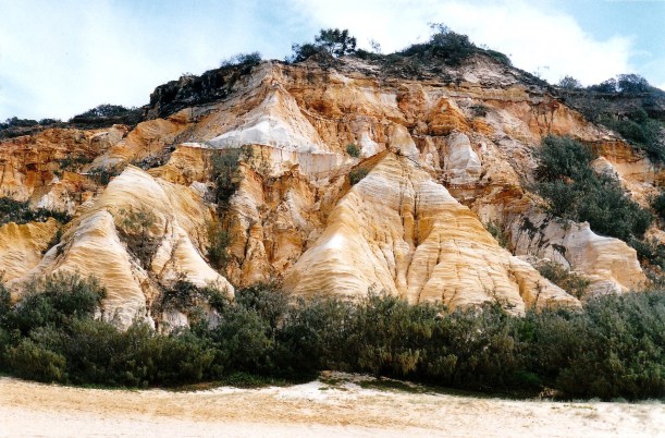
Fraser Island is the largest sand island in the world and has had World Heritage status since the early 1990’s – not long at all. I remember the controversy, back in the 70’s, over mineral sands mining on the island and proposals to expand same. The growing conservation movement in Australia lost the campaign to save the original Lake Pedder in Tasmania, from being drowned, but won the campaign to shut down sand mining on Fraser Island. Seeing the place now, I am so thankful for that.

The island actually was once called Great Sandy Island, until a shipwreck in the 1830’s stranded a lady called Eliza Fraser here, for some weeks.

We found that Lake McKenzie is constantly changing its appearance, depending on the time of day and the weather conditions. It is never the same for more than a few hours at a time. It is absolutely beautiful, and even on our first day here, I was wishing that we would have longer camped by it! We are privileged to be able to observe its constant changing, and feel that the day trippers who are only briefly here are missing out on a wonderful experience.

One morning, I saw mist rising off it; later in the day, in bright sunshine, it was a brilliant aqua colour; at sunset that same night is was a dark purple colour. In the afternoons, campfire smoke drifted across the lake, sometimes making interesting patterns. One afternoon, there was a rainbow coming out of it, before we got the only little bit of rain of our stay on the island. Another afternoon, it was aqua at its shallow fringes and deep ink blue where it quickly gets deeper. We went for a swim and it actually seemed blue to swim in – like moving through dark ink – like nothing I have ever before experienced! Such a magic place.

05-08-1998 07 camp fire smoke over Lk McKenzie.jpg

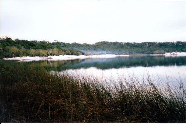
Late afternoon campfire smoke hanging over Lake McKenzie

There were lots of tortoises living in the lake – we could see them stick their heads out of the water to look around, and also see them swimming in the shallow edge water. We even saw some baby ones swimming around, about the size of a 50 cent piece.

We were pleased to find that the Lake McKenzie camp ground is regulated and controlled, as the 1992 guide book that I have says this is one area that has suffered from over use and is very degraded. Clearly National Parks has undertaken significant management and rehabilitation programs, that have worked, since that was written. However, all is not perfect. One tends to assume that people who make the effort and pay the costs to come to a place like this do so because they are “into” the natural environment. Yet they leave rubbish around in camp areas – beer bottle tops and cans, in particular. There is much toilet paper scattered in the bush beside the campground tracks, despite the toilet block nearby! There was a big pile of person poo beside the track when we first walked down to the lake – inexcusable!

After setting up camp, we walked the little way to the lake edge and small beach, along a well used track through the bush. Walked part of the way round the lake, which is big enough to take about half a day to walk right round it. We spied some “new” birds: mistletoe birds, a male scarlet honeyeater, a Lewins honeyeater, a white throated honeyeater.

05-10-1998-03-lake-mckenzie-afternoon

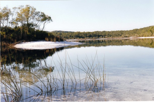
Reflections in the clear water of Lake McKenzie

On the way back, followed a little track near our camp and found a rubbish dump – with a difference. It was a dingo’s storage place. There were a couple of cans of meat which it had been unable to open, with plenty of tooth dents. The remains of milk cartons and bread wrappers showed where it had been more successful. It also had a pair of shorts and a leather shoe – both chewed. We had been told that, apart from tearing tents to get at food, they have also been known to carry off sleeping bags – maybe some of the backpacker ones get a bit ripe?

In our time at this camp ground, we saw the occasional dingo padding up the camp area roads, or going behind the tent, but they never lingered in our area, or made us feel uneasy in camp. In the mornings, there were always several sunning themselves by the rubbish hoppers. At night, there were choruses of dingo howls, near and distant, a beautifully eerie bush sound. We were there at full moon time, which probably made them more noisy at night. In the mornings, there were dingo tracks on the white sand beaches of the lake.

I cooked chilli con carne for tea. Quick and easy to do and only needed two stove burners – one for the chilli and one to cook some accompanying pasta spirals on.

As that first evening wore on, there was quite a bit of noise from the camp sites where the back packer groups had settled. There were several lots of 8 to 10, each sharing a Toyota Troopy. However, they did go quiet about 9.30pm, in line with the camp ground etiquette. It is known that the Rangers are being quite tough on noise disturbance and have sent people off the island. It seems to have had the desired effect!

It is pleasant to be in the tent again, for the first time since John’s hip was done. But this new lilo, that we bought last year, is akin to a water bed that wobbles about and is quite difficult to sleep on. We had discovered, as it grew dark, that we had no mantles for the gas lantern that screws onto the top of a wand that sits on the gas bottle – don’t know where those got to. Miraculously, the existing mantle, despite all the travel, is still intact. It must have been there for years! We tried to use the new Coleman lantern that K had given us for Xmas, but upon reading the instructions (why do we never do this in advance of trying to use something?) that we needed meths to light it. We had brought a bottle of its kerosene main fuel, but had not thought of the primer. It was nearly a very dark night!


Leave a comment

1998 Travels May 7

THURSDAY 7 MAY     TORQUAY

Spent the day getting ready for the Fraser Island trip.

I did a couple of loads of washing.

John had hoped to play bowls in the afternoon, but did not get booked in, in time, which was probably fortunate. On the way back, he bought diesel for 67cpl.

We had to unpack a lot of things from Truck and work out what to take, and what to leave in the van – which was quite a lot! The camping on Fraser is unpowered, so we do not need any of the electrical stuff.

Packed a couple of changes of clothes and enough food for our time there. I planned fairly simple meals.

John put up the small tent, so he could trim some shadecloth we had to size, to go under it to protect the floor from stones and sticks. He burnt peg holes in the appropriate places, then packed it all up again. We took down the van awning to store in the van while we are away – in case of storms.

While John finished packing Truck, I cycled to the supermarket to get some food items needed. I was a bit late going, and wound up riding back in the dark, trying to juggle supermarket bags hanging from the handlebars. I cycled 6.5kms. Not one of my better efforts, especially where the road surface was very rough. We will not take the bikes to Fraser – too much sand for riding! They will join a heap of other stuff to be stored in the van.

Late in the day, people arrived into the on-site van opposite us. They’d just had three days on Fraser and gave us quite a bit of advice and information. They particularly emphasized the need to be dingo aware in camp – apparently the dingoes are very bold about taking anything edible from camps, even to the point of running in and grabbing stuff while people’s backs are turned!

The wild dingoes of Fraser Island are regarded as a pure strain of the species, because they have not interbred with domestic type dogs, like those in most of the rest of Australia. So it is important that they are protected. Unfortunately, like any dog, they will not pass up the chance of easy food, and irresponsible or careless campers have made them into a bit of a nuisance around the camp areas.

I made spaghetti carbonara for tea.

Fairly early night – we were both really tired. Today had been hard work.


Leave a comment

1998 Travels May 6

WEDNESDAY 6 MAY     TORQUAY

We have extended our stay here by a couple of days. It is now $16.20 a night – still get discount, but no weekly rate.

After an early lunch, drove to nearby Howard, some 25kms away via the Toogoom road. There, we did a tour of Brooklyn House, an old Queenslander style home that has been restored from derelict by its current owners. The tour cost $4 each. This was the childhood home of Dame Annabelle Rankin, the first Queensland woman Senator and only the second female Senator elected in Australia – in 1946. It was her father who had the house built. We chose to visit Brooklyn in order to see what one of these classic Queenslanders was like inside.

05-06-1998 02 Brroklyn House Howard.jpg

Brooklyn House – classic Queenslander

The owners seem to have done a great job of restoration of this heritage listed place that was built in 1890. There is much use of cedar and beech timbers, intricate panelling, marble and timber fireplaces. They have some superb old furniture. There were some unusual and beautiful old light fittings. The place did smell musty old though. We were guided around by the lady owner; the tour has to be thus guided because they live in the place.

05-06-1998 01 Brooklyn House veranda.jpg

On a verandah at Brooklyn House; many rooms open directly onto it

We looked around the rest of Howard, which has cheaper houses and land, but not much else.

Went on to Maryborough. At the excellent Tourist Info Centre there, staff told us what to see in the couple of hours we had till dark. We went into the centre of town and walked in the gardens there, beside the Mary River. Saw a most impressive, huge old strangler fig.

05-06-1998 03 Strangler fig Queens Gardens Maryborough.jpg

Huge strangler fig in Maryborough gardens

05-06-1998 04 John inside the big fig.jpg

John is standing inside the root system of the strangler fig

Went down to the historic Wharf Precinct. The restoration works of the many heritage buildings is excellent. The port on the Mary River was once a huge concern; they even built boats there. It was a real gateway to the interior pastoral lands before the railways came.

Drove back to Hervey Bay via River Heads Road.

We have decided that we will go to Fraser Island, after all. The weather is definitely improving and the forecast is reasonable.

At the caravan park office, was able to book onto the barge from River Heads to Wanggoolba Creek on Friday, returning from Moon Point to the Urangan Marina on Tuesday. That will give us four nights and kind of five days on the island. We can store the van here for $2 a night, which seems very reasonable, as we can leave it on site, with the power connected.

Tea was small whiting fillets that we bought and home  made fries. I still think that there are too many bones in whiting and don’t much like eating it. John eats the bones too!

Much planning to be done now, for the Island trip. It is exciting! This is the first of the “big goals” for the Big Trip!


Leave a comment

1998 Travels May 5

TUESDAY 5 MAY     TORQUAY

There was really consistent, heavy rain through the night. We had several inches.

We did not get up until 10am, as it seemed darker and earlier; cannot see the clock from the bed.

There were a couple of dribbly leaks in the back corner of the van, but we could not tell why or exactly where the water came from. The wide back window was slightly open. Outside, I climbed up on our little folding ladder to check it out. The rusty rivets on the lower rung gave way and I came down awkwardly, spraining an ankle and skinning the shin bone. I got quite a shock and it hurt like hell. Ice treatment was needed. In the course of fishing out some frozen food to put on the leg, John decided a fridge defrost was needed – it was quite iced up. The cold – and the leg up for a couple of hours seemed to just about fix things. I watched while John did the fridge defrost. Our Vitrifrigo compressor fridge does not automatically defrost – we must turn it off and leave the ice to soften, then scrape it off. Too much of an ice build up makes the fridge cycle more and use more power. While the defrosting is happening, I put the contents of the freeze box in a bucket, with newspaper and towels over it, so our meat and fish do not defrost too.

After lunch, I strapped the ankle – it is the right one, which is very weak anyway, after multiple past sprains while playing sports, and when bushwalking.

Drove to Target to get new thongs. I also bought a small blue china teapot, so I can make proper green tea. It seemed expensive, at $13.

We checked out the cinema centre for a Titanic screening, it being cheap night. It would be $7 each, but the film did not start until 8.30pm. Decided we did not want to leave Truck parked in the dark in that part of the town! We would stay in and watch a video instead.

Went grocery shopping. Quite a big stock up and spent $105.

We are due to leave the park tomorrow, but decide to stay a bit longer. We are really undecided about going to Fraser Island, given the weather. Floods have closed the Bruce Highway between Maryborough and Gin Gin; traffic must detour through Bundaberg.

The reason we slowed down, after sitting out Easter at Tewantin, was to let the holiday crowds disperse from Fraser Island, and let the weather be good for such a visit. But it is hard to get a run of dry days. Still, it is somewhere we really want to go and I am loathe to leave here without doing so, even if we do get wet!

There are ants everywhere. Forget the Weather Bureau and its modern technology – just look at the ant activity! If they are building big, high mounds, it might be time to think about going elsewhere, while you still can! Ants are being a pest around our outside table and chairs – little bitey ones. We have some in the van, too; this has been a problem since Canberra. Suppose that staying in one place for any length of time lets them figure out ways of getting in. We just have to keep spraying and using Baygon whenever we can work out their entry points.

There was some more rain in the early evening – short but heavy.

The ducks have not been around today. The creek/lagoon/swamp next to the van park has risen noticeably. Maybe there is enough new food there to keep them occupied? Maybe they don’t like rain? Maybe they know something we don’t?

Tea was pasta and my best ever tomato sauce, followed by bought tofu icecream and ginger berry topping.