This Adventurous Age

Adventures travelling and working around Australia.


1 Comment

2013 Travels August 31

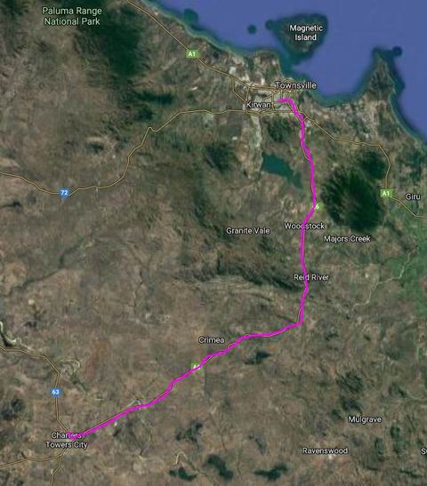
SATURDAY AUGUST 31     TOWNSVILLE TO AIRLIE BEACH     290kms

Pulled out of the Black River Stadium camp just before 9am.

Both the GPS and I managed to miss the turn off onto the Townsville Ring Road, so we had to find a place on the highway to do a U-ey, in Saturday morning traffic. Driver was not happy. I reckoned the signage, coming from the north, had not been clear – that was my excuse, anyway. For the GPS there was no excuse!

We refuelled at the very convenient Woolworths servo at the big roundabout. $1.529 cpl. Found the way out again, first try, this time.

It was a hot day, making travel uncomfortable.

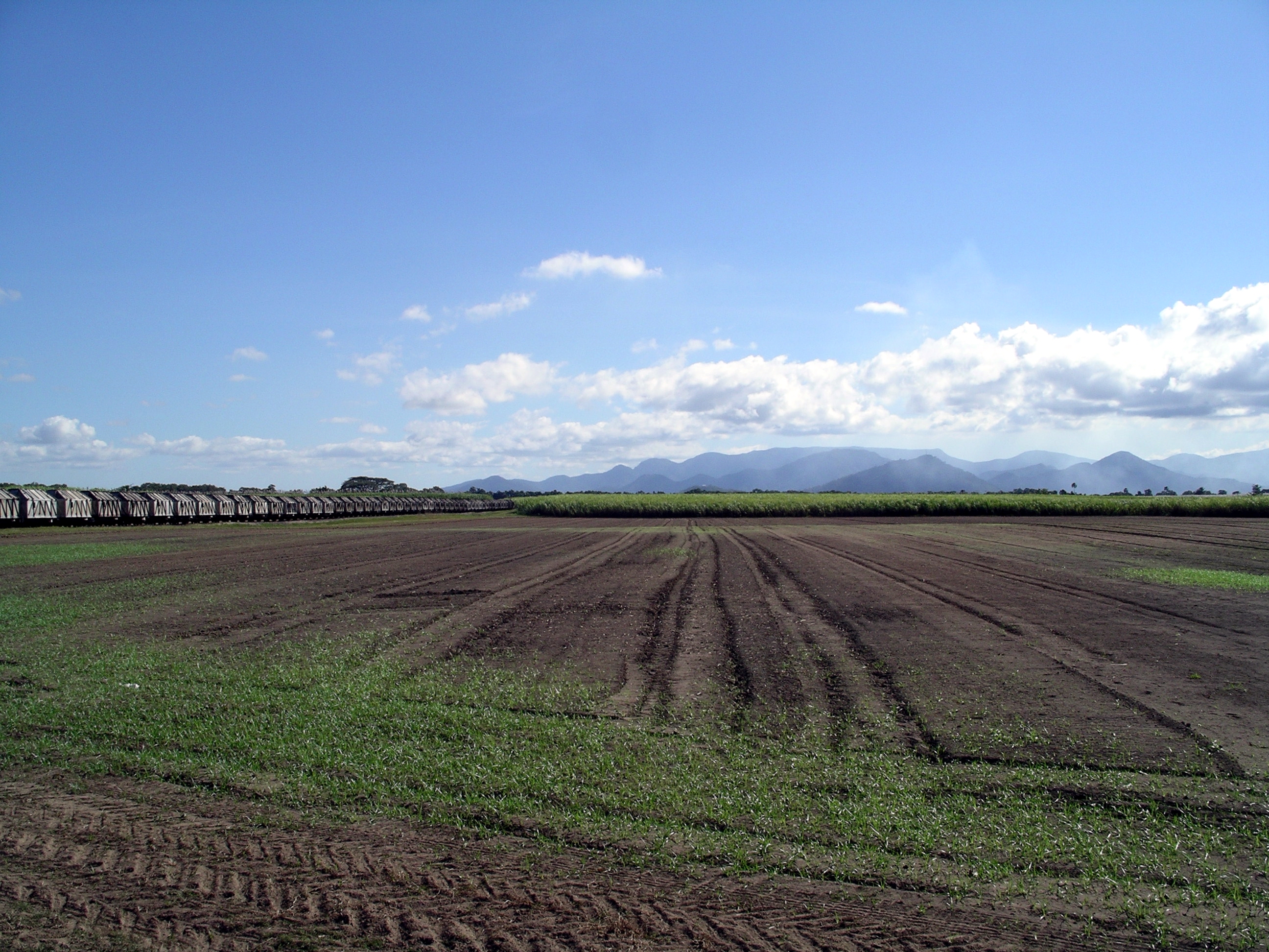
There were roadworks at regular intervals south of Townsville, and we spent a lot of time waiting in traffic queues. Seemed we hardly got up to speed after each stop, before we were pulled up again.

Will Bruce Highway roadworks ever be finished?

Unfortunately, these hold-ups started virtually on the Townsville outskirts, coinciding with the Driver’s urgent needs for “comfort” stops, every ten minutes or so, for the first hour or thereabouts of travel. The usual pull ups beside the road so he could exit Bus were not possible in the lines of traffic. So, while we were stopped, and the matter was becoming urgent, I went back to the kitchen area  and found an empty plastic jar – with lid! Served the purpose…. Being higher than the surrounding traffic had more than one benefit…

The section between Townsville and Ayr was definitely the worst for roadworks that we had encountered on the Bruce.

Passed the NAP mango packing shed at Giru, where we’d worked for six weeks, back in 2002, me packing mangoes and John on the sorting tables. We used to drive out every day from the caravan park in Ayr, so that section of road was familiar.

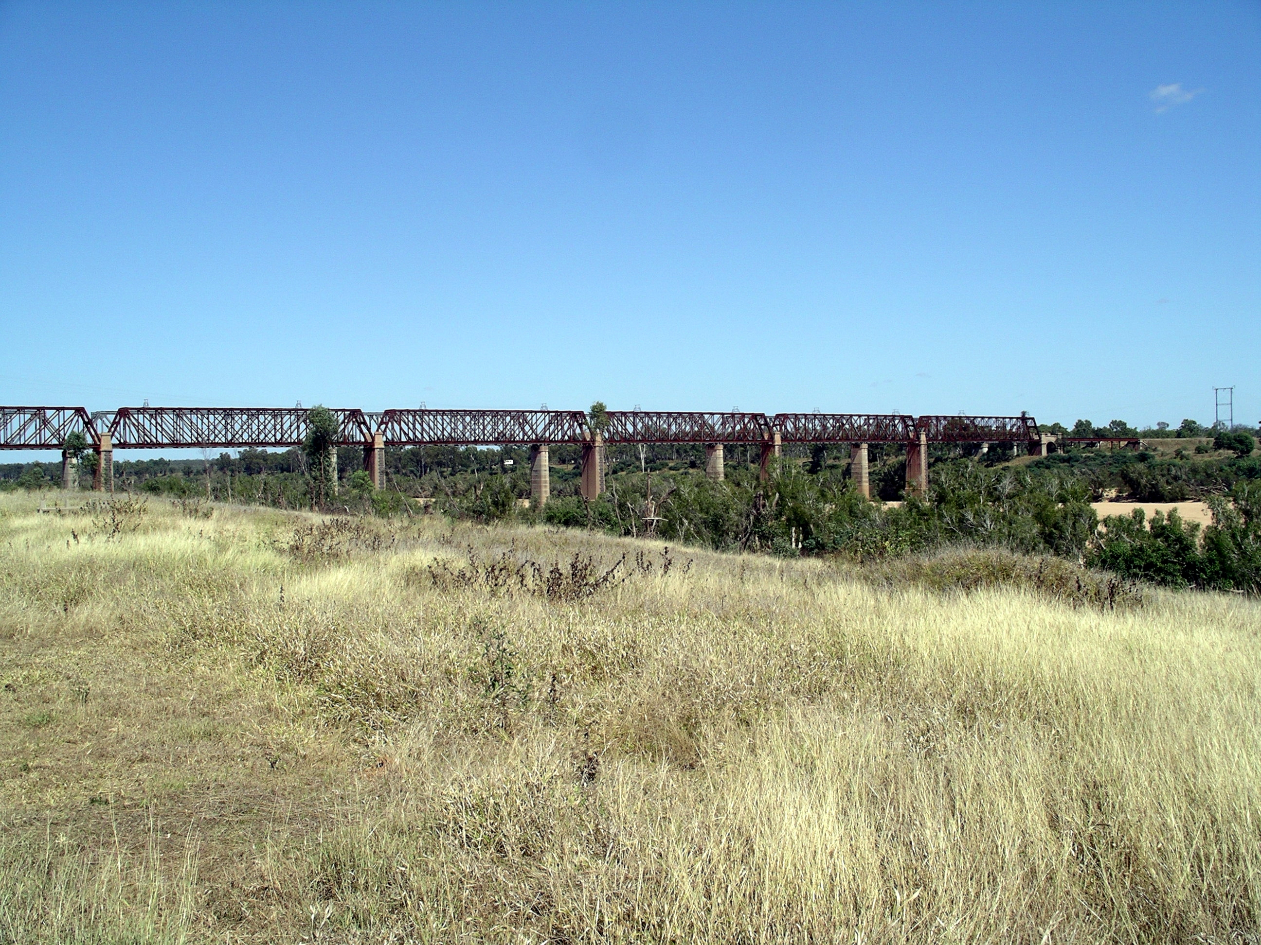
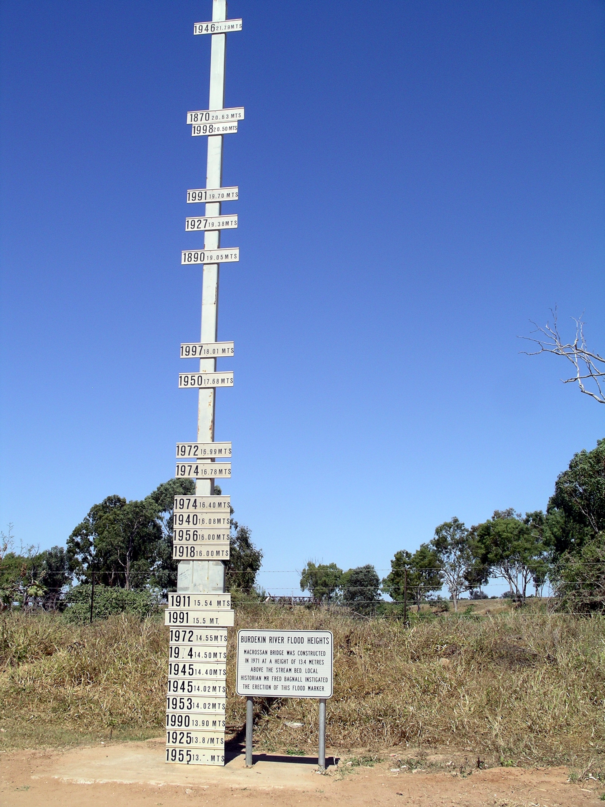
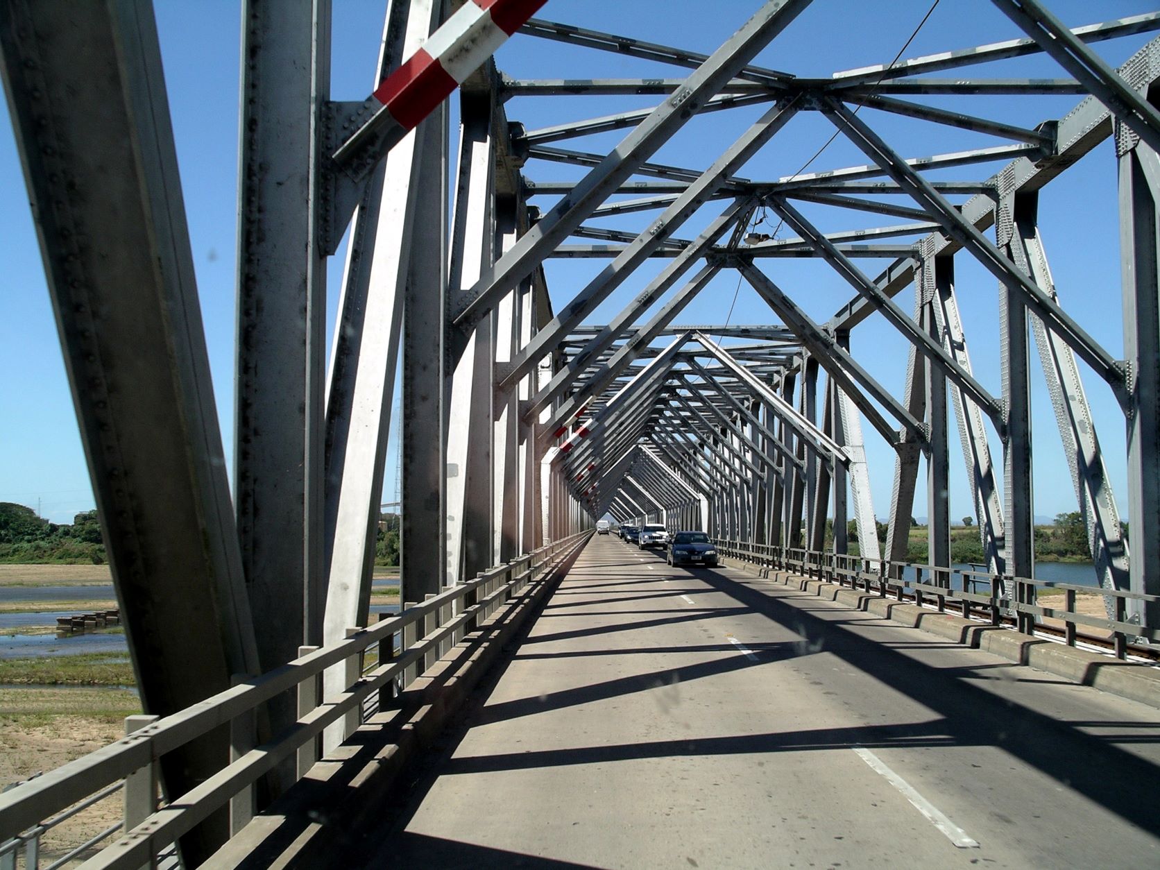
Crossed the Burdekin River on the dramatic steel girdered bridge. Looking at the small stream below, it was hard to credit that this bridge has at times been inundated by the river.

Unusual bridge structure across the Burdekin River
On the Burdekin bridge

The Inkerman Sugar Mill was just south of the river. I looked at sugar mills differently since our sojourns at Forrest Beach. Inkerman was dull, compared to the Victoria Mill complex.

Stopped at the Guthalungra Rest Area for a leg stretch and a little walk around for Couey. This was a pleasant, well set up U shaped road beside the highway, with toilets. There were several rigs there that looked as if they were already set up for the coming night – and it wasn’t even lunch time. I reckon it might have become pretty crowded later.

Now that he was feeling a bit better, John had, this morning, agreed that we could continue along the coast, and slow down a bit, rather than take the faster inland way home from Townsville. I suggested that we stay at Airlie Beach, which we hadn’t visited since 1998, and which we’d really liked then. I was able to phone and book into the park we’d stayed at then.

We turned off the highway before Proserpine, and took a pleasant short cut, on back roads, through to the Airlie Beach road.

The back way to Airlie Beach

We couldn’t believe how much the town and surrounding area had changed in the intervening years. In 1998, Airlie Beach was a busy little backpackers’ mecca, but still more village than anything else. Now sprawling suburbia had spread back out through Cannonvale and towards Proserpine. In Cannonvale, we passed a shopping complex and a Bunnings – always an ominous sign of development, as was the multi-lane road.

There used to be a spot on the road into Airlie Beach where one crested a rise and the superb vista of the sea and islands suddenly appeared – it was a real “wow” spot. That had gone now, with changed roads and harbour redevelopment – a pity.

Airlie Beach itself was now dominated by multi-storied buildings that spread up the once-wooded hillsides. The backpackers were still evident, and tourists, just lots and lots more of them.

Roadworks were happening, to change the centre of the town and, combined with re-routing due to a fun run, the jumble of signs and barriers was really confusing. There was traffic going every which way. We missed the detour we should have taken, and finished up driving along a very narrow road through the shops area and, I suspected from the strange looks we received, going the wrong way along a one-way stretch.

Our chosen park – the Airlie Cove Tourist Park – was through the town centre, on the road to Shute Harbour. The park was now more developed and up-market, but still with lots of lovely lush, green gardens and trees. We were allocated a very private, pleasant en-suite site, towards the back of the park, for $46.80  a night, after Big 4 discount. Tourism had definitely moved Airlie Beach prices into the big league!

We were given a sticker to put on the rig, to show we “belonged”. The receptionist said they had problems with backpackers sneaking in and staying without paying. I wondered why they hadn’t just installed some sort of boom gate like some other parks have.

I’d committed the cardinal sin – yet again – when phoning ahead to book, of neglecting to ask whether there was good TV reception and internet. In the dog house again… kind of literally! John was offered a cable to connect us to a TV signal. When we were set up, the cable had to come inside through one of the front windows – along with assorted insects, mostly of the biting variety.

After setting up, took the car and did a brief food shop, because the driver had decided he wanted home made hamburgers for tea. He also checked out the bowls club and arranged to play tomorrow.

Just after dark, I took Couey for a walk along the internal road inside the park perimeter – on her lead, of course. I noticed a Britz hire van parked a little way along the road opposite us, where there were some grassed unpowered sites. As we came back, there was a couple using the nearby camp kitchen – sounded like it was German they were speaking. I assumed they were from the unpowered site and thought no more about it.


Leave a comment

2009 Travels August 21

FRIDAY 21 AUGUST     FORREST BEACH TO CHARTERS TOWERS   270kms

We were up at 6am, courtesy of a very loud kookaburra, right by the van. It was a more pleasant way to wake up than via the alarm clock.

Did a steady pack up. John checked the tyres, all round. He took his photo album of all the furniture he’d made, to show N. We were invited by N and her family to go round and visit them if we were back this way, next year.

At this stage, our thinking was that next year’s trip would bring us back to North Queensland. We still wanted to go back to Cooktown and Cairns, and there were some lovely coastal places to stay between Townsville and the Daintree.

Had a brief stop in Ingham, for me to return library books, and left there just after 9am.

Proceeded mostly uneventfully southwards – the familiar route! For the last 30kms or so before the highway became multi-lane, north of Townsville, we were caught in a tail back behind a SA registered Supreme van. He was another of those whose speed varied greatly, according to whether there was any chance that someone might be able to pass him. He ended up with about thirty vehicles behind him, including some trucks. Moron!

We would miss the sugar country, with all its interesting harvest activity, and the green-ness of it.

Goodbye to green cane fields and the backdrop of the mountains

The new Ring Road around Townsville made that section easy.

The climb up the Dividing Range from Townsville is the easy way to reach the inland. For much of the way the gradient is so gentle that the railway runs close to the highway.( Railways can only manage gentle gradients.)

We stopped at Macrossan, by the bridges over the Burdekin River, for lunch – which I’d packed this morning – and a bit of a walk around.

Burdekin River bridges at Macrossan

The old and new railway bridges were close to each other and high above the river. The impressive old structure was built in 1899 and designed to be above the highest flood level recorded to that time. The fact that it is so high above the river bed level, showed what huge floods this river has.

The advent of new, heavier diesel engines created the need for a new bridge, which was built right next to the old one in the 1960’s.

Old bridge in front, piers of new bridge evident behind it

On the western side of the road bridge across the Burdekin was the flood marker – unique in the levels it showed.

The railway bridge in the background

Standing by the marker made us feel awed enough, by the water levels that reached well above where we were. But the marker itself stands some 13.4 metres above the bed of the Burdekin River – now that makes those floods truly awesome. I couldn’t begin to imagine how much water goes down that river in flood times.

The floods earlier this year reached  20.75 metres on this marker, a metre below the record flood level of 1946.

……and they left room at the top for a new record!

Refuelled on the way in to Charters Towers, then went on to the Dalrymple Tourist Park, where our powered site, after Seniors discount, cost $25.65. The site was partly shaded, and we were able to stay hitched up.

We were setting up by 1.30pm, after which John had a nap.

I defrosted the fridge again. The heat and humidity we’d had at Forrest Beach seemed to make it ice up faster than usual. At least, I hoped that was the reason.

The amenities block here was spotless, sparkling clean and modern – much appreciated after what we’d had for the last month!

It was hot – around 30 degrees in Charters Towers today. It was forecast to be warmer over the next two or three days. There was news of bushfires in the Brisbane area.

We had apostle birds around our camp – now we knew we were inland again……

Tea was threadfin salmon from the freezebox, in beer batter, with fries.


Leave a comment

2009 Travels June 12

FRIDAY 12 JUNE     CHARTERS TOWERS TO TOWNSVILLE     135kms

We did not get up until 8.30am. One of us was feeling somewhat seedy – and it wasn’t me.

Left the park at 10.15, after having a final, breakfast  chat with H and M.

The drive to Townsville was pleasant and interesting.

Only a few kms out, the highway crosses the Burdekin River, on the high-up Macrossan Bridge. Downstream from the current road bridge are the spans of both the old and new railway bridges, elevated high above the river. Just before the bridge was a display marker that showed the heights and dates of all the floods, We were past that before I realized, and the driver was not prepared to turn around, or stop for photos.

The highway passed through some hill country but was a great one for driving and towing – absolutely no dramas. Given the dicey brakes, that was a relief. We had not come down to the coast that way, before, and decided it was definitely the best way through the Great Divide, north of the NSW Hunter Valley route, and south of Cooktown.

The hills of the Bowling Green Bay National Park, to the right as we neared Townsville, were quite dramatic in the distance.

We drove straight to the brake service place, because John wanted them to check the van brakes, while it was still attached to Truck and thus mobile. Finding the place, with just a map in an information brochure, was a bit fraught. Then we had to do a couple of circuits round the block, before John found a place he could park the rig.

He spoke with the brake people. They had a mobile service that could come to the caravan park to look at the van brakes, if necessary, but they were too busy, right then, to do anything. It was also lunchtime! However, the man John spoke to seemed to know immediately what the problem would be, with the Truck brakes. He said getting parts might be a problem!

Thus, to the Lakes Caravan Park. More navigating! We had not stayed here before, and I had chosen it as being fairly central, in the event of being without transport for a while. It was close to the Castletown shopping complex and a whole strip of fast food outlets. There was the usual traffic noise, as it was on a main road.

All the sites here were en-suite ones. They cost $40 a night, but the seventh night was free, so our ten nights cost $360. The park contained a mix of permanent residents and tourists – not always an easy mix. It had frontage – fenced off by a high fence – to a series of man made lakes. Sites with an outlook over these were very pleasant, indeed, but ours was not one of them. One probably needed to book further ahead than the day before, to get one of those, at this time of year, especially as Townsville is a centre where a lot of southerners come for two or three months, over winter.

Our site at The Lakes

We looked out on a couple of permanent set ups and a little laundry area. But there was some grass behind us. The en-suite was showing its age, but clean and adequate. Overall, it was comfortable enough, and would serve our purpose, while things got fixed.

After we had set up,  John was straight onto the internet and phone, chasing the Truck brake part the brake service man had mentioned as “probably” being needed. He found out that our former Landrover Service Centre in Melbourne could supply it, as could a place in Brisbane that a friend once told John about. So, at least that would not be a problem – if it was what was wrong!

I navigated John to the West End Bowls Club which, on my very limited map, was closest to where we were staying. It was closed, kaput, defunct – all cemented over!

From there, we continued across through town, with me frantically trying to match up little map with the reality outside Truck. Our goal was the fishermen’s marina fish co-op shop, which we’d visited back in 2002. It was across the Ross River and the railway lines, almost to the mouth of the Ross River, through one of the older sections of the town. I bought red emperor for tonight’s tea, some crumbed whiting for John for tomorrow night, and a piece of barra for me. All up cost, $23. Very reasonable. I resisted their attractively priced prawns – for now. I was given a loyalty card that would get me 10% off my fifth purchase made. We expected to be back – several times – before we left here.

Had our happy hour sitting outside. There were bush curlews calling from by the lake – wonderful and unexpected right in town.

The day here was warmer than any we’d had, to date. and quite humid. The night was a very comfortable temperature.

Later in the evening, as we were watching TV, there was a series of sirens heading past. I missed the bush noises!


7 Comments

2002 Travels October 21

MONDAY 21 OCTOBER   TOWNSVILLE TO MIDGE POINT   300kms

From other travellers, I had heard glowing reports of a caravan park at Midge Point, near Proserpine. It seemed a more peaceful alternative to staying at the nearby backpacker haven of Airlie Beach. This was an ideal time, I thought, to satisfy my curiosity about this place.

We drove south from Townsville, passing through Giru and wondering whether the mango shed work there would really eventuate. Initially the way south from Townsville was quite hilly, but closer to Giru the land flattened out, with just the Dividing Range in the western distance. Great fields of sugar cane appeared and then some mango plantations.

From Giru to Ayr was through flat, sugar cane growing country. Ayr was a good sized town. We would get to know it better if we came to stay here. Just south of Ayr, we crossed the impressive metal bridge over the Burdekin River. It is all metal girders and struts and the overall impression is rather temple like. This bridge is almost as long as the Sydney Harbour Bridge and testament to the sometimes huge floods of the river, with its large catchment area.

Just across the river was the large Inkerman sugar mill.

Beyond Home Hill township, the sugar cane country soon gave way to grazing lands – not as interesting to drive through. There were some pockets of crop land though, especially around Bowen, and closer to Prosperpine.

The highway skirted Prosperpine, then several kms south of the town, we turned onto a road that would take us past the Laguna Quays resort development to Midge Point.

We booked into the Travellers Rest Caravan Park – $97 for the week, after Top Tourist discount. Then we set up in what appeared as a very attractive, lush, green, shaded, tropical park.

Resize of 10-24-2002 02 Midge Point CP.jpg

Midge Point Caravan Park

There were almost no other guests, a fact that I initially put down to the time of year, well outside the tourist season.

There were peacocks wandering about the grounds. A male made us a great display of his tail feathers.

Resize of 10-23-2002 peacock threatened by blue tarp.jpg

Peacock display – from the wrong side

We were not far from a beach, just down a little walk track, but decided to leave exploring until tomorrow, and just relax for the rest of the afternoon. However, sitting outside and enjoying the lush surrounds did not last for long, as the bities soon arrived. We retreated inside.

Resize of 10-21-2002 to mp.JPG


Leave a comment

1998 Travels December 1

TUESDAY 1 DECEMBER     CHARTERS TOWERS

It is the first day of summer. Up here that is, officially, the start of the cyclone season.

We visited the Tourist Information Centre, where I added to the information I’d picked up previously, in other places, about this area and places further south we might go.

Then we walked and looked at some of the superb old buildings. John went and browsed in the Mining Museum; I wandered about, window shopping and put in a film for processing.  Picked it up after an hour and was satisfied with the photos.

12-01-1998 01 Charters Towers Stock Exchange building.jpg

The Stock Exchange Arcade and other grand buildings

We inspected the old Stock Exchange Arcade, which is superb. Yes – Charters Towers was so important because of its rich gold mining that it had its own stock exchange, from 1890 to 1916. This facilitated the trading of shares in the various mining companies, on the world stage. The arcade has an intricately tiled floor, and there is a barreled vault roof and stained glass use.  There are little shops tucked in behind columns, inside. Maybe these were once stock brokers’ offices?

12-01-1998 04 stock exchange building c towers.jpg

Inside the Stock Exchange Arcade

After lunch we did the tourist drive, as outlined in some of the gumpf I collected. This took us out to the weir on the nearby Burdekin River. There was a lot of water pounding over this – quite awesome to look at. It would be tremendous in a flood time.

12-01-1998 07 dam burdekin.jpg

The Town Weir on the Burdekin River

12-01-1998-06-burdekin-r-down-from-dam

Burdekin River downstream from the Town Weir

The rest of the drive was just so-so.

There was a lot of lightning happening, within the clouds to the SE, later in the afternoon.

After tea of steak, salad and mushrooms, we drove to the Rotary Lookout to try – unsuccessfully – to take photos of the lightning.

I really like that this town is preserving and maintaining so many of its grand old buildings.