This Adventurous Age

Adventures travelling and working around Australia.


Leave a comment

2000 Travels July 18

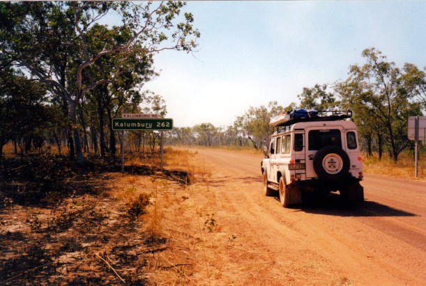
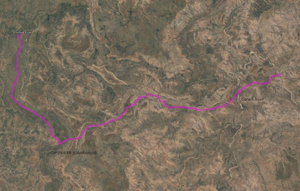
TUESDAY 18 JULY   DRYSDALE RIVER STATION TO THEDA STATION   160kms

It was another hot day.

We were up at 6.30 again, and away two hours later, after topping up our water containers.

We drove into Miners Pool to have a look – 3.5kms from the main road. It was a much bigger camp area than I remembered, strung alongside the waterhole, and with pit toilets. It would have been a fairly pleasant place to stay, after all.

The Kalumburu road was still closed to vehicles over 7 tonnes, beyond Drysdale River HS, and was listed as 4WD only. It is usually later to open than the main Gibb River Road, and also later to be graded.

We encountered several muddy sections of road. After going through one of these, there was much grinding from under Truck. We stopped, looked, drove it back and forth a few times. John decided the noise was coming from the left rear wheel. He jacked Truck up and took off the wheel. The shaped metal plate that protects the brake was buckled and rubbing on the wheel. The bolt area was still attached, so part of it had just torn off! John took it off to stop it rubbing any more and ensured what was left was clear of the wheel.  He buckled a bit of the Truck frame using the jack – did not have it in at the right angle.

07-18-2000 01 nasty noise in wheel.jpg

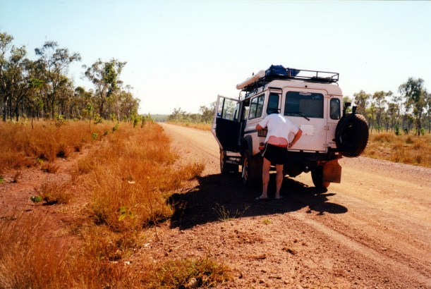
Having some difficulties – checking out the noise from the wheel (and losing shorts!)

We passed the turn off to the Mitchell Plateau and continued on to Theda Station, through some Livistona palm stands. Mostly we passed through typical Kimberley savanna scrub and woodlands.

The road was great in sections, corrugated and dusty in others. It was not fast driving. There was very little traffic.

We reached Theda at lunchtime. There were two other travellers’ vehicles there, having tyres repaired.

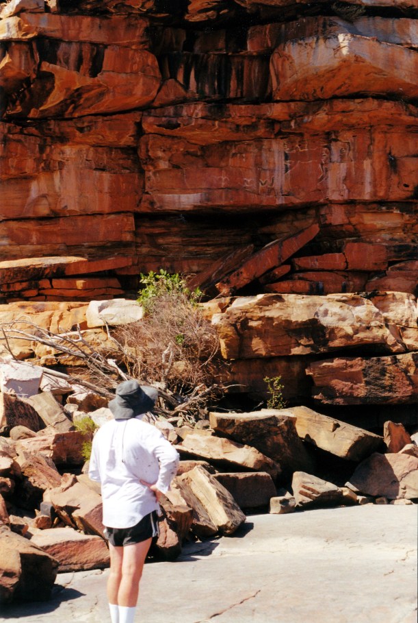
The Theda person said we could bush camp at their Turtle Pool site, for $14 a night, but it was only available for four nights. Their other dispersed camp sites were not available as the tracks were still too cut up. The tracks to Worriga Gorge and King Edward Falls, that we’d read about and thought of driving, were still inaccessible – but we could do their Bradshaw art tour for $55 each! Hmmm – we would need to think about that.

He also said that a large freshie croc lived in Turtle Pool!

I bought magnets and postcards.

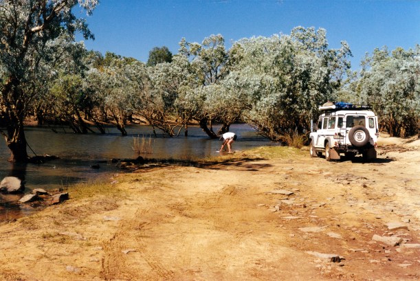
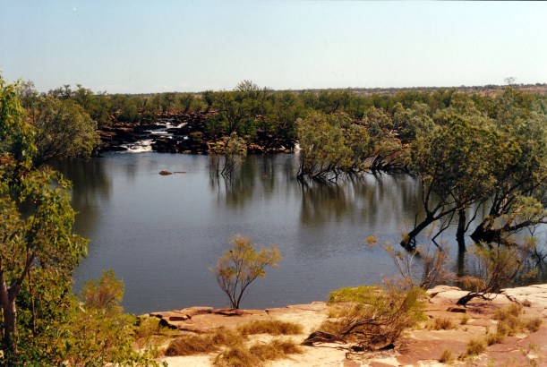
We drove out to Turtle Pool, about 7kms away, crossing the Morgan River, which was shallow at the ford and not very wide. The track was rather basic.

07-18-2000 morgan river at track ford.jpg

Morgan River,  taken as we forded it

07-18-2000 03 track to Turtle Pool camp.jpg

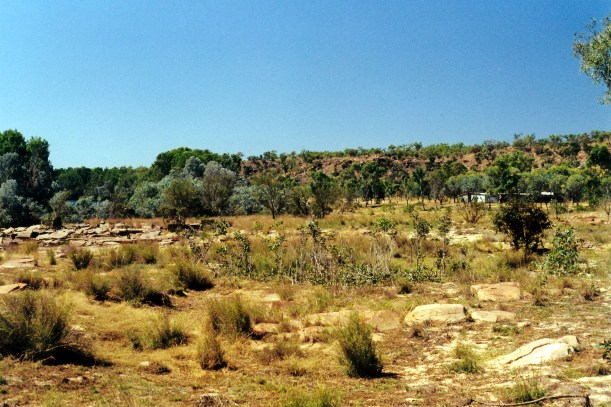
The track to Turtle Pool

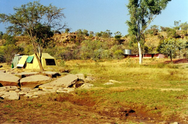
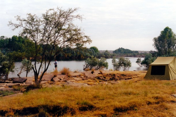
We set up the big tent, in a shaded part of a clearing, not far from the river, then had lunch.

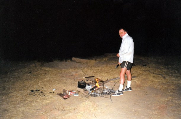
John had a sleep for a while, then he fished. Caught a couple of little somethings – bait?

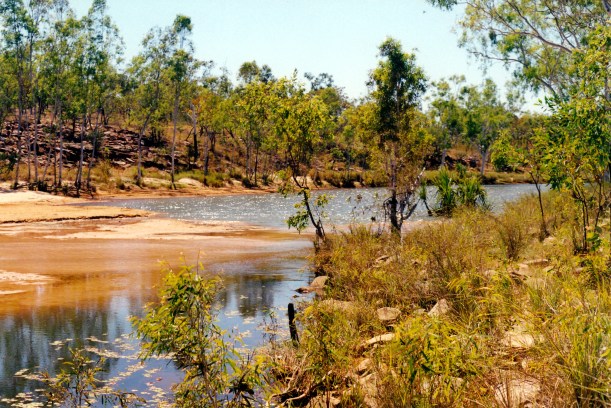
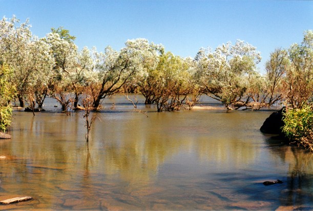
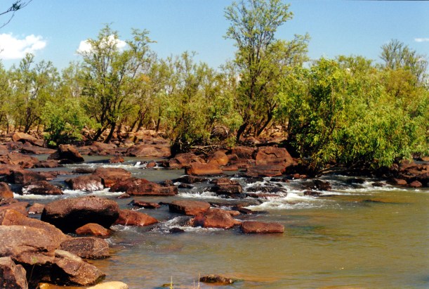
I went for a walk, exploring along the river for a little distance. Turtle Pool was a lovely, long, wide stretch of the Morgan River – it was a serene spot.

Tea was the last of the corned beef, potato, some salad.

It cooled down really quickly once the sun set. We discovered that there were mozzies here!

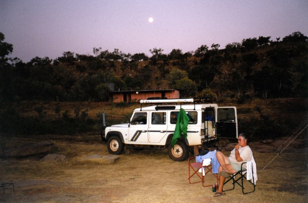
John took the lamp and went off to fish, which left me with nothing to do except sit and stare into the darkness! Even with light, I have found the evenings a bit boring – miss having books to read.

Eventually the moon rose.

John returned with no fish. We turned in. There were lots of night noises – splashes from the pool, night insects – but we slept well.

07-18-2000 to theda


Leave a comment

2000 Travels July 17

MONDAY 17 JULY   JACKS WATERHOLE TO DRYSDALE RIVER STATION   188kms

We were up at 6.30am, and away at 9. That included a stop at the store to buy a tea-towel, a Tshirt for John and one for K for Xmas – because it has a big barra on the front.

It took John longer than usual to pack the Truck because he had to work out how to position the big water container so we could fill it at the Durack River crossing, upstream from here. We wanted to fill it where the water had the best chance of being unpolluted at all.

After Jacks Waterhole, the GRR was corrugated, with bulldust patches, for a way. then we got onto grey slaty material and that was much better going. That proved to be a pattern – the red soil road sections were cut up, the grey harder ones better.

These days, with its rapid growth as a tourist route, there is constant work (in the Dry) to improve the road and keep it in reasonable condition – or try to!

We could see that it has changed since ’93 – it was easier travelling now.

We could also see that some of the places one could bush camp back then, are now prohibited for camping – according to our booklet information. It also seemed, from what we saw, that plenty of campers ignore such prohibitions.

There were several water crossings, none higher than about half way up the wheels.

07-17-2000 01 durack r ford on grr.jpg

Approaching the Durack River crossing

We stopped at the Durack River and filled the water container. This was obviously a place where people camped.

07-17-2000 02 getting water Durack River.jpg

Filling water container at the Durack River ford – from upstream!

We stopped at Russ Creek for morning tea. In ’93 we had an overnight camp here. The creek is much higher than it was then, and the area where we camped is obviously very frequently used, now – and not left very clean!

07-17-2000 03 russ ck;1993 camp. more water now.jpg

About 110kms west of Jacks Waterhole, we turned north onto the Kalumburu road.

07-17-2000 04 cnr grr and kalumburu rd.jpg

Corner Kalumburu and Gibb River Roads – and lots of red Kimberley dust

Just a short way north of the corner, was the ford of the Gibb River. This was obviously another popular camp area.

This road was much rougher, with long sections of corrugations and bulldust. It was rather reminiscent of the Cape York road.

We reached Drysdale River Station at lunchtime.

The brakes were grating with mud/water/dust as we arrived!

We refuelled – $1.30cpl. Paid $16 to camp the night there.

John would have preferred to go on and camp at Miners Pool, just a little further, on the Drysdale River, but I remembered that it had not impressed us all that much, last time we came this way. Of course, with more water around now, it might have been nicer. It would have cost us $8 to bush camp there, whereas here we had tapped water, showers, toilet.

There was a big workshop at Drysdale River, doing a steady trade in vehicle repairs, including on an OKA with clutch problems. The workshop kept going until well into the evening.

We were on our own in the camp area – a fairly ordinary but grassed area – until about 4pm, and then lots of campers rolled in, so it became quite crowded.

07-17-2000 05 drysdale r camp.jpg

Our dome tent tucked in under the trees at Drysdale River Station

We only put up the dome tent – quick and easy for one night.

From the phone box at the shop complex, phoned K and left message where we are.

Tea was cold corned beef, potato, salad.

It had been another hot day, but cooled enough after sunset for us to need long trousers and windcheater to sit outside.

The moon was full again. We missed the night time curlew calls we’d had at Jacks.

07-17-2000 route.JPG


Leave a comment

2000 Travels July 16

SUNDAY 16 JULY     JACKS WATERHOLE

We were woken by a really red sunrise, glowing into the tent. However, I was too sleepy to get up and go take a photo of it! I think the smoke from all the burning off is responsible for the red.

After breakfast, we went walking again. Upstream, this time.

07-16-2000 03 Durack River light.jpg

Durack River. Brown line across trees show line where water was up to for a time

There were not the cliffs of the other direction, that we had yesterday, but were still some rock shelves and jumbles of stone, and a steep slope on the far side of the river.

We saw some birds that proved hard to identify: olive green with a smoky red upper tail and back, and some red in the wings, a finch-like face, a dark beak. They were after insects or seeds. Seemed to have elements of both the Crimson Finch and the Firetail. It remained a mystery.

We walked as far as some rapids in the river – yet another great outlook. We sat on the rocks for a while, just looking and listening.

07-16-2000 01 other end Jacks Waterhole.jpg

Upstream rapids where river widens to become Jacks Waterhole

On the walk back, detoured via the store/office. Looked at the detailed maps of the area that were displayed there, and talked with the lady manager. They leave in November, while the road is still passable, go to Qld for the summer, and return at the end of the Wet. She said that his year it had been such a big job to remove the mud from the buildings – the uneven stone floors mean that shovels can’t be used. It must all be hosed and broomed out. Her husband has staked out a claim on some of the area – he wants to build a stone house up on the bluff above the camp area (someone who thinks like John!). But she says it is not for her, and the aborigines will object to the claim, anyway.

07-16-2000 05 durack river camp.jpg

The floods earlier this year reached inside the amenities block shown

We spent another quiet afternoon at camp.

A plane that had flown over, low, in the morning, had in it a German lad who is working here. We were talking to him later in the afternoon. The plane had flown out of Home Valley because the Durack River airstrip had not been repaired after the Wet. He said they’d flown for nearly two hours – but it affected his stomach!

There was fire somewhere nearby. We could smell it. Either a burn off or a camper’s fire that had got away. It is hard to tell, sometimes, in this country.

07-16-2000 04 durack river hs flooded to 1m in 2000

All this area was under water earlier this year – it was up to a metre deep in the building  shown

A large tour bus came in, during the afternoon. About 30-40 people in an ordinary bus. It was a real mix of people and thus interesting to watch them. There did seem to be some really obnoxious types amongst them, though – loud and opinionated.

I cooked a piece of corned beef for tea. It was ok, and will do us for three meals. John cooked potatoes in the coals of the fire, and I cooked zucchini and carrots as well. The honeydew melons had gone off – were mushy inside. So, they don’t keep!

There was a full moon at night and then a funny eclipse-like effect – a sort of browny shade over part of the moon.

07-15-2000 10 full moon and shower block jacks waterhole.jpg

Full moon over camp

It cooled at night and we needed windcheaters to sit outside.

It was tempting to consider staying on longer here as it is such a beautiful place, but we do have a lot more of the Kimberley to visit.


Leave a comment

2000 Travels July 15

SATURDAY 15 JULY     JACKS WATERHOLE

We woke up early – it gets very light inside the tent!

I washed out a few items of clothing that I’d soaked in our wash dish, overnight – it makes washing by hand so much easier.

We ate breakfast looking out over the waterhole, admiring “our” superb view. We really were lucky to get this spot.

07-15-2000 01 camp by jacks waterhole.jpg

Our position by Jacks Waterhole

The family that came in at 9pm yesterday had a very mangled tyre on the back of their Jayco Hawk – and the camper looked very much the worse for wear, overall. They did not appear to have any extra spare tyres, either. We thought they were really not well set up for these roads.

We went walking, downstream. Followed cairns that guided us to an area of aboriginal art, up in the cliff wall. It did not seem of much note.

07-15-2000 03 rock art.jpg

Some rock art on the low cliffs beside the Durack River

The way was over blocks of sandstone and big rock shelf areas, so it was quite interesting. We saw a rock wallaby and a white quilled rock pigeon – finally – I have been trying to spot one of these for ages! There was a large water monitor on a rock ledge, and we saw a freshie croc in the river.

07-15-2000 02 water monitor

Rock shelves and water monitor

We eventually reached a place where, on the other side of the waterhole, a tributary stream came in over a set of rapids – really pretty. There was quite a flow of water coming in. We thought this was where some people had been catching barra.

07-15-2000 04 tributary of Durack

Tributary stream entering Jacks Waterhole

We continued on to where Jacks Waterhole ended in its own set of rapids, after which the river became quite wide and flowed on. There was too much water flow for us to be able to cross to the other side.

07-15-2000 05 rapids Durack River.jpg

Rapids on the Durack River at the end of Jacks Waterhole

We talked for a while with a young couple, with kids, who’d walked that far. He’d tried fishing, with no luck. We walked back towards camp with them.

07-15-2000 07 reflections in Jacks Waterhole.jpg

Durack River at Jacks Waterhole

The sandstone cliff walls were varied colours and interesting to look at, as we walked.

After lunch, we had a lazy afternoon at camp, in the heat. It was beautiful to just sit and gaze over the waterhole.

07-15-2000 08 more reflections Jacks Waterhole.jpg

Late afternoon reflections in Jacks Waterhole

John listened on the radio to the football.

The chops that I had planned to cook for dinner had gone decidedly “off”. A bone must have put a minute hole in the cryovac bag. They were very green and slimy and smelled ghastly. I resolved not to ever again get things with bones cryovacced!

We had steak instead. It took ages to cook on the wire BBQ frame, over the fire. John had his quite rare. I left mine cook longer and ate my potato and salad first. The steak tasted of strange smoke and I didn’t eat it. The wire frame sits a bit high up for some cooking, and the fire wasn’t the greatest, either. After we’d finished cooking dinner, the green chops were thoroughly incinerated!

07-15-2000 11 cooking dinner.jpg

Cooking dinner

We were tired from the walk and went to bed before 10pm.

The night was cool enough for the doona again, despite how hot the day had been.

The curlews were calling again.