This Adventurous Age

Adventures travelling and working around Australia.


Leave a comment

1998 Travels August 20

THURSDAY 20 AUGUST   MORETON TO CHILI BEACH   229kms

After breakfast, I phoned T at Wonga Beach to let them know we would be back there sometime next week, and would want to move onto a site. All ok with them. I guess the height of their busy season is over, now.

Once across the Wenlock, we were back on the roller-coaster-like ups and downs, and the corrugations and dust patch sections. Once we passed Batavia Downs and the turnoff for the short cut to Weipa, we were on new ground for us, until we reached the corner with the main Weipa road.

We decided that, since we were up here, we might as well go to Chili Beach, after all. But we had heard, several times, that the Pascoe River crossing, on the Frenchman’s Track, was high and fast flowing, and a generally nasty crossing, so we took the longer way round, via the southern route in there. Came south past the road to Weipa, and then took a little short cut route across to the Portland Roads road.

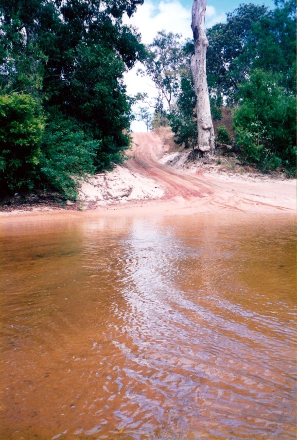
The track was variable. It wound about a lot. There were a lot of creek crossings, but all quite easy, though it took a bit of effort to work out the route through the Pascoe River.

08-20-1998 03 wenlock lockart track.jpg

The Wenlock River crossing on the Iron Range road

08-20-1998 04 pascoe r crossing.jpg

The Pascoe River crossing – bit hard to tell where we are supposed to drive!

We travelled through beautiful rainforest in the Iron Range National Park. The trip in, from the Peninsula Development Road, to the Ranger Station, just north of Lockhart River settlement, took us nearly 4 hours. We booked in at the Ranger Station, to stay at Chili Beach, and paid $7 for a night.

The track from there to Chili Beach was pretty poor. Narrow, winding, rough.

There were a surprising number of people camped at Chili Beach. We had to cruise around a bit to find a spot to camp. We found a site just behind the beach and the coconut palms. It was a bit exposed, and very windy, but I think everywhere there has some wind.

We put up the small tent and John put up an ingenious shadecloth shelter for us, which provided a degree of protection from the wind. We got water from the well there – it was not for human consumption and was very muddy, but would do for washing up. There are pit toilets.

08-21-1998 02 chilli beach camp.jpg

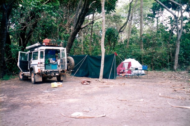
Our Chili Beach camp and windbreak

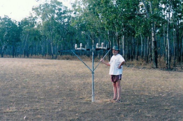
There were lots of rainbow bee eaters around – more than we’ve seen in one place before.

We walked on the wide, sandy beach for a while and found it very attractive. Restoration Island is quite close, and there are other islands dotted around. The tide comes in quickly, here.

A group from the Suzuki Club of SA is camped near us; we chatted to a couple of the members for a while.

Tea was eggs, bacon, fries. I was not all that hungry. Have been feeling rather off colour again, for the past couple of days. My suspect tooth has been aching off and on, since we were at Seisia, and I have been taking Panadol fairly regularly, for that. A bad tooth and these corrugated roads are not a match made in heaven!

08-20-1998-moreton-to-chili-beach

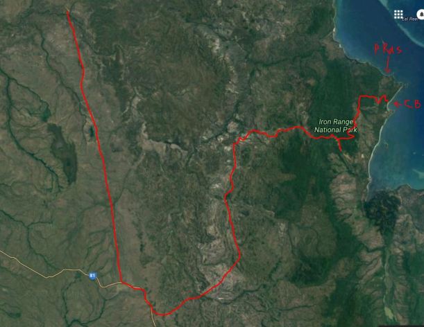
From Moreton Telegraph Station to Chili Beach


Leave a comment

1998 Travels July 28

TUESDAY 28 JULY   WEIPA TO MORETON TELEGRAPH STATION   148kms

John had letters to write and we had share matters to arrange, so it was nearly midday when we left Weipa. Had to go to PO and newsagency first. The girl in the newsagent told us that Stone Crossing was a real problem. Some people who came through yesterday about 1pm got a lot of water in their vehicle. Not for us then – but I bought a tide times book for in case we decide to come back that way.

So we headed out of town the way we came in.

07-28-1998 01 leaving weipa.jpg

Leaving Weipa – slowly!

Some 65kms back along the road, we turned left and took a short cut, through Batavia Downs. It was a rough and corrugated road. Going along that, we began to smell beer. Got out to investigate and saw beer running from under the wheel arch, so we obviously have a beer can problem, due to the rough roads! Will sort it out when we stop for the night – no way are we unpacking the back of Truck by the side of the road.

We did eat lunch by the road side – packed sandwiches.

Turned left when we reached the Peninsula Development Road, at Batavia Downs. A couple of kms further on, passed the Frenchmans Track, to the right, which is one way to get to the east coast and Portland Roads. The main road was better than we’d come across on, but still with lots of corrugations.

John gave me a driving spell after lunch. We were not looking forward to the Wenlock River crossing, which has a bad reputation for causing problems for travellers – strong current, sandy bottom, deep water to one side. Travellers sometimes have to use a raft made from 44 gallon drums to float their vehicle across! My plan was to stop before the Wenlock so we could check it out, and John could drive it. Well, I came to a little shallow sort of creek and drove straight through, with no problems. It wasn’t until we came to the entrance to the Moreton Telegraph Station, a hundred metres or so further on, that I realized I’d driven across the dreaded Wenlock, without knowing it! Too easy. Found out later that it now has a firm, gravel base, courtesy of Telstra crews, who got sick of getting stuck there and arranged for big drops of concrete and gravel into it.

07-28-1998 03 wenlock.jpg

The not so fearsome Wenlock River crossing

It was nearly 3.30pm by this time, so we decided to stop the night at the old Moreton Telegraph Station campground. It cost us $10 – not powered. There were only 5 or 6 other lots of campers in, but they were occupying the shady spots in the really grassy area – there is not a lot of shade there – so we set up away from them.

The buildings here are a bit ramshackle. There are several buildings, including some donga type accommodation units. From our guide book it would appear that it is only 2 or 3 years since a group of tour operators took this place on, to try to start an accommodation business, so I guess they had a lot of restoration to do.

In the 1880’s a route was surveyed for an Overland Telegraph Line, that would go from Laura to Thursday Island, and thus, via Morse Code telegraphy, link Brisbane with parts north and through Asia to the rest of the world. The line surveyed basically followed a straight line. Telegraph relay stations were established near water sources – both for the people manning the stations, and because transport horses needed water. Moreton Telegraph Station was built in 1887. It was built of iron, and like the other stations designed for protection from hostile natives, with shutters that were bolted from the inside, and little gun turrets.

In 1987 Moreton ceased to have any communication and administrative functions.

As we did the minimal set up in the small tent, found that the leaking beer came from only one can – so that was a relief! I wrapped the rest of the slab of cans, individually, in newspaper, to see if the cans travel any better.

Went for a walk back to the Wenlock crossing to have a good look at it, and walked around the station grounds. We found what we assumed was a remnant of the telegraph line – but it was quite strangely on a very short pole.

07-28-1998-02-moreton-telegraph-station

Did John grow or did the pole shrink? At Moreton Telegraph Station.

We had welcome warm showers.

Tea was spag bol.

I couldn’t find any mantles for the Coleman lamp! The one that was on it disintegrated on the corrugations since it was last used at Silver Plains.

Some travellers arrived about 9.15pm and set up camp. I would not like to be driving these roads in the dark!

07-28-1998-weipa-to-moreton

Weipa to Moreton. In this 2016 image, the bauxite mining areas are much more extensive than they were in 1998, and the visible airstrip at Moreton has been much upgraded.