This Adventurous Age

Adventures travelling and working around Australia.


Leave a comment

2007 Travels August 24

FRIDAY 24 AUGUST   FITZROY CROSSING TO BROOME   400kms

Managed a reasonably early start, having been able to stay hitched up.

Refuelled – $1.44cpl.

Fitzroy River from bridge at Fitzroy Crossing. Caravan Park on right

Checked out the free camp area at Ellendale as we passed, but of course M was long gone – although we did wonder if her plans had worked out as intended, and she had even been there. Won’t know till we get to Broome…..

Today’s drive was less interesting than that of yesterday – no dramatic scenery of distant and near ranges.

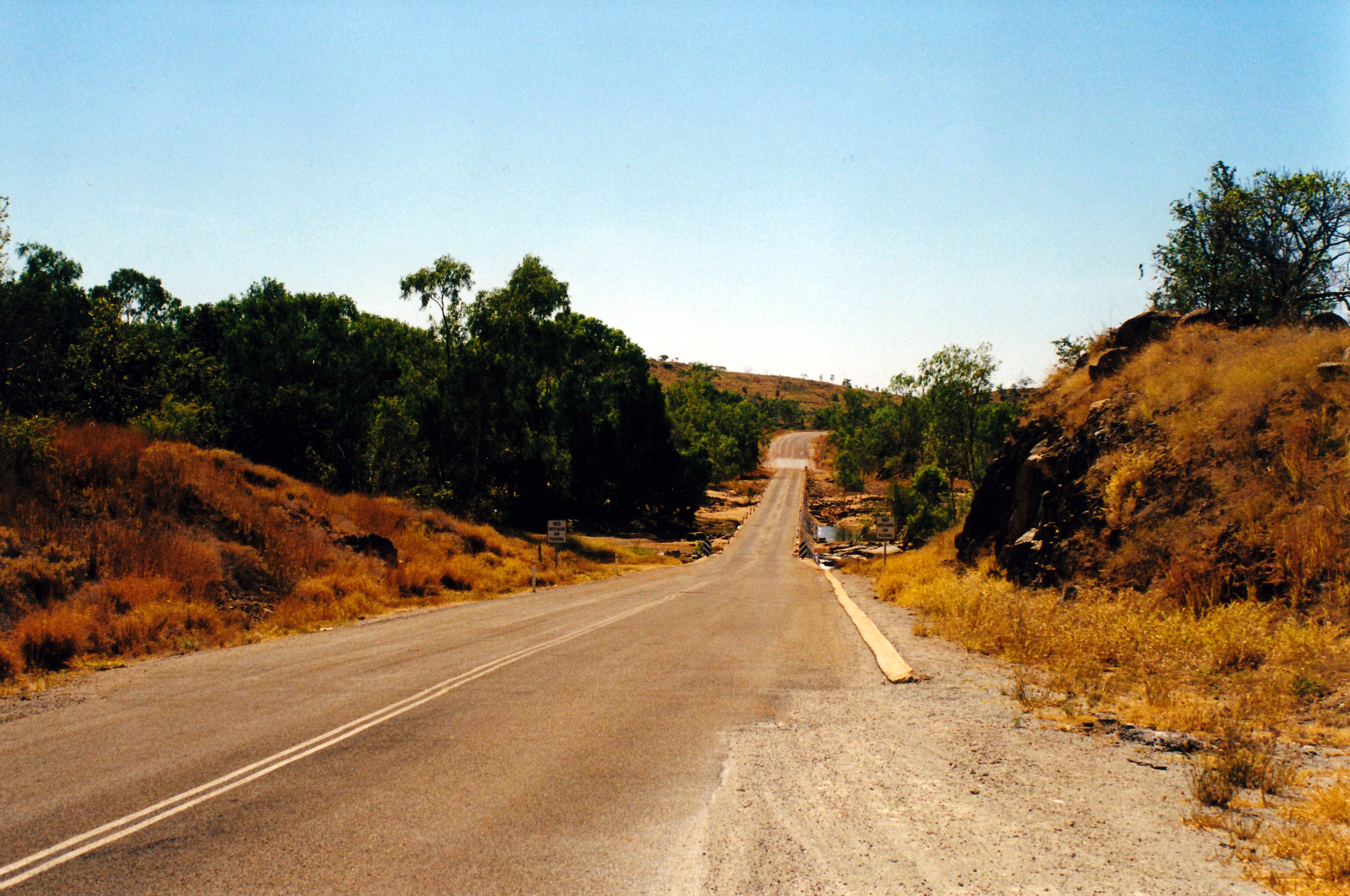
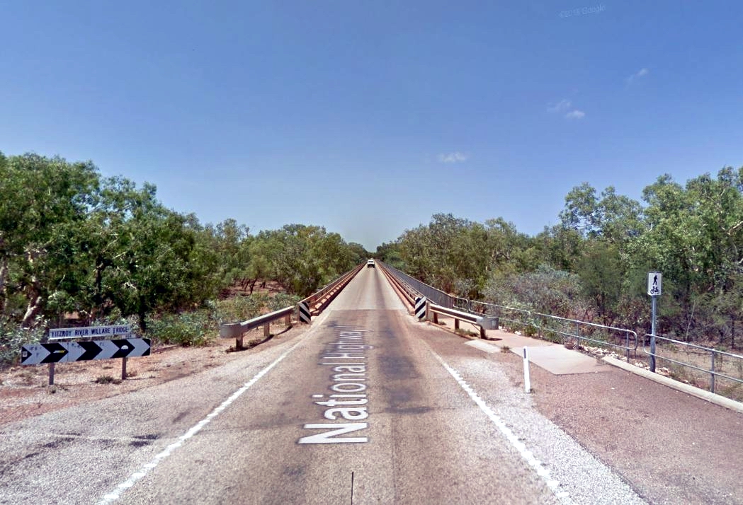
The only points to note, amid the dry and dusty grass and scrubland, were the crossings of the impressive Fitzroy River – at Fitzroy Crossing and again at Willare Bridge, closer to Broome.

Fitzroy River from Willare Bridge

At this time of year, the river was a small flow in the huge river bed. It was hard to believe how high and raging it could become in flood times. In 1993, I’d bought a postcard of the caravan park where we’d stayed last night – with only the elevated amenity block showing amid the floodwaters from the river.

The Willare Bridge was one of the long, single lane bridges that feature in this part of WA. Again, it was hard to credit that, at times, Highway 1 could be closed here by the river in flood.

Willare Bridge (Google)

We reached the Palm Grove Caravan Park, at Cable Beach, Broome, about midday.

M was already there, of course. From her overnight stop at Ellendale, she’d had a good head start on us. She had found Old Halls Creek and its surrounding area, interesting, and worth the visit. But she had driven out to explore some of the area and at Caroline Pool had felt quite intimidated by a group of locals who told her white fellas weren’t welcome there. She didn’t stay round to argue the point.

The caravan park sites were on the small side, gravelled, but adequate. The amenities were reasonably modern, and clean. It was not the most upmarket park we’d stayed in, by any means, and really didn’t justify the $255 we paid for the mandated week’s stay. But, hey, that’s Broome.

M’s site was across the access road from ours, so at least that was convenient.

We heard that two of the Cable Beach caravan parks, including this one, had been sold, to be turned into resort units. That would put the squeeze on caravanners to Broome, even more. It was really hard to find a vacancy in a caravan park here, in the winter months. The overflow area used at this time of the year, at a gun club, was even hard to get into. It is one of those areas that poses real dilemmas for accommodation providers: in the winter months, a few more caravan parks could be easily filled, but for the rest of the year there would be insufficient patronage to be viable.

We set up, then went to the Information Centre in town, to see what we could suss out.

When I say, in town, it is because Cable Beach and the main Broome town were separated by a few kms  of scrub and industrial land. The original town of Broome, and the modern one that has grown up around it, is located on a peninsula that juts into Roebuck Bay. The much more recent development of Cable Beach is located on the other side of this peninsula, facing out into the Indian Ocean.

Broome and Cable Beach (Google)

We drove around the town, looking at the changes since we were last here in 2000. There had been a lot of development and building since then. Broome seemed to be really booming – we thought this might be due to the offshore oil and gas developments. Even Cable Beach seemed to be growing rapidly – and not only tourist resort development, but housing as well.

For our Friday fish and chip dinner, we walked from the caravan park, a few hundred metres, to a van parked overlooking Cable Beach, which did a roaring trade in take away food. The prices were reasonable, the food excellent. It was very pleasant, sitting looking out over the ocean, eating our dinner. Great to be by the sea again!


1 Comment

2000 Travels August 16

WEDNESDAY 16 AUGUST   KUNUNURRA TO OLD HALLS CREEK   399kms

We were up early and away from the park about 8.30.

Drove the rig to a refrigeration business in town, where John had arranged to have the van’s air-con checked. He wasn’t sure if it might need regassing, but they said it was ok. That cost $33.

We left Kununurra about 9.30am, heading west and south.

It was a pleasant drive on Highway 1, with varied changes of scenery to keep it interesting. It is spectacular and dramatic country – “true” Kimberley.

The road varied. It was good (and repaired) in parts. Other parts were narrower, a bit rough, and at times there were no white lines. There were quite a few single lane bridges, some with only very low cement kerb edges. Quite long, too, some of them. There did not seem to be much of a side margin for error, but I guessed they must be better than they looked, because road trains manage them.

08-16-2000 01 ord river causway.jpg

Low level, single width bridge

We shared the driving.

Passed the turnoff into the Bungles National Park. We had been in there on our ’93 trip, so missing that, this time, was not too disappointing. Another for next year?

We had not before travelled the highway, south of the Bungles turnoff, so that was new road for us, between that and Fitzroy Crossing, well to the west.

We noted the track where we would have come out onto the highway, had we driven the Tableland Track. John reckoned what he could see of the country to the west of there  looked interesting. Maybe next year, or the one after?

We stopped to have a look at the upper Ord River, where it was crossed by the highway. There was much evidence of the floods earlier in the year.

08-16-2000 02 the upper Ord River.jpg

The Ord River – upper reaches

The highway went over on a low level causeway – obviously sometimes impassable in the wet season. The road surface had white river level markers painted on it to show how deep the water beyond would be.

08-16-2000 03 ord river depth marks.jpg

Depth markers painted on the road at the Ord River

Right now, it was a benign little trickle under the causeway – a total contrast with the huge, powerful river downstream of the Argyle Dam.

Reached the township of Halls Creek. We drove around to try to get a newspaper. It was not a pleasant looking town – there were many barricades on windows and doors, much graffiti about, groups of indigenes just sitting about.

We didn’t linger in Halls Creek, and were not tempted at all to stay in the town.

Took the Duncan Road to the south, heading for Old Halls Creek, some 16kms away.

John was not happy to find that the road was unsealed – dirt on his nice clean Truck!

It was a pretty drive out there. The road was not too rough.

08-16-2000 07 hillside Old Halls Ck.jpg

The country around Old Halls Creek

Halls Creek settlement originally began out here, with the gold rush of the 1880’s. A prospector named Hall found gold near the Black Elvire River. The settlement that sprung up was by a tributary – Halls Creek. The rush was soon over, but for a few months, there were upwards of 15,000 people there.

The settlement battled on, servicing local pastoral runs, and what passing traffic there was. Water shortage was a problem in the dry season. It was abandoned, progressively, from 1948 to 1954, as the settlement was relocated to the present Halls Creek site, where the airstrip had been built in 1948, and the (gravel) highway rerouted to avoid the hills around the old site.

We booked into the caravan park at the Old Halls Creek Lodge, for $14 for a powered site.

The Lodge was a sizeable establishment, rather run down. It certainly needed some work. The managers had only been in place for two weeks. It was apparently built by a miner, possibly as a means of avoiding some tax, and he had put a lot into it. It could be really nice.

We found the camp ground really pleasant.

08-16-2000 04 camp old halls ck

Our site at Old Halls Creek Lodge

The original settlement remains consisted of a few ruins, street signs out in the long grass, plaques showing what was there. The buildings seemed to have been made from ant bed – or mud from termite mounds, so they hadn’t lasted all that well.

08-16-2000 05 ruins old halls ck.jpg

What remains of the original settlemnt of Halls Creek

08-16-2000 06 ruins close.jpg

These were the most substantial of the ruins

Halls Creek runs through the little valley. It is an attractive place.

We sat outside the van, which was parked up on a terraced level. We had good views of interesting hills around and we watched the antics of corellas having baths under a sprinkler – and ending up looking quite muddy.

I went for a walk around the ruins. John had a sleep.

A fellow camper (a prospector) lit a BBQ fire and invited us to share it, so I cooked potatoes and sweet corn cobs in foil on it. Very nice too.

There was no TV, of course, and the generator that powered the sites went off at 9pm. John played games on his laptop for a while. I had an early night.

It was lovely and quiet once the generator was off – no urban sounds out here.

08-16-2000 to ohc.JPG