
WEDNESDAY 29 JULY MORETON TO DULHUNTY RIVER 77kms
We got up at 8am to an unexpectedly misty morning.
Spent some time wandering about, bird spotting, and found a blue cheeked rosella and a lemon breasted flycatcher.
John phoned Telstra, from the phone box at the Moreton gateway, to extend our Radphone Direct Dial service for another 4 months – paid the $230 cost on credit card over the phone.
We left Moreton at 11am.
As we were leaving, saw the mail plane come in – Cape York Air. John likes the idea of a mail plane flight over all or part of Cape York, so I will investigate that as a possible birthday present for him, in September.
It was only about 40kms to the start of the OTL Track – the little maintained track that follows the route of the old telegraph line and once was its maintenance track. North of Bramwell Station, the main route does a big loop to the east and north, before turning west again and intersecting the old track. This takes it over easier terrain, avoiding the many creek and river crossings that are one of the challenges of the old track, with its straight line route.
The stretch between Moreton and the track junction was very corrugated and had patches of bulldust. From the many crests, the straight line nature of the original telegraph route was obvious.

The Peninsula Development Road – corrugations, and a bulldust patch coming up. The roller coaster nature of the straight road is evident.
We found we could usually tell where there was a bad bulldust patch – because there would be a “wiggle” in the width of the road, caused by drivers trying to go round it – as in the photo above.
At the junction of the OTL Track and the Southern Bypass Road, we committed ourselves to the OTL Track. Even at the junction, it was obvious that the nature of the two routes is different.
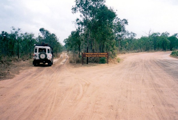
Committing to the OTL Track. The different nature of the two routes north is pretty obvious.
About 4kms along, the first creek crossing we came to was Palm Creek. This was enough to give us second thoughts about continuing on this route: a steep, eroded drop in and rise out, but not much water at the bottom, though.

First view of Palm Creek. Do we really want to go this way?
John decided to empty the 20 litres of diesel from the roof rack before doing this crossing, to reduce top heaviness, given some of the slopes we were facing. Very wise!

What the driver saw dropping down into Palm Creek. Turn left in the water……
Truck and John did the crossing well, with me recording it on film, for posterity – and also because walking it scares me less than being in the vehicle! I was to walk a lot of crossings on this track!
The path down went into the gully from the side, over a bit of a drop, then he had to turn left through the water to reach the way out on the other side.
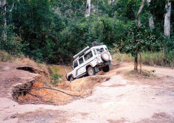
What the passenger saw from her vantage point!

Quite a lean on truck there
John wanted a photo from the water level, looking up the far bank to the Truck on top. He backed Truck into position and got out. Truck started to roll backwards – whoops, forgot the handbrake! It gave us both a hell of a fright. John clambered in and stopped it before it hit the really steep downhill drop. A close shave!

Up and out of Palm Creek – almost a disaster site
The OTL Track was narrow, winding and rough. There are some corrugations, some sand patches, some rock outcrops. It winds, because where trees have fallen, or the track deteriorated, some traveller has just pushed a path around the problem. It is essentially just two wheel tracks, so passing a vehicle going the other way can be tricky.

The narrow Telegraph Track, and an old pole
In places, there were old telegraph poles, but missing the ceramic insulators and fittings – souvenired?
Ducie Creek was wide and looked easy – no steep sides. I walked it before we committed and found quite a deep hole in the centre. Another vehicle had come up behind us and John felt pressured to go, so he did not take proper note of what I was calling to him, which was “turn right at Wendy” as I stood there in the middle. He ploughed straight on past me and through the deeper section. I guess that is what happened to our Weipa neighbour with the drowned engine – but we have a snorkel, and only a few trickles of water seemed to get into Truck.
It was about at this point that it dawned on us that turning back was probably not an option – recrossing those couple of creeks would be harder than going on!
The remaining crossings today presented few problems – we just needed to take care and look first.
It took us until 2.30pm to get to the Dulhunty River crossing, and we called it quits for the day. We were the first campers there and had the pick of the sites on the southern side of the river. We chose a site perched above the rapids in the river – the noise of the river would be great to go to sleep by.
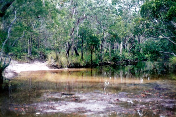
The Dulhunty River Crossing
It was horrible, though, at this lovely camping place, to see long streamers of toilet paper strewn around – there have been some very filthy campers in this place.
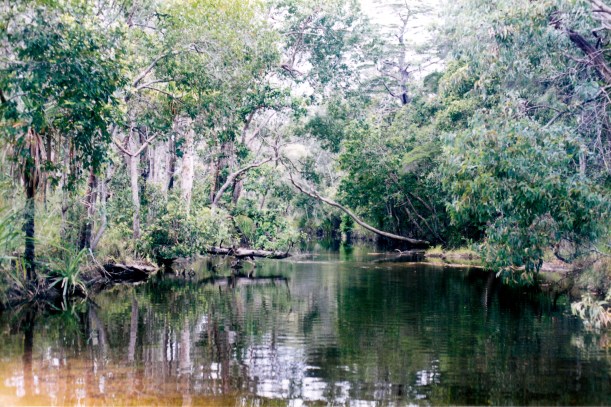
The beautiful Dulhunty River, downstream from the crossing
The Dulhunty looks like it will be an easy crossing in the morning.

Three different exits from the Dulhunty – the effects of vehicle traffic on the track
After we set up the small tent, I did some paddling around in the river and we eventually donned bathers and had a “spa” in a small pool in the rapids. It was most enjoyable sitting in there, with no worries about crocs – and we got clean.
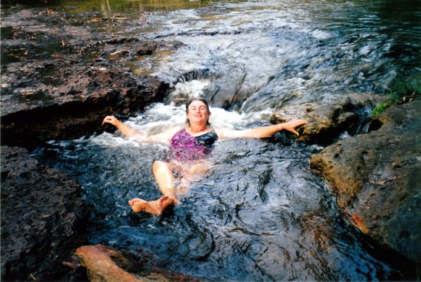
Dulhunty River spa bath
There were some clouds round during today, and even a few spits of rain. It has been quite humid and hot.
By tea time, there were 3 or 4 other sets of campers here and some more over the river. We could hear them using a chainsaw! Why do people have to have big fires when it is so hot and humid?
Tea was soup, steak, fries and some salad.
We did not stay up long, after tea. Travelling such tracks is very tiring. The sound of the river lulled us to sleep beautifully.

The straight line Telegraph Track from Moreton to the Dulhunty River. The Bypass Road can be faintly seen, curving to the east, around the headwaters of the rivers.
