This Adventurous Age

Adventures travelling and working around Australia.


Leave a comment

2000 Travels February 6

SUNDAY 6 FEBRUARY     DOVER

Today was a fairly warm day. Yet another abrupt change from the conditions of yesterday.

We drove south, firstly to Southport. I think I had been expecting this place to be a bit larger, but it really is just a hamlet – but a pleasant little place. It certainly features some excellent sea views.

Southport is the most southerly town in Australia – hard to believe, but it was once Tasmania’s second largest town! It began as a whaling station, gained a big convict station and then supported timber milling. There was a substantial port used to ship timber to England.

When the French explorer D’Entrecasteaux discovered this area, in 1792, he called it Baie de Moules (Bay of Mussels). I think this is much more evocative than the prosaic “Southport”!

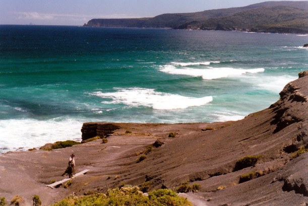
After driving around the few streets of the township, looking about, we drove out Lady Bay Road, to the east, to Burial Point. There were good rock shelves there, but they were no good for fishing from, because of lots of weed in the water – from the bull kelp “forest” there. We saw a couple of snorkellers in the water – maybe looking for crayfish or abalone. We got some mussels from the rocks for possible use later a fish bait.

There was a fenced off burial area, containing a row of flattish mounds – seven or eight of them. Our guide information did not give any clue as to the origins of these graves. We wondered if they were from a ship that anchored in the bay, before there was a settlement? Or from a whaling station? There may once have been wooden markers, of course, but nothing remains there now. A mystery!

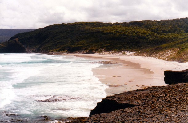
We continued on along the unsealed coast track to Lady Bay, where we were able to park Truck just off the road and have our lunch, looking out over the bay to Bruny Island, where there were, clearly, bushfires. As we ate lunch, watched some wrens flitting busily about.

02-06-2000 01 Bruny Is and bushfire from Southport.jpg

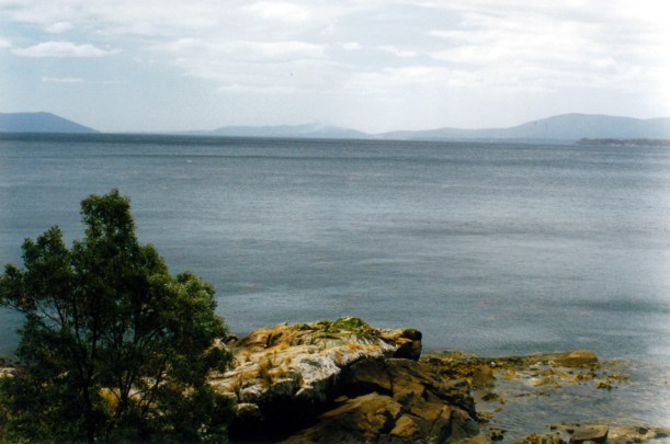
Bruny Island seen from near Southport

Continued following the track. It turned inland and became Peacock Road, an unsealed forestry track that turned out to be a pleasant detour to complete our circuit back to the main highway.

Continued south again, on the Cockle Creek road, all the way to its end. Left Truck there and followed the walk track around the shoreline, to a clearing by the sea where there was a bronze sculpture of a whale – a memorial to the whaling days that were so important around here. The sculpture was done by the same man who did the Steppe Sculptures, and the seal on the rocks at Constitution Dock in Hobart.

02-06-2000 03 Whalers memorial cockle ck.jpg

John and statue of baby whale

Although there is no settlement at Cockle Creek now, in its whaling and timbering days, it boasted some 2000 people! The original whaling station was integral to this.

We loved the bronze whale, and its sheer scale.

From here, John wanted to keep walking around to Fishers Point, and I thought that was a good idea. This was a pleasant walk of about two kms each way, along a series of little beaches, with some rocky and boulder scrambles  in between these; and finally, a short section through scrub.

02-06-2000 john walk on recherche bay beach.jpg

Walking to Fishers Point

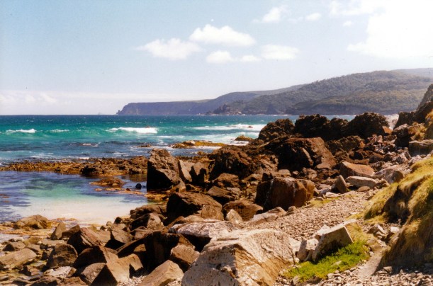
At Fishers Point, which is at the southern entrance to Recherche Bay, there was a navigation light, and the brick remains of an old pilot station that was established in 1836. The fact that this was there shows how much shipping there was around these parts at that time.

02-06-2000 04 Fishers pt pilot stn ruins

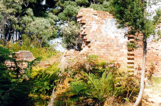
The remains of the pilot station at Fishers Point

02-06-2000 07 Fishers Point Light.jpg

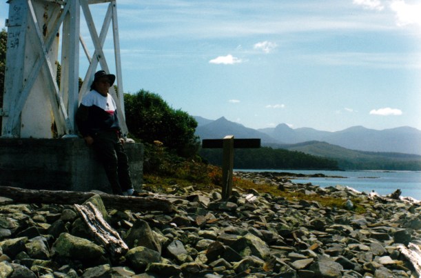
At Fishers Point – navigation light

02-06-2000 08 Recherche bay,mts from fisher pt

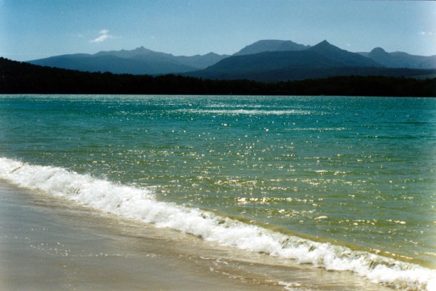
Recherche Bay and the mountains of the south west, seen from Fishers Point

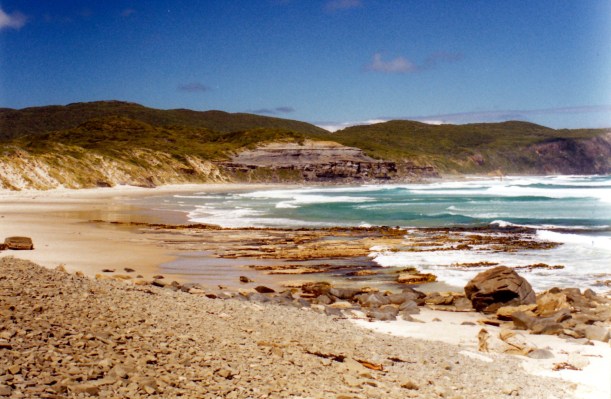
We explored around the Point for a little while and admired the views, then retraced our steps back to Cockle Creek. The walk back was superb, because we were looking across the bay to the dramatic peaks of the southern wilderness. Just beautiful.

02-06-2000 09 Recherche Bay and sw mts.jpg

The outlook as we walked back to Cockle Creek – sun on Recherche Bay

02-06-2000 boat on recherche bay

Almost back to Cockle Creek – buildings and boats

We dawdled by the Cockle Creek for a while, watching little fish swim about in the water under the bridge, and a small penguin (a Little Penguin?) darting around in the water near the creek mouth.

There were lots more campers in the strip alongside the road, than there had been a few days ago. Someone explained that most were probably people taking a four day weekend break, as Monday is the Regatta Day holiday in Hobart and surrounds.

Drove back to Dover. There, we went to the “new” supermarket to buy some snack foods that on impulse, we decided we craved. Also a big tin of baked beans, for tea. I bought some postcards there too – of Adamsons Peak, which is a real landmark, behind Dover.

We drove 118kms today.

We sat outside the van, eating our snacks and having a can of beer. Then M, the park owner came along and gave us two big pieces of fish he’d caught – stripey trumpeter. So we had that for tea, instead of the beans. It was absolutely delicious – a beautiful fish to eat.

After tea, John was snacking on chocolate and broke a tooth on a piece. He took out a big chunk of tooth! It didn’t ache but left behind really sharp edges that were annoying.


Leave a comment

2000 Travels January 31

MONDAY 31 JANUARY     DOVER

Today we set out to tackle one of the adventurous challenges that was on the must-do list. It seemed a reasonably promising day, with some blue sky, quite a bit of cloud, but fine.

We headed south again, down the Huon Highway and to Hastings, the way we went yesterday, then continued further south – as far as the end of the road, in fact, at Cockle Creek.

The road was unsealed for much of the way past Hastings, apart from a few patches of sealed surface where there were concentrations of houses.

It was an attractive and varied drive, mostly through forest, and inland until we came down to the coast at the beautiful Recherche Bay, where the narrow road ran virtually beside the sea.

Recherche Bay was named by French explorers who spent some time here in 1792, for one of the group’s ships. The Catamaran River and Cockle Creek are both fair sized streams that empty into the bay – brown, tannin stained water.

01-31-2000 15  the bay at Cockle Creek.jpg

The bay at Cockle Creek

Along Recherche Bay there are a few pockets of settlement of sorts – Recherche, Catamaran and Cockle Creek. There were the occasional proper cottage or house, but mostly a number of shacks. I presumed that these were on privately owned land that dated from the times of whaling, coal mining and timber cutting in the 1800’s.

There were also bush camping areas strung along beside the road, wherever it was by the sea. These did not have the look of formal campgrounds, but more like places that successive campers had created in the scrub. Clearly, some people had set up more or less permanent camps in old buses and vans – rather unattractive, and feral seeming, mostly. There were some pit toilets in those areas, and some water available.

I suspect this area would be rather crowded with campers in the main summer holiday period.

At one stage, we’d thought about bring the van and camping down here – but I am glad we didn’t. As our main intent in coming down here today was to do the walk to South Cape Bay, we did not spend any time exploring around the Cockle Creek area.

01-31-2000 01  Cockle Creek at low tide.jpg

Cockle Creek – low tide

As it was, we did not begin the walk until midday; it would have been better to have begun earlier, but we are not great at early starts.

There was a bridge – one lane – over Cockle Creek, where it runs into the bay, and just past this was a parking area, information board and the start of the track. This is the South West walking track, a long distance one that comes from Port Davey/Melaleuca, along the coast. It is a similar length to the Overland Track – some 85kms – and takes about a week to walk. But the track conditions are tougher than those of the popular Overland Track, and as there is no road access to Port Davey, hikers generally fly one way. We were just going to do the 7-8km section to South Cape Bay, and back.

We did see several walkers, with packs, seeming to be waiting around for transport. Presumably, these had just finished the South Coast Track from Port Davey. They had that look about them that I recognized – just hanging out for a long hot shower and a really good meal!

01-31-2000 02  Great SW Walk J at start.jpg

Starting the walk on track to South Cape Bay

The walk to South Cape Bay was lovely.  It was drizzly when we left Cockle Creek, but then cleared up and we had sun for much of the time.

The first part was through forested country, skirting hills. The track was a bit uneven and rocky, which was not good for John. We spotted a strong billed honeyeater – new bird!

The next part of the walk was over swampy heathlands, much of it on board walks, on which little lizards were warming themselves. It was the sort of area that required a careful watch for sunbaking tiger snakes, too!

01-31-2000 04 great sth walk tk.jpg

Boardwalk track through swampy country

The last section was through forested creek and gully country. It was a bit hilly and we had to step carefully due to rocks and lots of exposed tree roots.

The track came out at South Cape Bay at the top of an exposed coal rock outcrop. We walked across that to eventually get down to a beach that was about 800 metres long.

From the top of the coal outcrop, there were great views of the rugged coast. Off to the west, we could see South Cape, with Maatsuyker Island in the distance.

01-31-2000 05 sth cape bay matsyker is

Track over the coal outcrop. Distant South Cape and Maatsuyker Island

To the east, was South East Cape.

01-31-2000 08  se cape.jpg

South East Cape

We went down the steps by the black, coal-material bluff, and onto the beach of South Cape Bay. Walked along this to Lion Rock at its western end, on a lovely, empty beach.

01-31-2000 south cape bay beach

South Cape Bay Beach

A couple of hikers eventually appeared – one went up to the campsite that was behind the beach.

01-31-2000 07 Lion Rock South Cape Bay

Lion Rock

At the end of the beach, behind Lion Rock was a sort of rocky, shingle area. It was not possible to go any further along the coast from this point. The South Coast walking track swings inland here.

01-31-2000 09 coast beyond Lion Rock.jpg

The coast beyond Lion Rock, looking to South Cape

01-31-2000 10 coal outcrop and tk

Looking back along the beach to the coal outcrop and where the track back is.

We left there at 3.30pm, to walk back and got back to Truck at 5.45pm. Overall it was a 15km or so walk. Our legs were well and truly tired.

01-31-2000 14  tk back.jpg

Heading back – track, with boards, in heathland scrub

I phoned K from the phone box at Cockle Creek – Australia’s most southerly phone box – and left a message telling him that!

The drive back to Dover – almost 50kms – did not seem too long. We were grateful for daylight saving, though.

Had a lovely hot shower – very welcome on tired muscles.

Tea was beetroot soup, rissoles, potato rounds, onions, egg.

It was a wonderful day.