It was a hot, sunny day, with just some scattered light cloud.
After breakfast, we walked up to Reception, at the main complex. Maybe the campground was a bit further away than 500 metres?
We looked at displayed information and collected walk leaflets. Booked ourselves in for tomorrow’s Ridge Top Tour.
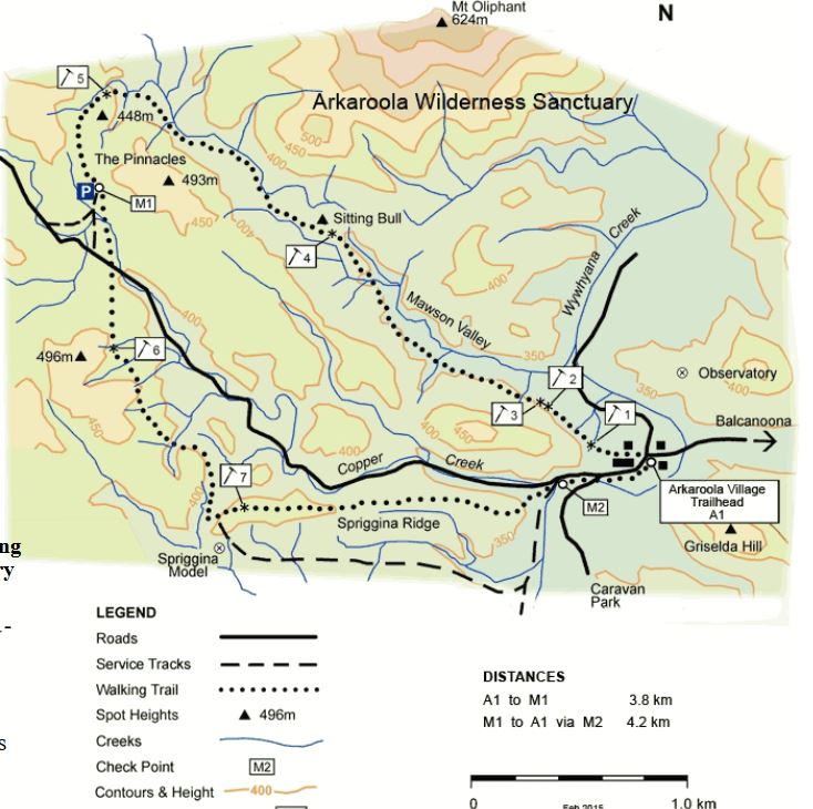
Decided to do the walk that went along the Mawson Valley to the Pinnacles, and return by the Spriggina Track. It was an 8km circuit – a reasonable stroll! After walking back to camp to get organized with things like first aid kit, drinking water, muesli bars, cameras, our proper walking boots, we then had to walk back to the village centre again, to the trail head. So that was a kilometre walked, before we’d even started!
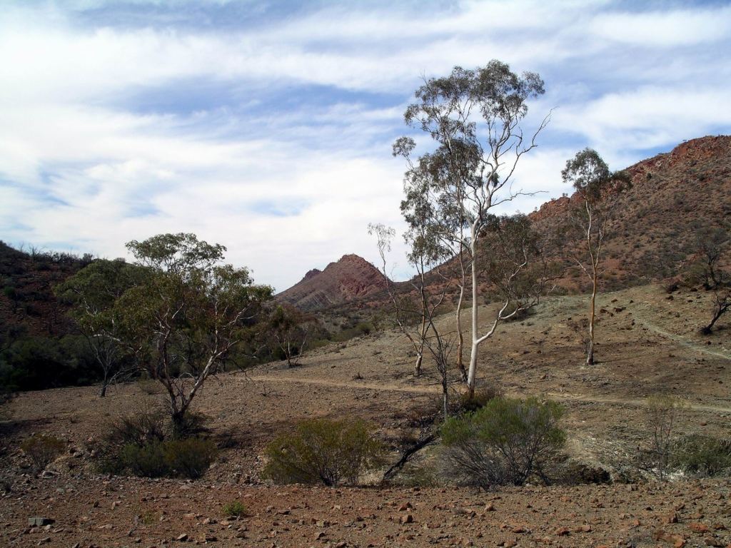
The first part of the trail paralleled a little, dry, creek. It was attractive and photogenic, with a surprising variety of vegetation – almost none of which I could name. Mt Oliphant was off to our right.
Mt Oliphant
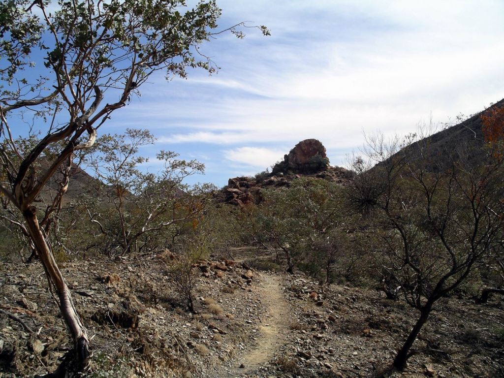
Around half way to The Pinnacles was the granite outcrop of Sitting Bull, named by Douglas Mawson in 1945.
Sitting Bull
The track flanked Sitting Bull and soon we could see The Pinnacles – similarly, granite. These were all intrusions, or plugs, exposed when the softer surrounding land was worn away.
Track flanking Sitting Bull on the way to the PinnaclesPinnacles
From The Pinnacles, we followed a track back to the Bolla Bollana road, crossed that, taking a trail towards the Spriggina fossil replica, then followed low ridges back to the campground. Taking this trail meant that we avoided walking back on the road, but it was more open, hot and less attractive than the first part of the walk had been.
On a flat area below the trail, so walkers could look down on it, Reg Sprigg had built a much enlarged replica of the Spriggina, an ancient fossil that he discovered in 1946, west of Beltana. It was like a worm and was the first animal fossil discovered to have a definite head. It was one of a most significant group of fossils found around the Flinders Ranges area, called the Ediacara Fossils – for the geological age when they crawled around on the sea floor. They were the first multi-celled animals to appear on Earth, some 600 million years ago.
The Spriggina replica (Zoom)
From the last part of the trail, as we came along the ridge, there was a really attractive view of the campground, with Griselda Hill behind it.
The campground and Griselda Hill
John found the latter part of the walk hard. Neither of us was very fit, after the ailments of the past few months. The shingles that John contracted, back in February in the Pilbara, really knocked him about. I was hoping that a recent cortisone injection had finally fixed the troublesome Achilles tendon that plagued me all last year. I was pleased with how it stood up to this walk – a positive sign. M, of course, the former PE teacher, was totally fit and agile!
The route of our walk
We had a late lunch back at camp and relaxed in shade there for the rest of the afternoon.
M drove up to the mechanic’s to collect her repaired tyre. They had found there was a hole in the inner tube, caused because some drongo at the tyre service place, back home, had left a valve cap inside the wheel when her new tyres were put on, last week! Why is it so hard to get competent workers?
There were notices up, that the Gammon Ranges National Park, to the south, would be closed for feral and weed control work, in a week’s time, so we would have to do all that we wanted to, there, before then.
As we pored over maps and brochures, I was already suspecting that a week would not be long enough, here.
Tonight, sitting outside, we faced the other way and watched the moon rise over the hills. The moon always seems larger, here. The stars are certainly brighter.
Today was my son’s 33rd birthday. We’d acknowledged that before we left home.
We packed up and hitched up as efficiently as we could, with a big trip ahead of us today.
It was a long day of driving – on the Barrier Highway to Yunta, then on dirt roads north past Frome Downs Homestead and Balcanoona, and on to Arkaroola. The roads were firm gravel and, for the most part, pretty good to drive on. Some of the sign-posting, or lack thereof, left a bit to be desired.
Topped up the fuel again at Yunta – now, in SA it was $1.29 cpl.
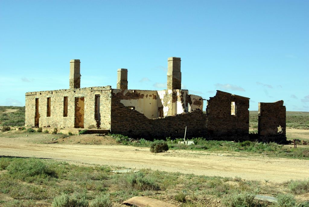
Some 34kms north of Yunta were the Waukaringa ruins. We spent about an hour browsing around these.
Hotel ruins Waukaringa
In the 1880’s, a gold mine was established here and a township grew up rapidly, as tended to happen when there was a promising find. By 1890, it had a population around 500 people. As the gold petered out, the population dwindled. The hotel licence, however, was not surrendered until 1964.
The skeleton of the old hotel was the most obvious ruin, but there were others, plus mining relics, scattered around and up on the low ridge where the actual mines were.
It was evident that the area around the hotel ruins was sometimes used by campers.
Further on, we stopped to eat lunch, near the dry Wilpena Creek ford, just beyond Frome Downs.
Of course, after we started off again, there was a spot that would have been better, with a few trees by another dry creek.
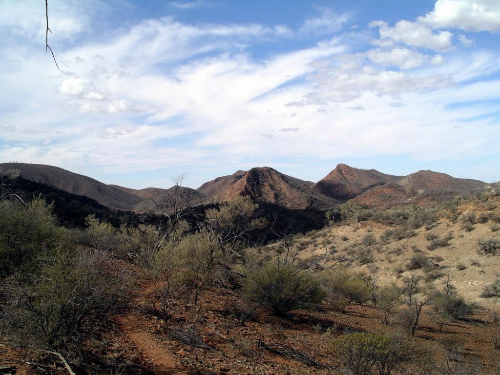
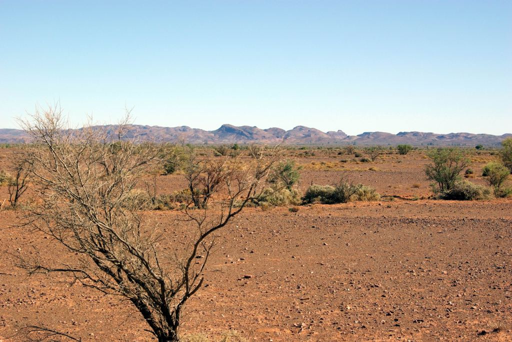
Although we were traversing flat, stony country, in the distance to the west, was the line of the Flinders Ranges.
Flinders Ranges – well to the west of our road.
The road crossed a gas pipeline, from the Moomba gas fields near Innamincka. Here was a bit confusing. A road runs alongside the pipeline and it looked like we should go right, but the correct way was straight ahead. For once, I got it right!
As we progressed north, the flat, barren, stony plains were replaced by more rugged country, with more ranges apparent. This really was an interesting drive. We crossed a number of dry creek beds, many with low trees and scrub growing along them, and then red gums. Essentially, we were skirting the western edge of the dry salt Lake Frome, but at a distance sufficient that we could not see it.
Balcanoona, once a sheep station, is now the base for the Rangers of the Gammon Ranges National Park, which takes in country mostly to its north and west. Arkaroola, where we were heading, is about 30kms north of Balcanoona, and just on the eastern edge of the National Park.
I had hoped to stop at the Ranger Base, to see if I could get any information about the National Park that I didn’t already have, but John wanted to push on. He could see the end to the day’s driving almost in sight!
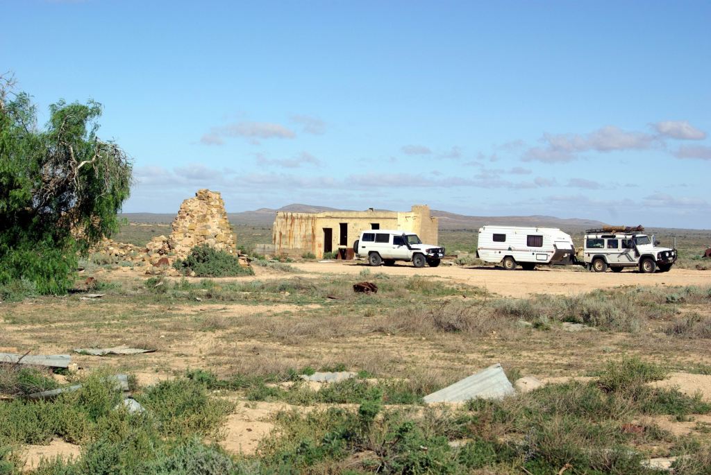
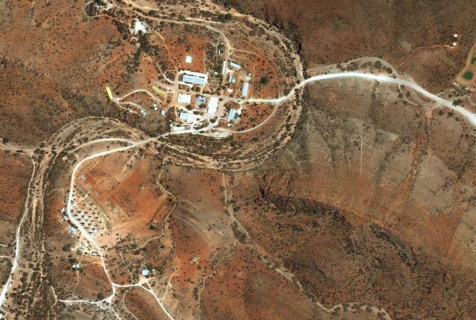
We got into Arkaroola mid-afternoon, so we had made good time. We parked near the Reception area of the outback resort that is Arkaroola and booked ourselves into their campground. As well as this, they had motel style units and some cabins – so a range of accommodation. The campground was about 500 metres distant from the Village hub.
Our powered site cost $20 a night and, because we booked in for a week, the 7th night was free. M was only charged $15 a night, because she was travelling solo – so many places will not make that concession, even though it seems fair. John and I had visited Arkaroola a few times previously – it was a place we loved – but this was a first for M. Hence the longer stay.
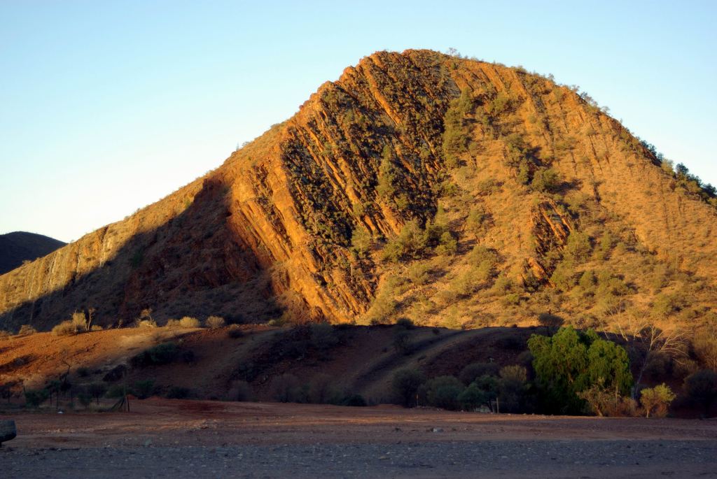
We had a pleasant area, designed to take two outfits, on the top level of the tiered campground, with a great view across the very scenic area to Griselda Hill and the surrounding ranges. The camp ground felt very much as if it was in a pocket, surrounded by stark and rugged hills.
Griselda Hill, from our camp
The campground was gravel surfaced, as one would expect in such an arid area.
Our site had a fire pit and BBQ plate and there was a bore water tap. We did not hook up to the latter, as we preferred the better quality of our own tank water, but filled containers from it for washing up. The nearby amenities were dated and basic, but spacious and clean. Let’s face it – really, all one needs are a clean and functional toilet and shower. Frills are able to be dispensed with.
We set up for our extended stay. The afternoon wind made putting up M’s living tent a bit tricky. We needed the 4 inch masonry nails that John carries, to anchor the tent ropes in the rock hard ground. From memory, it was actually one of our earlier tent based camping trips to Arkaroola, that got him into the habit of carrying the masonry nails – for places like this where tent pegs just did not have a hope!
Whilst M slept in the Troopy, it was not set up inside as a camper. For overnight stops she made do with her camp stove on a small folding table, but when staying longer, set up a tent for cooking and living in. This system had evolved over the previous couple of years of travel, but she was yet to get the right mix of convenience and comfort. A work in progress.
The van had travelled well. With the pressure scoop hatch open, and cardboard taped across the vent in the lower door, very little dust had gotten inside, though we’d done about 300kms on dry and dusty surfaces.
Almost immediately upon arrival at our site, M’s front tyre went flat. After setting up, we changed it and she took it up to the resort complex to the mechanic facility there, for repair.
We sat outside together, to eat tea, and stayed there for a while, after. We hadn’t thought to gather firewood on the latter part of the drive here, but would rectify that sometime soon.
Arkaroola Resort complex at top, campground lower left, showing formal sites, with large unstructured camp area beyond it. (Zoom)
Unseen by us, the full moon rose behind us, but we were busy admiring the myriad of stars spread out above us. The skies here were so clear that Arkaroola has two proper astronomical observatories.
We finally felt like we were getting away from the rat race again!
Arkaroola has an interesting history. It sits in the midst of a really ancient landscape, buckled and tortured over time. Some of the geological structures here are 1.6 billion years old, pre-dating animal life on Earth. Europeans moved into the area in the 1860’s, chasing copper, as happened in other parts of SA too. As was common, the mines did not last long, but their relics are dotted about the area now.
From the early 1900’s, it was a sheep run, in very marginal country.
The ancient rocks of Arkaroola contain unusually formed radioactive deposits and “hot rocks”. Uranium was found and briefly mined from 1910 – with great difficulty given the terrain. The events of WW2 led to a revival of uranium exploration and mining on Arkaroola.
In 1968, the Arkaroola Pastoral Lease was bought by the Sprigg family, with the aim of setting up a Wilderness Sanctuary. The very interesting and talented geologist, Reg Sprigg had visited the area with mineral survey parties and with (Sir) Douglas Mawson of Antarctica fame. He became convinced of the unique nature of the area and the need to act to conserve it. Back then, such private sanctuaries were unusual, but the government of SA was not prepared to buy the property. A huge effort was then made to get rid of the feral animals that infested the place and threatened both its fauna and flora. The development of the tourism aspect of Arkaroola was a means of partly funding the place, but also showing visitors its special qualities. The Sprigg family still runs Arkaroola.
In this region, of course, the Flinders Ranges and Wilpena Pound are the best known tourist destination. The more rugged and arid Arkaroola and Gammon Ranges are much less visited – in part, because of the unsealed access roads, in part perhaps because visitors assume they have “done” the Flinders Ranges and hence there is no need to look further. They don’t know what a superb area they are missing!