
SUNDAY 6 AUGUST MITCHELL PLATEAU
For some time now, our lilo has been steadily going down through the night. John has to pump it up again in the middle of the night – he gets that job – and then it is down again by morning. Does not make for a really great night’s sleep.
We were up about 6.30am, to a hot, sunny day.
We began our walk to the Falls at about 8am, before it got too hot. John was in a hurry to leave, and worried that we seemed to be the last walkers to leave. He’d gone to the pilots’ base about 7am to book our flight.
It all became a great rush to get lunch ready and get going, and in the flurry I could not find my bathers – knew they were in the bottom of my clothes bag, somewhere.
The track was pleasant walking – single file for the most part, and needing care because of rocks and tree roots. In a few places we needed to scramble over rocks.
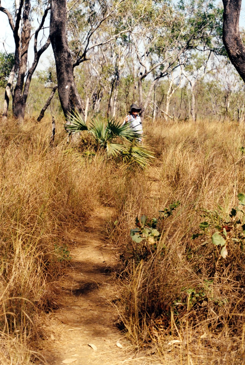
Walking track to the Mitchell Falls
It did not take us long on the track to reach the Little Mertens Falls, where there were very attractive rapids, and small falls, upstream, and a long fall downstream of a plunge pool.

Rapids on Mertens Creek
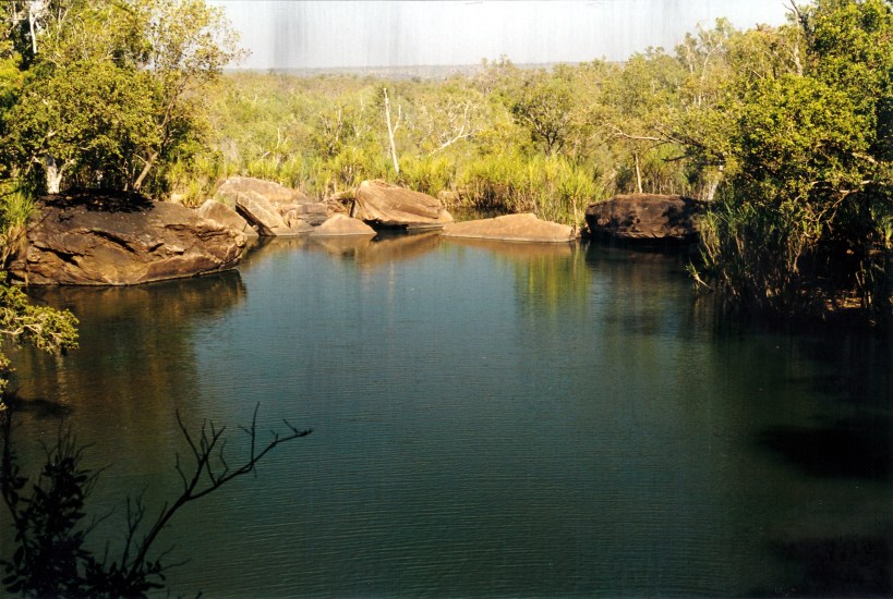
Plunge pool at Little Mertens Falls
We admired the pool and falls for a little while, and then John found the way down the side of the small falls to their base. There was some aboriginal art work on the overhanging ledge beside and under the falls. It was interesting – using mostly colours of brown and black, like we’d seen at Kalumburu. There must be so many art sites throughout the Kimberley. I ondered to what extent they had been documented and analysed by white scholars?


Rock art in cave behind the Little Mertens Falls
It was very cool and pretty behind the falls, with ferns growing in the moisture.

A fernery in the micro climate behind the Falls
We continued on the walking track, past some more art work beside Mertens Creek, to the Big Mertens Falls. These were a huge, single drop down into a narrow, very deep gorge. The sides of this were vertical and there was a long view down the ravine.

Big Mertens Falls
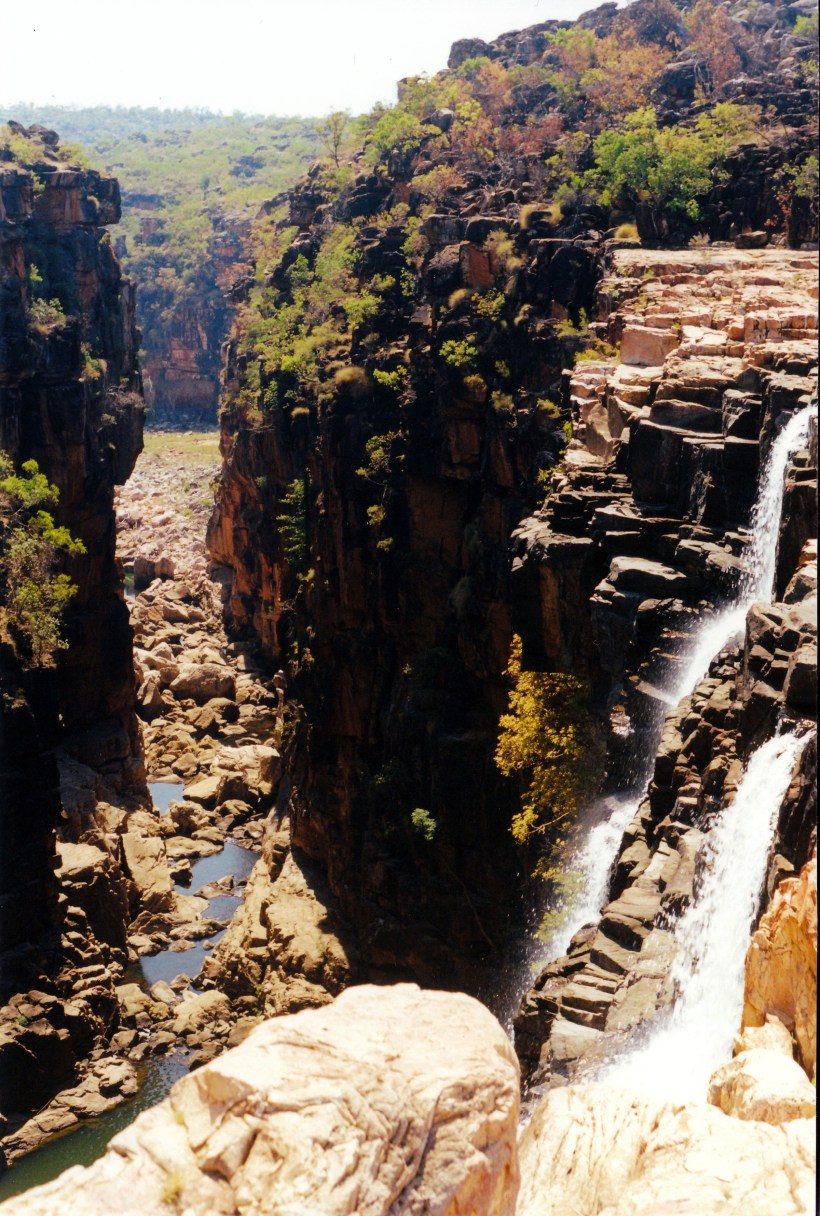
Looking down the gorge of the Big Mertens Falls
We explored around the top of the falls area for a short time, then had to cross the top of the falls to continue on the walking track. The way across felt uncomfortably close to the edge of the ravine.
The track crossed the top of the Big Mertens Falls
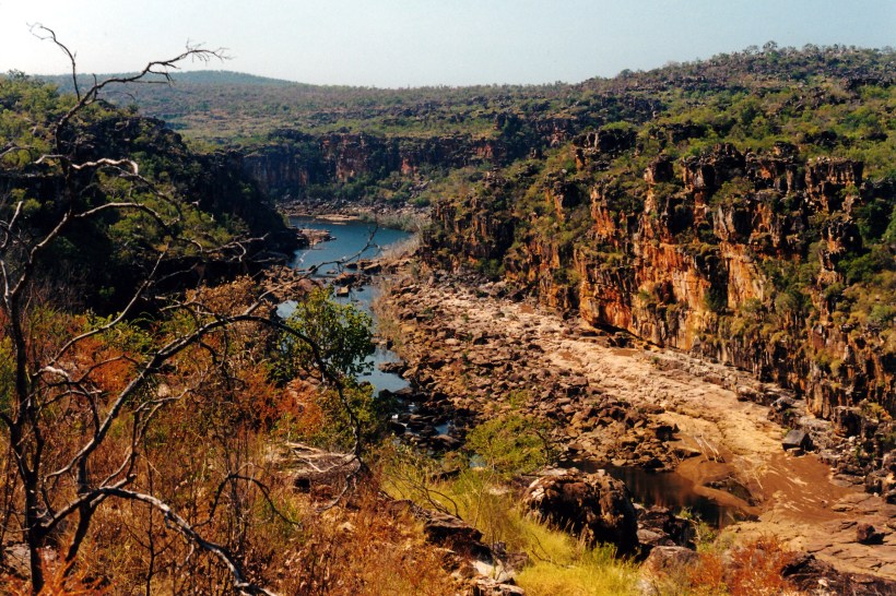
From there we skirted round a low hill, then it was a bit of a scramble over a slabbed rocky area and down to the Mitchell River, above the Falls.

The Mitchell River, seen from the approach track to the Falls area
It was all absolutely spectacular.

Looking down the Mitchell River Gorge
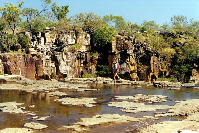
We had a look around the top of the falls, before taking off our boots to cross over, through some small rapids.

Crossing above the Mitchell Falls
We had a swim in the pool back a little from the top of the falls. John had his bathers; I swum in my clothes – it was too tempting to pass up. It was beautiful and cool and it was lovely to feel clean again. It took me a while to drip dry though!
We ate lunch sitting on the rocks by the pool.
A guide brought two women near us, and we talked. He had tentatively arranged for them to go back on the same helicopter flight as us, but they now said they’d walk back. Him doing that meant that there was no other chance for the remaining two seats on our flight to be sold, so we ended up having to pay the full $100 each. I felt this was a bit unfair to us.
After lunch we went walking and scrambling around the top of the falls and downstream a little, to see what perspective of the falls we could get from there. Did some rock hopping. Managed to get down a little gully that gave us good falls views.
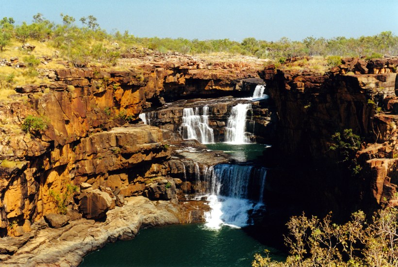
Mitchell Falls – the top three tiers seen from the side of the gorge
We got some excellent views back upstream, of three, then four, drops of the five drop falls.
These have to be the BEST falls we have seen in Australia.
There was a lot of water coming over, too – they would be immense in a big wet season. Of course, the only way to see them then would be from the air.
We filled in time around there, taking photos and just admiring the whole place, until it was time to make our way back to the little plateau by the top of the falls, that the helicopters used, for our 2pm flight.
The pilot actually came about 2.20pm. He was a very taciturn young man, with an attitude that we were just a chore to be managed, rather than welcome customers. John went into the back seat behind the pilot, and I was put in the front seat. There was no front door on the helicopter – to enable a better view.
The pilot did not give any assistance with getting set up for the flight. I was left to work out how to do up my harness myself. He did not help, or check it, just shoved some headphones across at me. He was focussed on some girls who were sunbaking topless further across on the rocks. Because I was trying to put those on, and do up the harness, I finished up with the mouthpiece digging uncomfortably into my neck. I still was not sure about the harness when we suddenly took off and dropped straight out into space above the falls. I was petrified that I’d fall out, so hung onto the door frame – very tightly!
The valley of the Mitchell River
I did not feel secure or at ease during the entire flight, much of which was on a sideways slant, to give us views, but which put me on the “downhill” side.
I managed a few – one-handed – photos – but it was a pity I could not do it properly.
We flew over the falls for a bit, then went up high enough to get a good perspective right back over the river, the falls, the plateau, and where the gorge of Big Mertens Creek meets the Mitchell River, downstream from the falls.

Mitchell Falls seen from the helicopter
Then we flew downstream, over the lowest falls, to where the tidal influence meets the fresh water.
The plateau nature of the area was more evident from the air, as was mile after mile of dissected sandstone block country. It looked so vast, with just the slash of the river course through it.
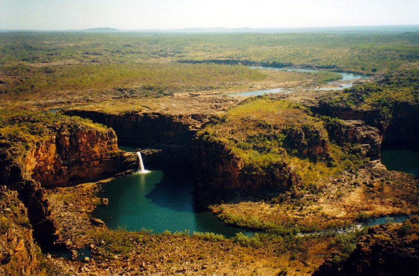
Mitchell Falls, Plateau and River. A helicopter is on flat area in photo centre
There would be so many scenic places that we do not get to see, because they are only accessible from the air, if at all.
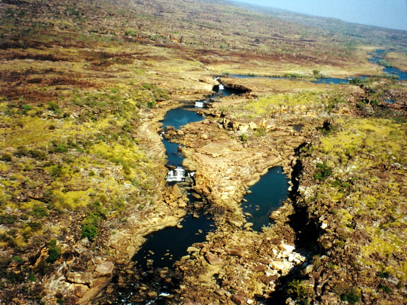
A vast area of wilderness
The pilot gave almost no commentary. He did much fiddling with his radio and there was a lot of static noise from that. He talked at length on the radio with someone about bring back a forgotten towel. So we did not feel that we got any value in the way of informed commentary. We had been expecting something like a mini aerial tour, but what we got was just an aerial taxi service!
Coming in over the campground to land was interesting. The camp area was much larger than was evident on the ground. We could see Truck and our tent.

The campground at the Mitchell Plateau. Our red and green tent is in photo centre
Even though we had to pay the full amount, seeing the area from the air was worth it. That was a great anniversary present.
I felt quite exhilarated after the flight. Maybe it was just relief at surviving! My first helicopter flight. Pity about the attitude of the pilot, though.
We relaxed at camp for the remainder of the afternoon, reliving the experiences of the day.
Tea was potato rosti, egg and bacon.
The moon was beginning to be evident again at night, after some dark ones.
