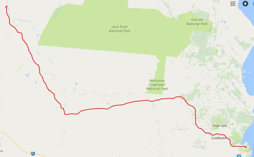
SUNDAY 5 JULY COOKTOWN TO KALPOWAR CROSSING 184kms
It took us two hours to pack up the camp, this morning!
It was hard on John’s leg – he did too much of the heavy lifting and bending. He wanted to protect my back, but he is also not good at standing by while someone else does the work. He expressed some doubts about continuing on, but we decided not to change our minds at this stage. Surprisingly, his leg eased somewhat with the driving, despite a heap of gear work. He let me do more of the heavy stuff when we set up camp again in the afternoon, though.
On the way out of Cooktown, we got diesel – 79cpl. It is a while since we have paid that much, but I suspect it will only get worse, further up the Cape.
We took the road out of Cooktown that goes along the Endeavour River, crossing it on a bridge, then passing the airstrip. There was a mix of scrub and farmed country. We passed the Endeavour Falls Caravan Park, some 30kms from town. We’d moved onto dirt road, and then came to our first creek ford for this expedition – but not the last. It was by Isabella Falls – a low cascade – and we parked and went to look at these.
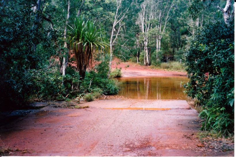
The first water crossing of the Cape trip – on the Battlecamp Road
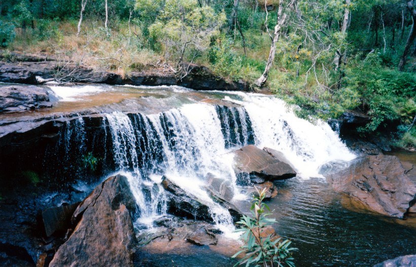
Isabella Falls
Only a few kms beyond the falls we were into a patch of rainforest, and then climbing up into some range country, where the road was bendy. This lasted until the Normanby River ford, some 65kms from Cooktown.
Overall, the Battlecamp road was not too bad. There were some corrugated areas and some shallow sandy patches. There were some gates to open and close, but there were a couple of vehicles close behind us, so they got to close them!
Most of the way was through the savanna type wooded grasslands – quite tall, dry grass. For a while we ran parallel to the Battlecamp Range, which was a bit like some of the flatter parts of the Grampians, with shallow, cliff-like escarpments that seemed quite rugged. We could just glimpse parts in the distance.
The Battlecamp name comes from the 1870’s, when a group of people heading for the Palmer River goldfields were attacked by a large group of aborigines, somewhere along this route.
The Normanby River ford was shallow and easy. The Laura River was dry at the crossing, with a very wide, sandy (deep sand) bed – flattened by traffic, so it was not too hard if one followed the tracks of others. I would not want to try this crossing if there was much flow in it.
We were “ambushed” at the ford by a papaya fruit fly inspection point. We had heard there had been quarantine imposed up the Cape because of a fruit fly outbreak, but thought inspection would only be on the main road, so had not bothered to get the fruit we’d bought in Cooktown certified. So we declared our apples, pears, bananas and passionfruit. They allowed us to eat the bananas on the spot, then remove the cores of the apples and pears, and take the rest with us, plus the insides of the passionfruit. I forgot until later that we also had grapefruit, but don’t think they would have contained the problem bugs.
Ate our lunch at the checkpoint, chatting with the staff there. They recommended we camp at Kalpowar and told John to try detecting gold in the Mossman River, up from where it joins with the Laura River (but I could not later work out on the map where she meant!).
Just beyond the ford was the historic Old Laura Homestead, which we stopped to inspect. This dates from around 1900, and was built using termite resistant ironwood timber – thus it is still standing! It is a great example of the pioneer style architecture of these parts – using timber and corrugated iron, with shutters and wide verandas. As well as having to try to provide some comfort and cross ventilation for cooling, the early settlers felt they had to have their dwellings fortified against aboriginal attack.
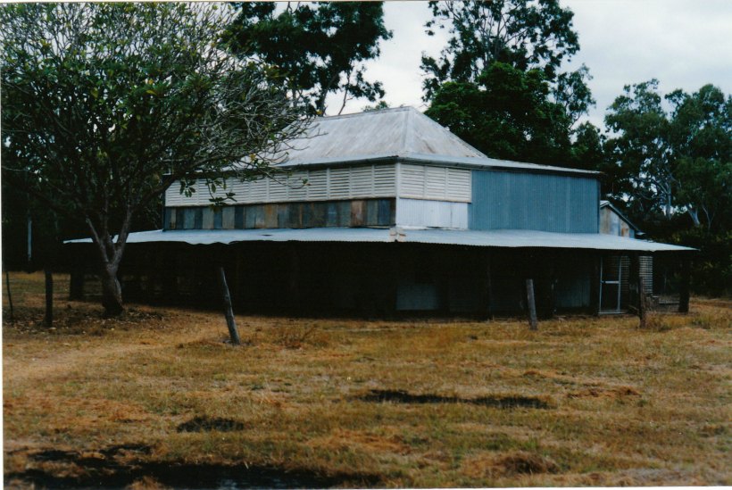
Old Laura Homestead – typical of Cape pioneer style
Just beyond Old Laura, the Battlecamp Road ended at the Lakefield Road, where we turned right. We intended to call in at the main Ranger Station, further on, but that was closed – being Sunday, I guess. So we continued on to the Ranger Station at the old Lakefield Homestead, crossing an increasing number of little dry creek beds.
At Lakefield, we were told that the only vacant site left was Number 10, Kalpowar, so we booked that – but for two nights only. We want to do some exploring of the Lakefield National Park, but thought Number 10 might not be a good site, and we might be able to change later. But it turned out to be lovely – a huge grassed area on which to put the tent, high on a bluff overlooking the Normanby River and the Kalpowar Crossing, where a rough track goes across the river to Kalpowar Homestead and on towards the coast.
We had a big area, even though there were neighbours on both sides. It was much better than the commercial site we’d left this morning, and only $7 a night! Behind where we put the tent there is quite a thicket of scrubby trees, vines and shrubs.
Our site has a fireplace, too, and there is a tap not far away. There is an amenities block with flushing toilets and even a shower – cold – but we were to find this refreshing, after the initial shock.
We set up camp, with the big tent, without rushing it, then relaxed over tea of cold chicken – the last of it. I had to stew the peeled apples and pears.
Found that, at night, we could hear the water rushing over little rapids in the river, quite clearly – wonderful. We are very happy!