
MONDAY 9 MARCH QUEANBEYAN
The day was warmer and still with some wind.
John wanted to do a tour of the Australian Institute of Sport that started at 11.30, so we left the park in good time to drive back into Canberra again and back out north again – not too far from where we were yesterday. I am already finding the little map I bought is invaluable. There was more traffic to negotiate today, being a weekday. We got fuel in Queanbeyan, on the way through – 74 cpl.
The guide for our tour was a wrestler, in the 75kg class. Thought the tour was good value at $8 each. Here too the pool was closed and drained because of the diahorrea spread through pools. There was maintenance work being done on it. I suppose this must be a setback for the swimmers who usually train here – wonder if they have been sent away? The tour went until 1pm, with us walking all over the establishment. It is a very big complex; superb training facilities for such a wide variety of sports.

At the Australian Institute of Sport
After that, since we were on this side of town, decided to go up Black Mountain and visit the Telstra Tower that is such a landmark over Canberra. Admission to this cost $3 each. I battled my dislike of heights in order to see the great views – 360 degrees, all over Canberra. I even made it out onto the outside platform, in order to take photos. Could clearly identify all the major landmarks, clustered along both sides of the central Lake Burley Griffin. Inside again, bought a postcard to send to K, emphasizing the fact that I had been up so high!
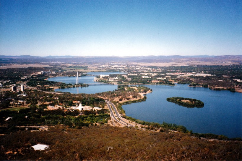
From the Telstra Tower: Civic area to left, Capital area to right, and linking bridge
On the way down Black Mountain, stopped to take a photo of the Telstra Tower, but found that the angle did not really show the true height of the structure.

The Telstra Tower, from the road down Black Mountain
Canberra was purpose built, in the early part of the 20th century, to be the capital of the newly federated Australia. Before selection for this purpose, the area had been a prosperous sheep grazing location. Jealousy and competition between Sydney and Melbourne meant that the new capital had to be distant from both, although the Federal Parliament was based in Melbourne until the new Parliament House was ready to occupy, in 1927.
A world wide design competition was held for the design of the new town, won by the Griffins husband and wife team; the central lake formed by the damming of the Molonglo River, is named for him. The design placed the centre of government – Capital – on one side of the Lake, and the commercial centre – Civic – opposite it on the other side. The photo above shows the road bridge that joins the two. The designers were into geometric shapes – circles around Capital, hexagons around Civic; the triangle that radiates out from Capital Hill and takes in the War memorial area. Very striking on paper – but still a bugger to navigate around!

The western end of Lake Burley Griffin; parts of Canberra are surrounded by pine plantations
Back at the van, had a very late lunch of rolls.
John did much to-ing and fro-ing to the phone box, trying to make contact with his daughter and with friend H. Eventually he got onto each of them and made catching up arrangements for this coming week.
I had BBQ chops for tea and decided to cook these on the electric BBQ provided by the park. It took forever to cook the chops and cost us $4 in coins to run the thing for long enough to do so. We decided that this is not the way of the future! I cooked stir fry vegies at the van to go with the chops.
The night was chilly again.
